When you want to see the stars, find someplace dark
NYPL Digital Collections Online
The New York Public Library has just published 187 thousand digital images online. The collection is staggering in its volume, a collection of images that ranges across the spectrum of American and even world history. One could publish an interesting blog simply mining this huge collection for the historical tidbits it contains. World events to restaurant menus, there is just so much there.
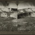
An eruption taking place in the Mokuʻāweoweo caldera of Mauna Loa. Credit: NYPL Image CollectionI did a few quick searches for interesting Hawaiian images. Most of the images showing the islands are either postcards or stereoscopic pairs. There are views of typical tourist scenes such as Diamond Head and surfing at Waikiki. There are quite a few images of the plantation era, sugar mills and such, as well as quite a few simple “pastoral” images with little context or interest.
In addition to the images there is a great deal of other material. Old engravings and illustrations, maps, even menus from restaurants dating back a century. I will have to refer to this collection when looking for illustrations in the future, there is a treasure trove of material here.
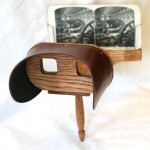
Most of the interesting images I found were stereoscopic pairs. Stereoscopic pairs were incredibly popular in the late 19th and early 20th centuries. While many might be familiar with the View-Master style stereo viewers of the 1950’s and 1970’s, the original version of this used a side-by-side print in place of a transparency.
A reproduction Holmes steroscope. Credit: Davepape via Wikimedia CommonsThe original viewers used a set of lenses to see the stereo effect, similar to a set of glasses, held to the face in a small frame that correctly positioned the viewer and print. The most common design was developed by Oliver Wendell Holmes in 1861, allowing the flourishing of an entire industry creating stereo pairs of common landmarks and events. You could buy stereo images alongside the postcards at any gift shop as you traveled.
There are tens of thousands of these stereoscopic pairs in the NYPL release. This includes dozens from the Hawaiian islands. A couple of the most interesting images I found are a couple views of the eruptions at Mauna Loa or Kilauea. It is interesting to compare these old photos to the modern landscape. The volcanoes have changed markedly, so to have the landscapes modified by man. To look through the images is a lesson in change, either natural or human driven.
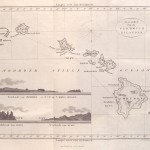
Map of the sandwich Islands (Hawaii) issued in 1835 by Jacobus BoelenSome museums and libraries have a habit of holding their photographic and painting collections very closely, almost jealously. Despite, or perhaps because, the fact that the material is long past any copyright protection. The images are rightly part of the common domain, the visual heritage of all of us. It is quite nice to see mass digitization of the imagery, a concerted effort to make these image collections available to everyone. This is our history, our heritage, available to anyone with an internet connection.