
Learning where you can, and cannot fly is a basic part of learning to pilot a drone. To aid this there are several mobile applications that a pilot can use to check the airspace status of a potential flying site. Just scroll that map and select a site to see the warnings.

I have downloaded and used both for flight planning applications around the island. The island of Hawaiʻi offers some spectacular scenery that has made learning to fly the drone quite enjoyable.
Basically the official FAA B4UFly application sucks. A blunt expression, but appropriate, it truly does.
The first thing you notice in B4UFly is that restricted airspace does not immediately appear on the map as you scroll around. You have to click on a potential area and wait for up to a minute to see any airspace restrictions. This could easily lead a drone operator to believe that an area is not restricted, when in fact it is.
AirMap has no such difficulty, all warnings appear immediately on a selected map view. On B4UFly you need to tap on a site before restrictions appear, some do not appear until you attempt to plan a flight, and some do not appear at all.
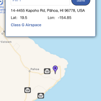
Bradshaw Field, the airstrip at Pōhakuloa, is shown properly, while the practice range boundaries did not appear when I selected a location on the Mauna Loa Access road where I planned to fly. I was within drone range of the PTA military restricted airspace and received no warning of that!
Doing an experiment I tried to plan a flight inside PTA airspace and the range boundaries finally appeared as a no fly zone in the app. Even if simply near a restricted area it would be nice to know!
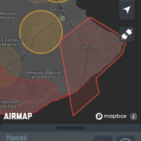
This TFR over the eruption is an official FAA TFR covered by NOTAM 8/3812, which can be read on the FAA website. Why is it not shown on the B4UFly map?!? There is even a list of active NOTAMS in B4UFly, NOTAM 8/3812 is missing from that list.
Local authorities are vigorously enforcing the no-drone restriction over the eruption area, having cited several pilots and seized aircraft. I wonder if they can use the lack of warnings in the official FAA drone planning application as a defense in court?
I have sent feedback on the FAA website on some of the most glaring errors in the B4UFly application. I expect I am not the only one, will the errors get fixed? I have no expectations there.
AirMap has another great feature, it is not restricted to US airspace, but handles other countries as well. As I am planning to fly along the British Columbia coastline this month I have had to familiarize myself with Canadian drone rules and insure I can check airspace. AirMap fulfills that need.
My recommendation? Load and keep both on your mobile device to check if a question arises. In general AirMap is far more complete, reliable, and far more usable.

Did u get some floats for da drone? Just in case u have a water landing?
I hope u are havin fun
Aloha
Hi Andrew-
One thing I’ve wondered about the drone I’ve not seen you mention is performance at altitude. Do you notice any difference between use at sea level or up at elevation on Mauna Kea?
-Dean
Agree that B4UFly is not good. Even some super basic no-no’s do not appear, never mind the TFR’s.