
Seymour Narrows is a bit of water one approaches with caution. This narrow passage north of Campbell River provides the shortest route between Vancouver Island and the mainland for transiting vessels. This passage is also subject to dramatic tidal currents of up to fifteen knots.
The strong currents create large areas where the water seems to boil, dotted with whirlpools and debris swept along by the rushing water. The result is what explorer Captain George Vancouver described in his logs as “one of the vilest stretches of water in the world.”
The passage was once much worse, a large rock named Ripple Rock lurked just under the surface at low tide. This mid channel rock created huge standing waves and vicious eddies as the current ran over it.
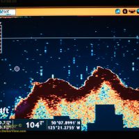
Knowing the history of the rock I wanted a look at the remnants for myself. The Nordic Quest’s sonar provides a very nice look at the bottom. Thus I switched to high frequency mode and steered the boat directly over the site of Ripple Rock as indicated on the marine charts.
And behold, the rock did appear. The profile revealed by the sonar agrees quite nicely with what one would expect. A set of peaks at the reported depths, with what could easily be the remnants of the blast craters. I took some photos of the resulting sonar images to record what I found.
What is left of Ripple Rock no longer poses a threat to passing vessels. Still, Seymour Narrows demands respect, even without the rock the raging currents and whirlpools are best avoided by waiting for slack tide as we had.
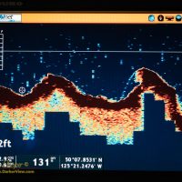
I suspect I just found one of the many wrecks known to have occurred in the narrows. At least 20 large vessels, and over 100 small vessels, have been lost here. The object I spotted is substantial, providing a strong return. I considered a sunken tree, but this is too large, it looks like a wreck to me.
Just a bit of historical fun. A bit that most of the thousands of people who pass the narrows never notice.

Pretty cool video dude. A blast and a half lol. See if u can find the nuclear blast video that removed Kawaihae. That would be a cool video.
Aloha
The Kawaihae blast was big, but was created by conventional explosives. The myth began as the harbor blast was partly the work of a military research group that was studying the effects of large explosions, including nukes.
Ahh Haa! I knew you would ha e the corect answer!
Aloha