
After two weeks of being stuck at home I really wanted to get out and stretch my legs. A hike is in order.
The governor specifically allows outdoor exercise in his stay-at-home order, including “surfing, swimming and walking pets”. I took that to cover a local hike near home. Just outside Waikoloa Village are quite a few rough roads that allow access to big areas of land, much of which belongs to the village association.
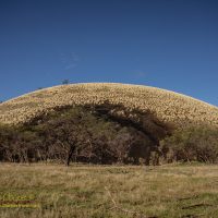
Puʻu Hinai would be my destination, a prominent landmark that sits 200 feet above the surrounding plains, a feature that I have seen on every commute for 13 years and wondered what was out there. A short walk of about a mile off of Waikoloa Road it was an easy target.
A large part of the puʻu has been carved away by a cinder mining operation. A decade ago trucks carrying cinder were a common sight on Waikoloa Road, no longer, the quarry lies abandoned. The side of the puʻu that faces the road is mostly untouched. The far side? It appears much is gone, I wanted to see just how much.
A beautiful sunny morning saw me hiking out the gravel road to the puʻu, still early enough to be nicely cool, it would get hot later.
Goats. Did I mention the goats? There are hundreds upon hundreds out there. I ran across small herds every few minutes and could sometimes hear bleating in multiple directions. One herd nearly walked right into me as I sat flying the drone. I let off the drone controls to pick up a camera to fire a couple frames of their surprise.
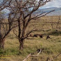
There were goat trails everywhere, I often used them to cross the rough terrain. Goat scat everywhere as well and I found two dead goats, one by smell.
The puʻu itself is a geology textbook lesson to an observant eye. I could see signs of the eruption process, of mass wasting over the intervening millenia since it erupted. The texture and color of the cinder differed, with coarse cinders on the eastern side and fine cinder on the west, likely a result of the trade winds sorting the airborne tephra.
Much of the puʻu is black cinder, very black. In contrast the western summit is made up of red cinders, a massive hundred food high bright red cliff created by the cinder pit operations exposes this deposit.
Puʻu Hinai is an example of the Laupahoehoe Volcanics, representing the last eruptive cycle of Mauna Kea. The Laupahoehoe Volcanics date from around 70 thousand years ago to the last eruption on the mauna 4,400 years ago. I suspect the puʻu dates from the more recent end of that age range, something between 10-20 thousand years ago along with most of the surface lavas on the west flank of Mauna Kea.
Along with the cinder cone rising above the vent Puʻu Hinai was the source of a short lava flow that flowed several miles down the slope to well below Waikoloa Village. This flow can be seen in the first mile of Waikoloa Road makai of the village starting at Quarry Road where the dry forest sign is.
The puʻu stands a bit over two hundred feet above the surrounding grasslands. It was once a bit higher, but it appears the cinder mining removed the highest point on the south rim, where the large gap is now.
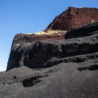
Arriving on the south side of the puʻu one can see that about a third of the puʻu has been carved away by cinder mining. Tall cliffs of cinder expose the inner structure of the puʻu. Several terraces are carved deeply into the cinder.
I had expected the cinder quarry to be dangerous to approach, with tall unstable cliffs to avoid. I was surprised to find that is was fairly safe to climb the puʻu on what appeared to be an access road carved by a bulldozer leading up the terraces and through the breach into the crater. It was a short stiff climb to the top of the puʻu.
On top the view was magnificent, to the south Hualalai stood in the sun, to the north Kohala sat under forming thunderclouds. Mauna Kea was mostly obscured by clouds, but otherwise the view was blue skies and an even bluer ocean below.
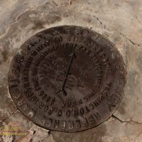
To my surprise I found a benchmark atop the puʻu, a US Coast and Geodetic monument dating from 1967. No elevation was marked on the benchmark, but the topo map noted the elevation at a bit over 1,400ft above sea level.
Atop the puʻu I slipped off my day-pack and munched on dried bananas and cold iced tea. I set up the drone for another flight. This was just a nice day to get out of the house, tomorrow back to staying home and avoiding the virus.

Interesting write up of your hike Andrew. I love the Drone photos.