
The aircraft is rather unremarkable, a standard small jet sitting among many similar aircraft at the Kona airport. It is the NASA colors and the odd pod hanging underneath that belies that this jet is somewhat unusual. This aircraft does not shuttle passengers across the country, it is home to a unique instrument called UAVSAR.

During this deployment the aircraft has quartered the Big Island, mapping any changes in the landscape on this volcanically active land. The acronym UAVSAR stands for Uninhabited Aerial Vehicle Synthetic Aperture Radar. As the name implies the system is designed to operate from a UAV, but it is currently installed in a crewed Gulfstream III aircraft.
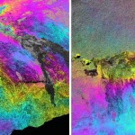
For this mission it is this volcanic island that is the target. As any islander knows we live on a rock that moves. The island settles into the sea, slides into the ocean, and swells where magma pushes its way into the volcano. Each year they return to Hawai’i to re-map the island, this is the fourth year they have returned to check the changes wrought by the volcanoes.
The JPL/NASA folks have completed their mission to the island for the year. Our tour was the morning they were due to depart, flying back to the Dryden Flight Research Center in California.
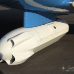
Hanging underneath the aircraft is the pod containing the radar itself. Bright white, the pod sports a flat antenna down the port side for the sideways looking beam. A trio of scoops on the front ram air through the pod to keep the electronics cool.
We chatted with the flight crew and the radar team learning about the instrument and aircraft. They travel all over the US and sometimes around the globe. They have mapped volcanoes in Alaska and Japan, glaciers in Iceland, measured oil spills, and scanned regions effected by major earthquakes. We noted that they had a fascinating job, while they said the same right back at us.
After the tour our hosts kicked us off the plane and began start-up for their hop back to the mainland. We got the data disks with the GPS data we needed for our tests and traded business cards and contact info. I will have to keep my eye out for the results of this year’s Big Island deployment.

Ok… now I see how you got the Wordless Wednesday photo.
Cool! Knowing me… I would have asked em for a ride!
The ride would have ended at Dryden Flight Research Center in California, minor problem getting a ride home after that;)