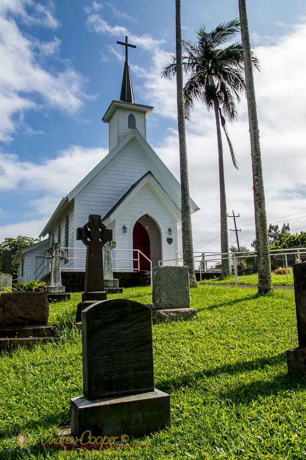
St. Augustine Church
When you want to see the stars, find someplace dark

Exploring the district of North Kohala
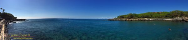
A perfect blue day at Māhukona, in a word… Idyllic.
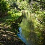
Floating down a century old irrigation canal is an excuse for a lot of photos. More than fit in the article that posted yesterday. I put a bunch more photos in a quick slideshow…
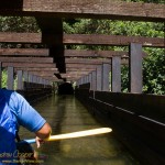
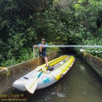
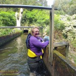
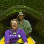
With the water conditions remaining poor for diving, it was time to consider some other activity for the Labor Day weekend. Recalling a news release from a few months ago I had an idea… Flumin’ Kohala.
Flumin’ Kohala offers two tours a day, an 8am tour and another at 12:30pm. I knew that the earlier tour was far more likely to offer clear blue skies and rain free conditions. In the afternoon the clouds often build along this coast, creating the rain that the irrigation canal is designed to collect.
This tourist attraction has been closed several times when the canal was damaged. The 2006 earthquake destroyed one flume and damaged others forcing the kayak tour to close. This was eventually repaired allowing tours to begin again. In early 2015 the canal was again badly damaged, this time by heavy rains and flooding, forcing tours to cease. After repairs the tour was restarted, this time by the ditch operator instead of contracted out. Thus the new company is locally owned and employs local residents. All of our guides were guys that grew up in North Kohala, full of information about the area.
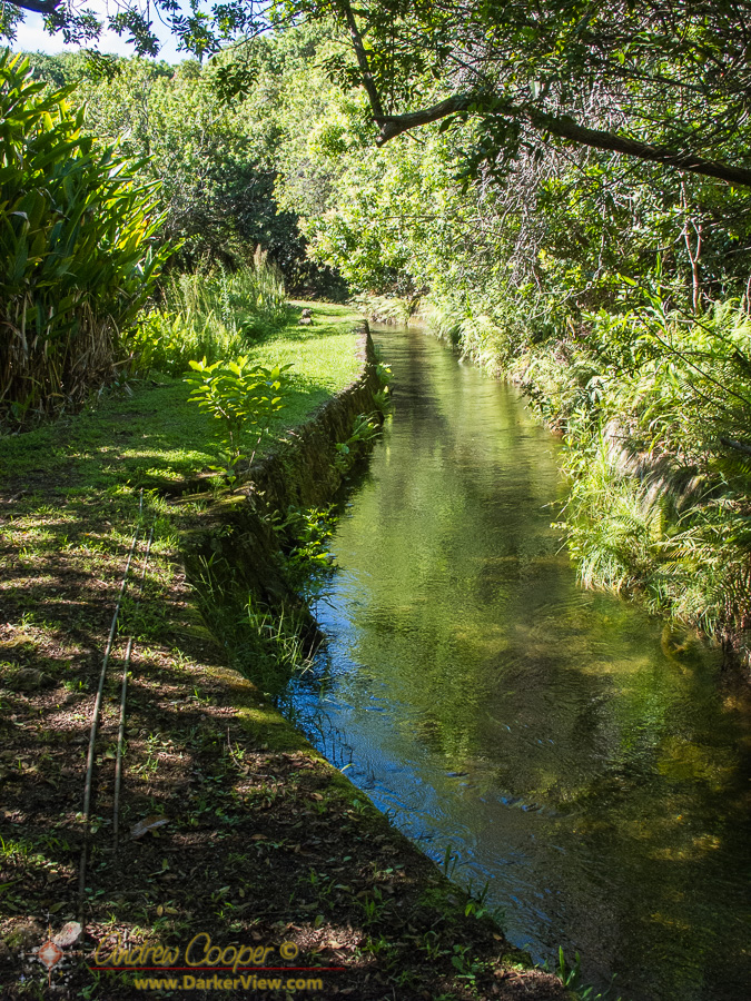
The water was used to irrigate thousands of acres of sugarcane and to supply the five sugar mills that once operated along the Kohala Coast. While sugar production ceased in the 1970’s the canal system continues to supply water to local ranchers and a nursery.
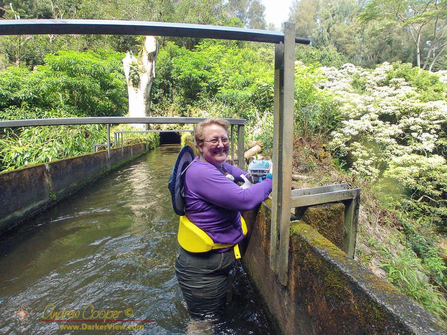
Today it is the employees of Flumin’ Kohala that maintain the canal system as well as providing tours. Repairing the old stonework, clearing debris and sediment from the ditch and pruning back the rain forest that would quickly overgrow the canal. Water level is maintained through a system of sluice gates that must be adjusted with the rainfall to let water out of the ditch where needed.
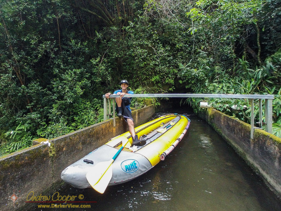
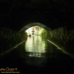
Midway we stopped an got out to enjoy the view from one of the flumes crossing a pretty gulch and waterfall. Of course there is no trail here, getting out meant we were standing in a couple feet of flowing water wading across a bridge. Usually one wades under bridges, not over them. Everything about this tour was definitely unique!
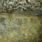
The laborers who carved and maintained the canal system left marks of their passing. In a few places Japanese Kanji characters can be found along the tunnel walls, preserved underground. Thousands of hand carved blocks of stone line the tunnels and banks of the canal, a testament to the craftsmanship of those who built.
As the website strongly warned us… You will get wet! We wore swimsuits under our shirt and shorts, good choice. I wore a set of hiking sandals, Deb a pair of scuba booties. For cameras I used the GoPro while Deb shot a G11 in the waterproof housing. My sturdy canvas hat was a good choice as well, protecting my scalp from the tunnel ceilings a few times. Wet we got! As recommended we brought towels and the Flumin’ Kohala office has large bathrooms set up for changing into dry clothing when you finish the tour.
I was expecting a fun day, Flumin’ Kohala was more fun than I expected. This was no short trip, the miles of canal and tunnels just kept flowing past. This is an adventure well worth the cost. Great guides and a fascinating experience provided just the thing for an otherwise quiet Sunday.
At some points there were half a dozen different groups of whales in sight at the same time. The spotters called whale activity in a confusing chorus of activity and locations. The annual Hawaiian Islands Humpback Whale National Marine Sanctuary Ocean Count picked a pretty good day. Given the recent winter storm I had half expected to be rained out, some of the east Hawai’i sites were, but we had perfect conditions.
Not that we always needed to look that far, often enough the whales were at the base of the bluff, just a few hundred yards below us. In one half hour data interval we counted 24 breaches. Just a few whales around.
No argument, it was a good morning to be counting whales. From the looks of the preliminary results, our site counted far more whales than any other site across the islands. No surprise, this stretch of coast is always thick with whales. The only sites that challenge MM7 are the sites just north and south, Lapakahi and Pu’ukohola Heiau, from the data those folks had a good day as well.
[dmalbum path=”/wp-content/uploads/dm-albums/Kohala Diving/”/]
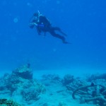
Heading north from Kawaihae there is some of the best diving in the islands. Most of the sites along this rugged coast northern are best dived from a boat. You can reach many from shore, but access can be tricky and a matter of knowing which 4WD road will get you to a usable put in point. There are a couple exceptions where access is easy, the best is Mahukona.
What you find here is a small port from the days when sugarcane and cattle were transported on small steamships that plied the waters up and down the Hawaiian Islands. A substantial pier and other facilities were built in a small cove to serve the north end of the island. A railway terminated here, allowing products to be brought in from much of North Kohala. Most of that is gone now, replaced by good roads, semi trucks and the large port at Kawaihae. What is left is a sleepy little cove with perfect water and great diving.
A steel ladder at the top of the wharf provides access right into the water. The access is simply the easiest I have ever used on a shore dive. No sand, no slippery rock, simply a parking lot at the waters edge!
Once you leave the pier head for the center of the harbor. You will quickly find several heavy mooring chains. Large and obvious these chains are heavily encrusted with coral, simply follow them out to the wreck of the Steamship Kauai. The wreck lies in 12-24 feet of water at the center of the harbor.
The engine and propeller are the largest parts to be found and are a little to the north of the large sandy area at the center of the cove. The propeller is in only about 12-15ft of water, accessible to snorkelers as well as divers. Connected to the propeller by the shaft is the large steam engine. This is less obvious when you first see it, but hard to miss once you know what it is. Closer inspection will show numerous pipes, control linkages and the large flywheel at the rear of the engine. Looking into the engine you can see the crankshaft and the numerous fish that find the engine a perfect hangout. Spend some time here, we have found a dwarf moray, blue dragon nudibranch and great fish at the engine.
Scattered out from the engine is a great deal of other evidence of the wreck. The steamship had a cargo of agricultural products and railroad parts when it sank. You will find quite a few wheel sets for narrow gauge rail car use, one is under the engine, others in the middle of the sandy area just seawards of the engine. Cables, piping and ballast bricks are everywhere. A boiler can be found on the north edge of the sandy area, about 4ft in diameter and 12ft long. Check inside to see who is home.
We found three different species of moray eels here, good fish and healthy coral. Not many large fish, fishing and spear hunting is allowed in the area. The small fish area very numerous with large numbers of fry int the shallows and around the wharf.
Mahukona is just about the perfect shore dive site. Park on the pier, and just drop your gear in the water. Shallow diving unless you head out of the cove, but a lot to see in the harbor, you may never make it any further. This site makes for a long shallow dive exploring a little local history.
Most of the Kona side dive operations operate out of Honokohau Harbor, giving access to dive sites from Kailua Bay to well north of the airport. These are the operations most divers visiting the Big Island are familiar with. The diving is good around Honokohau, but can be limited, island divers know that the character of the reef is different as you move north or south.
Experienced divers will often recommend diving the Puako and North Kohala reefs. Here the shoreline is notably older, where the volcanoes have not sent lava flows into the sea for many thousands of years. The reefs have had much longer to establish themselves, resulting in heavier coral growth and rich sea life.
If you want to try the sites further north, along the Kohala Coast, you need to choose another outfit to dive with. Two local dive ops operate along the Kohala coast, Blue Wilderness and Kohala Divers. Both outfits are small businesses, locally owned and operated, the owners often on the boat with you.
My March project is to move all of the dive guide articles over from the old blog. Most of them are already moved over, scheduled to post through this month. Copied and pasted over from the old blog, I have gone through them and updated the posts with current information. The series of blog articles provides a nice guide to anyone exploring the Kohala coast with the plan of getting in the water to snorkel and dive.
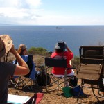
It is that time again! Time for Ocean Count 2012… A morning spent spotting and counting whales for the Hawaiian Islands Humpback Whale National Marine Sanctuary.
The sanctuary staff recruits teams to crew sites all around the islands. All together, 61 teams with over 950 volunteers observed whales from Kauai to Hawai’i today. Twenty one teams set up to cover the Big Island from South Point to Opolu Point. The procedure is to observe whales from 8am to noon, recording the behavior in half hour time slots. Every blow, dive, breach or other activity is recorded. The technique is to work in teams of two, one person spotting, binoculars in hand, the other writing as the whale activity is called out.

A bluff overlooking Pelekane Bay has been our site for the last three years. Mile Marker 7 is a perfect place to observe whales. A bluff well above the water. A rocky knoll covered with lawn chairs, coolers, and well over twenty observers peering through binoculars.
This year was much like the last several years. We counted dozens upon dozens of whales from the MM7 site, while other sites around the island are lucky to see a handful. There are some sites that did not see a whale all day. We count as fast as we can write, activity everywhere.