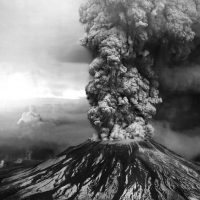
Living with an eruption of our local volcano through much of last year often brought to mind previous memories. The 2019 Kilauea eruption was the second eruption of my life, the first being the 1980 eruptions of Mt. St. Helens.
The eruption of Mt. St. Helens taken on the morning of May 18th, 1980, photo credit USGS
St. Helens was just another of the pretty mountains that dotted the horizon through much of my childhood. I could see it from my bedroom window, at least in the winter when the leaves were off the trees.
When the mountian started rumbling in the early months of 1980 everyone wondered if it will erupt. No one expected it to do what it did.
We did not hear the eruption, somehow the sound skipped over those nearer the volcano. It was the television news that first alerted us.
Seeing the reporting I ran out of the house and down the street a little bit to where I could see past the maple trees. There was nothing to be seen of that pretty mountain, just a dark line in the sky rising from where the mountain stood. West of the line it was a cloudy NW sky, east of the line is was just black.
After the eruption we could no longer see the mountain on the horizon, with 1,500ft gone from the top it no longer stood above the ridgelines.
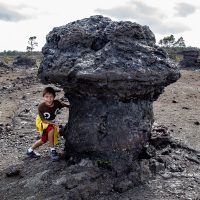
Hawaiʻi Volcanoes National Park reopened to the public at the end of September. Reshaped by the eruptions the park has substantially changed since I was last there back in February. It was well past time I got myself out to the park to see the changes, it had been open almost two months!
Julian examines a lava mushroom near the 1969 fissure on the Mauna Ulu trailI had resolved to go over the long holiday weekend. An additional idea occurred to me, if I was going, why not kidnap my young nephews along for the trip. We would leave the gals to whatever they will do, and go have an adventure.
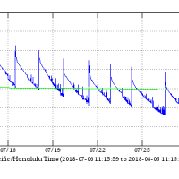
When will this eruption end? The answer to that is a question many are asking on this island. Today we might just be seeing the answer.
Tiltmeter data from the summit of Kilauea, as of 5 Aug, 2018 over the past monthReports and photographs from the eruption zone show a greatly diminished fissure 8, a mere shadow of the lava fountains visible a month ago. The once vigorous lava channel is now sluggish and crusting over in places.
We are now more than two months into this new eruption from Kilauea. Two months ago the fissures opened in the Leilani Estates subdivision and homes began to burn.
The lava fountain at fissure 8 in Leilani Estates throwing lava hundreds of feet in the air on June 4th, 2018For two months this slow motion catastrophe has continued. While a major earthquake may be over in minutes, or a hurricane over in a few days, this eruption just goes on. For the folks in lower Puna the lava continues to destroy homes and disrupt lives.
For those of us outside the eruption zone things are not quite as immediate. We read the daily news, peruse images of helicopter overflights each morning, and wonder when it will be over.
The multiple county civil defense status reports and various emergency alerts that pop up on our phones each day provide current information… A bit of the Mamalahoa Highway has collapsed in Volcano Village with a one lane restriction, the road to Kalapana has re-opened, there is no tsunami threat from that last 5.4 magnitude earthquake.
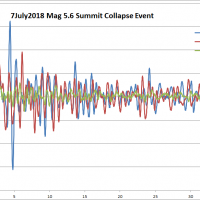
A plot of the July 7, 2018 summit collapse earthquake as recorded by an accelerometer in the Keck Observatory foundationEvery day is punctuated by a magnitude five point something earthquake. These summit collapse events have become very regular. You can guess when they will occur as the frequency of small quakes increase around the caldera.
For the most part these events pass unnoticed by much of the island. The volcano area gets shaken up pretty well, but these fifth magnitude quakes are often not felt very far beyond that.
On the summit of Mauna Kea these daily quakes often do disturb the telescopes at night, bumping the tracking and ruining exposures, but otherwise too weak to cause any damage to the facilities.
Hualālai peeks over a thick layer of volcanic smog, or vogThe most significant island wide impact has been the vog, wreathing the island in a sulfurous haze. Sulfur dioxide pours from the active vents, mixes with water in the air and forms a thick brown grey haze.
When the vog is bad you not only see it, you smell the sulfur, it irritates eyes and nasal passages. Fire and brimstone reaches out to touch us all.
While the vog makes for spectacular sunsets, the vog can also be thick enough to curtail outside activity. A day like today, with brisk trade-winds to clear it away, is a welcome relief.
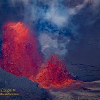
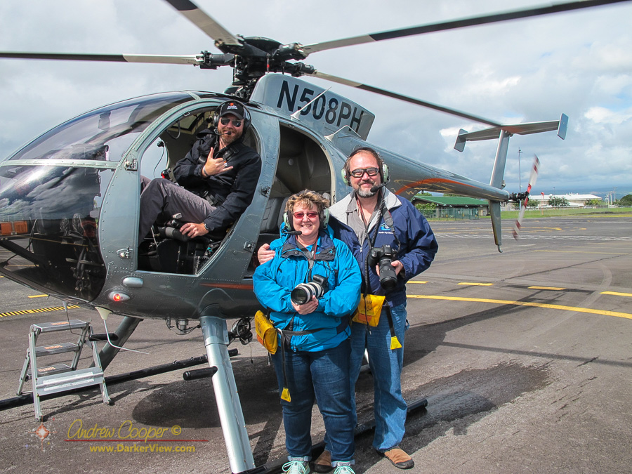
The lava fountain at fissure 8 rising about 250 feet as this Kiluaea eruption continues unabated.Opportunities to legally witness this eruption are few, authorities have been enforcing the evacuation area increasingly strictly. Legal options are the fly or float to the eruption. Deb and I chose to fly a month ago, a helicopter flight I am sure we will remember for a lifetime.
I have not attempted to go to photograph the lava river, despite a very strong desire to do so. The county and state have repeatedly talked about opening a lava viewing area. while there is a great deal of pressure from the community, so far nothing has materialized.
We are so ready for this eruption to be over.
Given the collapse of the summit caldera and the enormous volume of lava emitted so far, it may be possible that when this is over there will be no further eruption for a while. It may take a while for the volcano to recharge, perhaps a year or two. Will we return to the pattern of intermittent eruptions that was seen through much of the 20th century?
One of the most poignant scenes we witnessed was the many farms destroyed by the lava
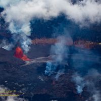
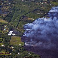
The front of the fissure 8 flow approaches Kapoho BayWe took our helicopter ride Sunday morning, June 3rd. At this point the large flow from fissure 8 had not yet reached the neighborhoods at Kapoho. What the flow was burning through were the many papaya orchards and flower growers found above the bay.
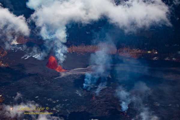
Houses are bad enough, seeing the farms in front of the lava flow was worse. I found myself looking through the telephoto lens at the neat greenhouses, the orchards green in the morning sunlight. The wide flow front was in the process of destroying so many farms, remorselessly moving through the neat rows of papaya trees.
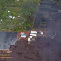
The greenhouses of Orchid Plantation Inc. disappearing under the lava.I am aware of how much a farmer puts into the land… Sweat, blood, heart and soul. I look at the photos and I see immaculate operations… Well maintained buildings, no weeds around the structures, the pitiless lava flow advancing. Each scene that appeared in the camera viewfinder was gut-wrenching.
How to get a good look at this eruption? Not a trivial question. The neighborhoods involved are under mandatory evacuation orders enforced by police and National Guard checkpoints. Quite a few people have been arrested and cited while trying to get closer to the lava.
The lava fountain at fissure 8 in Leilani Estates throwing lava hundreds of feet in the air on June 3rd, 2018
This is the first major change in the eruptions of Kilauea in decades. This eruption features phenomena seen in the old documentaries, lava fountains hundreds of feet high, huge flows cutting through the rainforest. Things I have always wanted to see.
As much as I would like to visit, we have simply not tried to get into lower Puna. It is just not pono to interfere with residents frantically trying to salvage whatever they can ahead of the flows, or emergency services already overburdened with the ongoing situation.
Two legal ways exist for visitors to get a closer look… Fly or float. Either take a helicopter ride over the eruption, or take one of the lava boats to an ocean entry.
The boats have resumed tours, but active ocean entries have been sporadic, running for a week, then stopping. As of Monday morning the lava has re-entered the ocean at Kapoho Bay, and is again view-able from the water. The boat runs also involve a fairly long run all the way from Hilo harbor. The boat ramp the tours once used at Pohoiki now cut off by the flows.
While much of the attention is on the lava flows and burning homes in lower Puna, there have been dramatic events at the summit of Kīlauea. The pit crater of Halemaʻumʻau that has been the subject of untold thousands of tourist photos has become almost unrecognizable.
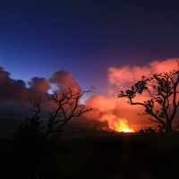
The plume of volcanic gasses from Halemaʻumaʻu under the starsHalemaʻumʻau is a pit crater created by the ever changing eruptions of Kīlauea. Half a mile across, this crater sits within the much larger Kīlauea caldera at the summit of the volcano. A nearly circular pit that lies at the center, home to many eruptions across the centuries. This often fiery pit is reputed to be the home of Pele, the goddess of fire and creation in Hawaiian mythology.
Step outside and you can smell the sulfur… In Waikoloa!
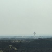
The Kona airport wreathed in vog on May 29, 2018This is a first. The vog has been bad, but never this bad, the entire island is wreathed in a heavy haze of volcanic emissions. As I write this I feel my eyes are irritated, stepping outside you can see it in the streetlights.
Deb and I drove to Kona this afternoon. The usually pretty drive was simply gray, gray with a tinge of yellow-brown. No views of the mauna, no views of the ocean. You could barely see the airport from the highway as we passed.
The vog has been the subject of conversation everywhere, online in social media, and in every single casual conversation you happen into today. The volcano, so devastating to those in lower Puna, has reached out to touch us all.
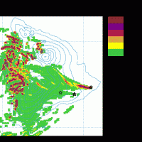
Vog map May 29, 2018The vog mapping done by the University of Hawaii showed that mid-day, the vog was sweeping right through the Saddle at Waikoloa and the Kona coast from the current eruption site in lower Puna. Fortunately the predictions are for resumed northeast trade-winds tonight, clearing much of the island of vog into tomorrow.
Things could be worse. An explosion at the caldera today showered surrounding communities with ash and Pele’s hair. Plus, there is much to be said about not having a lava flow, or three, flowing though your neighborhood.