Lava Fountain
When you want to see the stars, find someplace dark

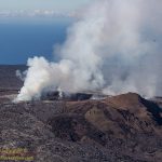
While much of the attention is on the lava flows and burning homes in lower Puna, there have been dramatic events at the summit of Kīlauea. The pit crater of Halemaʻumʻau that has been the subject of untold thousands of tourist photos has become almost unrecognizable.
Step outside and you can smell the sulfur… In Waikoloa!
Deb and I drove to Kona this afternoon. The usually pretty drive was simply gray, gray with a tinge of yellow-brown. No views of the mauna, no views of the ocean. You could barely see the airport from the highway as we passed.
The vog has been the subject of conversation everywhere, online in social media, and in every single casual conversation you happen into today. The volcano, so devastating to those in lower Puna, has reached out to touch us all.
Things could be worse. An explosion at the caldera today showered surrounding communities with ash and Pele’s hair. Plus, there is much to be said about not having a lava flow, or three, flowing though your neighborhood.
I understand that some of our family can be a bit fuzzy on island geography. We have had a few exchanges with family members over the last couple days where we have had to remind them that we live on the other side of the island from the volcano. Yes, we are just fine and in no danger from the new eruption.
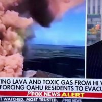
Like Fox News.
At least our family members understand the difference between Hawaiʻi Island and Oahu. But a national news network? I guess that to many Oahu is Hawaiʻi, rather in the same way that Los Angeles is California. Shall we just ignore 230 miles of Pacific Ocean and a few other islands in the way.
Yes, Deb felt the earthquakes in Waikoloa, but they were not bad. There was not even a broken glass at the house despite a magnitude 6.9 earthquake at the the other end of the island. We are 65 miles and two very large mountains away from the volcano.
I was at work and experienced the earthquakes at the summit. Mag 6.9 is now my personal record for strongest earthquake felt, I really do not need to feel anything larger.
While we are safely away from the new lava flows, there are many who are not. It is hard to describe my emotions when seeing video of a house burning as the lava pushes through. Nicely kept gardens surrounding the house betray the effort and pride of the home owner. You can feel dimly the shattering loss of a home and everything that goes with it.
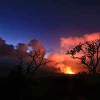
The volcano is up to something.
This morning began with a series of strong earthquakes along the eastern rift zone of Kilauea. The island was buzzing about it, the local news, social media, it was the main subject of conversation in our trucks headed to the summit. By this evening there have been over 250 earthquakes, including many of 3rd and 4th magnitude, along the rift zone, a clear sign of lava moving underground.
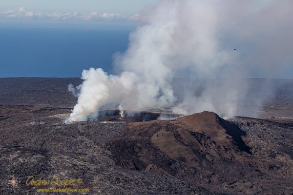
The increasing pressure has raised the level of the lava lake at Halemaʻumaʻu to the point of overflowing into the larger crater multiple times over the last week. This alone can be spectacular as it is easily viewed from the viewpoint at the Jaggar Museum in Hawaii Volcanos National Park.
The tour guides give the basic story behind the creation of Mauna Kea. The story given is simple… A hot spot in the mantle is the source for a plume of magma that punches through the oceanic crust and forms the Hawaiian volcanoes. As the pacific plate moves the islands are formed one by one, the latest being the Big Island of Hawaiʻi.
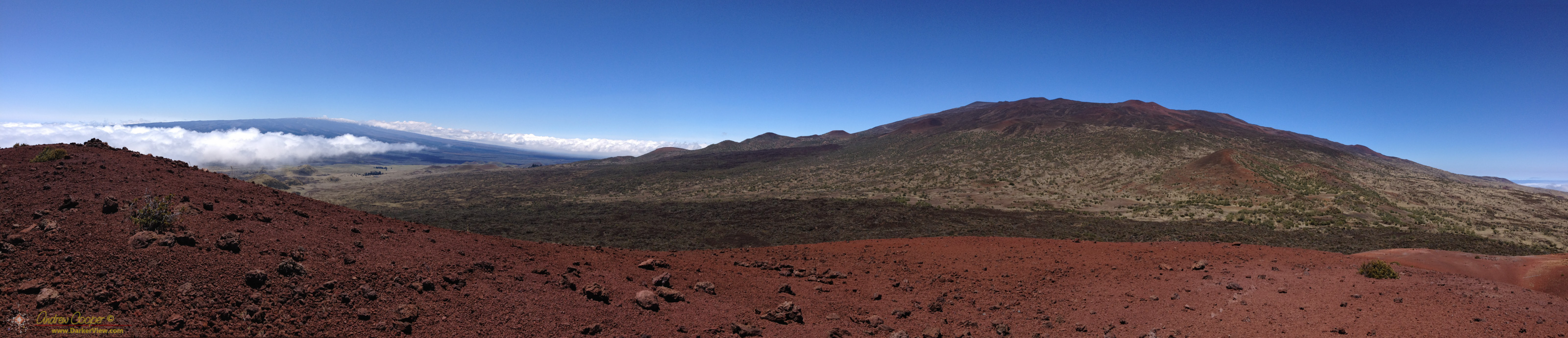
Fortunately there is a good source for answers… The Geology and Petrology of Mauna Kea Volcano, Hawaii —A Study of Postsheild Volcanism, Edward Wolfe, William Wise, and G. Brent Dalrymple. This seems to be the definitive paper on the geology of Mauna Kea. Any time I see a list of references for the geology of the mountain, this paper appears. Published in 1997 it incorporates much of the earlier studies on Mauna Kea into one compendium.
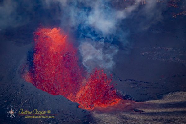
A helicopter ride over an active volcano… With no doors.
In mid-July deb and I took a helicopter flight over Kilauea with Paradise Helicopter. A lot of fun! I took all of the material we shot in our helicopter flight and assembled as a bit of video. A lot more view-able this way, more fun than a pile of images sitting on a disk.
On the other had I think I discovered all of the things that can go wrong when shooting from a helicopter with no doors! The wind and vibration is rough, making even the wide angle video of a GoPro jump about. Video shot on the DLSR’s was useless. I also discovered that helicopter blades passing in front of the Sun gives the GoPro Hero 4 Black exposure fits, with black ripples in the image. Thanks to image stabilization and fast shutter speeds the still photos are fairly good.
Seated in a steeply banking helicopter with nothing between me and the molten lava a couple hundred feet below is a thrill I will not soon forget. You can smell the sulfur and feel the heat. Hopefully a little of that comes through in the video.
No Doors from Andrew Cooper on Vimeo
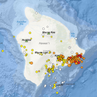
Being an inveterate volcano watcher, I have not only been watching the new flow on Kilauea, but keeping a wary eye on Mauna Loa as well. The USGS has steadily been increasing the alert level on this largest of the Hawaiian volcanoes over the last year.
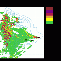
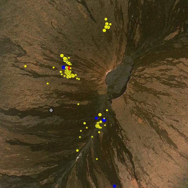
On this unstable rock we live, we get a fair number of earthquakes. Of course not every bump you feel is seismic, sometimes it is just a big truck on the highway. You look on the USGS Recent Earthquakes page anyway, just to see what it was. Not this time, must have been a truck. While I have the page loaded I look about… Wait? What is that cluster on the NW flank of Mauna Loa? I do not remember seeing that before!
For the last year or more there has been a steady cluster of small earthquakes just to the southwest of the main caldera. This notable cluster is usually visible when you stop by the earthquake page and indicates magma motion below the summit. It is a big part of why the USGS has upped the advisory level. The cluster on the west flank looks new to me, a lot of small quakes, some deep, some as shallow as 600m.
I am sure someone over at the USGS is looking at the same cluster and asking the same questions. Maybe they have better answers, but they have not published anything yet. Maybe, like so many times before this cluster will fade away, not to appear again. It is however a reminder that magma is moving down there, the mountain is swelling, someday she will erupt again.
Today I will be driving up and down the mountain. I know I will be looking across the saddle at the looking bulk of Mauna Loa and wondering for the thousandth time. Will I see an eruption from her during my years on island?
I had promised Deb a helicopter ride months ago. It is about time to deliver on that promise. Just waiting for the volcano to do something interesting. Will a new lava flow work?