
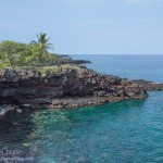
A few hours free in Kealakekua… What to do. Drive down the Puʻuhonua O Hōnaunau National Historic Park? Why not? Have camera will travel.
My goal was not to visit the sanctuary itself, I have been here several times. Instead, my plan was to walk the 1871 trail south along the shore, something I had never had a chance to do. I did start at the sanctuary, passing through and shooting a few photos of Kiʻ i before heading south.
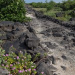
The trail is what was called a two-horse trail, wide enough for two horses to pass with room to spare, about eight feet wide. A curb of stone runs along both sides, while the roadbed between is cleared of rock and sometimes filled with sand or gravel to level the worst pits. In places the trial is built up to cross low areas with substantial stonework. The result reminded me in many ways of Roman roads in Europe, built to a similar pattern and cutting straight across the landscape.
On both side of the trail there are numerous remains of the ancient settlements. Stone walls and raised platforms reveal what was once a thriving settlement along the shoreline. There is the foundation of John Ahu’s house, complete with a cistern and an old grave. The remains of the ʻŌmaʻo Heiau, a hōlua slide and more are alongside the trail as you proceed. Ask at the visitor center desk for a guide to the various points of interest along the trail.
About halfway the trail is built against a small sea cliff. A large stone ramp was constructed to allow travelers to ascend the cliff. The amount of stonework serves to highlight how much work went into building this coastal access trail.
The south boundary of the park is a mere 0.8 mile along the trail, an easy stroll. Perhaps add a couple points of difficulty for the rough, rocky nature of the trail. It takes about half an hour to reach the abandoned fishing village. From there the trail continues south, out of the park. It becomes substantially overgrown, the path reduced to a cut through the brush with the occasional branch to push aside. I proceeded a bit further, but became rather annoyed with the amount of spider web I was accumulating.
As I sit amongst the abandoned stone walls of Kiʻilae Village it is interesting to imagine what the scene would have looked like a well over century ago in the 1870’s. A thriving settlement with travelers coming and going along the trail. Fishermen carrying their catch home, village women doing the chores and shopping, the tasks of life that never really change. Perhaps a royal procession going north to the temples at Puʻuhonua O Hōnaunau. The period was an interesting one, when western ways were mixing with the ancient patterns of life in the islands.
If you have some time while visiting Puʻuhonua O Hōnaunau, take an hour and walk the old trail. The scenery alone makes it worthwhile, with a bit of history thrown in.