Three days after we dove the site, a great white shark attacks a diver at the same site. The man was skin diving and spear fishing at O’oma, what the surfers call Pine Trees. The diver was not injured, the shark attempted to steal his catch and from the story might have escalated the attack if the diver had not gotten out of the water. Sounds like there were some photos taken of the shark from shore, but none seem to have surfaced yet.
Interestingly, the diver described the shark as injured, perhaps a reason the shark was attempting to grab an easy meal on the reef instead of the usual pelagic prey?
A little spiral on a rock, an odd looking thing, a bright white against the reds and yellows of the sponges. I spotted the spiral from some distance away across the cave. But I know what to look for, sweeping the rock with my dive light.
The nudibranch themselves are nearby, on the same face of the rock. I find three white-margin nudibranch, two quite large at about 3cm, the largest I have seen this species. A much smaller specimen is close by, less than half the length of the adult. These are a handsome species, always nice to find.
White-margin Nudibranch (Glossodoris rufomarginata) egg mass
I am surprised that the eggs are not quickly eaten by fish or other predators. There must be some defense mechanism in play, a foul taste, a toxin, nudibranch are known to employ such tactics.
A pair of White-margin Nudibranch (Glossodoris rufomarginata), 25ft depth at O'oma
Put your head below water near any tropical reef and the first thing you hear is the cacophony of snaps. This is the popping or crackling noise of hundreds of snapping shrimp. Rarely seen, these small shrimp are everywhere, I find it amazing that these small shrimp have such an impact on the reef environment.
This pair was deep in a cauliflower coral, not easy to photograph. Even worse, I was snorkeling, not diving, it took three dives, and three attempts to get the photo…
Lottin's Snapping Shrimp (Alpheus lottini) deep in a califlower coral head (Pocillopora meandrina)
At the very north end of the Mauna Lani resort complex, just beyond the gates into The Fairmont Orchid is a very nice public access to the coastline. With well maintained facilities, this park attracts local and tourists alike to the water. There are full bathrooms, a fresh water shower, picnic tables and barbecue grills to use amongst a rich lawn and pleasant shade trees. The coast here is a picturesque combination of blue water and black volcanic rock jutting into the sea. The parking is limited to a couple dozen spots just behind the park. The site can be used equally well by divers or experienced snorkelers with a rich coral reef just offshore the beach here.
The entry here is rough cobble and rock, care must be taken to scout a course through the many offshore rocks that complicate swimming to and from the beach. When the seas are calm, there should be little if any trouble getting to and from shore, do not attempt this area if there is any substantial surf to deal with.
View Larger MapGoogle map of Holoholokai Beach park, click on the markers and the course line for specific information.
Whitetip Reef Shark (Triaenodon obesus) in a cave at Holoholokai, photo by Deborah Cooper
Reaching the site is fairly easy, following signs to the beach and to the petroglyphs through the Mauna Lani resort. Turn into the Mauna Lani resort from the Queen Ka’ahumanu highway at the obvious grove of tall palms surrounding the entrance. A little over a mile across the lava flows will bring you to a large roundabout (traffic circle in American). Turn on the first exit from the circle, heading north through the condominiums and town homes. A couple miles more will bring you to the entrance to the Fairmont Orchid. Just before the entrance a right turn leads down a paved road to the park.
A Whitetip Reef Shark (Triaenodon obesus) under a ledge at Holoholokai
Once into deep water the snorkeling or diving is as good as anywhere along the Kohala Coast, the same reef divers can enjoy at the Puako sites just north. The depth remains quite shallow until about 50 yards offshore where a series of steps can be found, the first dropping to 15-25ft and another just past this dropping yet further. The vertical walls of these steps are rich in coral and life. The shallow step provides the best place for snorkeling, while divers will quickly head for deeper water. Eels, octopus and other rich marine life are all to be seen here.
There are several very nice caves for divers here. Trending south from the entry area, one will encounter a surge channel in the coral. Two nice caves are found along this small canyon. The better of the two is on the north side where a low entrance at the base of the wall leads to a 40 foot diameter chamber with a large skylight. Sleeping white tip sharks are common in the caves and overhangs here, particularly first thing in the morning.
The parking lot also serves as a trail head for a three-quarter mile walk to the Puako Petroglyphs, a large collection of ancient Hawaiian rock art that is found in photos and guidebooks all across the islands.
Holoholokai makes for a nice beach experience with a pleasant park and good access to the water. Worth considering if looking for a place to get to the water amongst the resorts of the Kohala Coast.
The storms seem to have passed, the swell subsided, time for another dive.
While the invitation was extended to all of our usual crew, Pete was the only one to accompany us for the day. A small dive party this time, no problem, the arrangements were a little last minute. Some swell was forecast so we headed to a sheltered spot, End-of-Road, Puako.
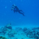
Pete enjoying a dive at End-of-Road, PuakoWith our tanks in for hydrostatic testing it was necessary to rent a pair for the day. No problem, just rent a couple tanks at Kohala Divers for the day. They always have tanks available for walk-in business. Worse yet, we have to return them, and they are just downstairs from Kohala Burger and Taco for an after dive lunch. Inconvenience all the way around.
Conditions at End of Road were fairly good, a bit choppy perhaps, but no current in the cove. Visibility was OK, but not great, a little bit of murk floating in the water from the swell. Having not used the End of Road site lately, we followed the usual plan, cut north out of the cove to drop into the first couple canyons. The goal was a long, relaxed, shallow dive to explore the caves and canyon walls.
I came across nothing new or spectacular on this dive. There were sleeping turtles everywhere in the caves, we found at least a half a dozen. A big moray met me face to face in one crevice. A nice weekend dive, another 80 minutes spent underwater.
The battery compartment on my strobe flooded. When I realized this I quickly surfaced and removed the batteries. At least the compartment is sealed from the remainder of the unit, thus there was little harm. The rechargeable AA NiMH batteries themselves are likely toast, with electrochemically corroded contacts.
Without the strobe I did use a small LED flashlight to illuminate some targets for photography. But the beam was much too narrow and concentrated. Perhaps a small modeling light is in order, something with a bright, but broad beam that can illuminate a target one or two feet in front of the camera. This would be great for cave and night diving, also providing a backup.
Deb and I are off for the week. I had to use up some vacation time, Deb is on spring break from the school. Our tanks have passed hydro and are ready to pick up. I expect another dive in our near future.
Possibly one of the best dive sites in the islands and certainly a favorite with local divers. The reputation stems from two factors, great diving in interesting terrain and easy shore access. The diving here can range from acceptable to spectacular with stunning water clarity and spectacular views of the coral.
View Larger MapGoogle map of the Puakō End-of-Road dive site, click on the markers and the course line for specific information.
Just north of the cove where you will enter, there is a series of deep canyons into the coral. These start near the surface in 6-10ft of water and descend to 25-30 ft. The result of the canyons are a range of vertical coral walls that reach from near the surface to depths of 20-40ft. At the head of several of the canyons are a series of arch caves and skylights to explore. You can just make out this cave on the Google map at right, just into the reef from the marker.
A canyon wall at Puakō End-of-Road dive site with Yellow Tangs (Zebrasoma flavescens) and Raccoon Butterfly Fish (Chaetodon lunula)
In our favorite cave a large arch leads into a wide cavern with a skylight. A second arch leads to a smaller cavern, and so forth until they are too small to enter. Look into the side ledges and caves for squirrelfish and sleeping turtles. Much of the interesting diving is shallow allowing for long dives. If you want to go deeper just swim out further from shore as the reef continues to descend.
Reach this site by driving north from Kona on the Queen Ka’ahumanu Hwy to the Puakō turn off. Drive down the main road through town, mostly just homes along the beach, for about three miles to reach the end of the road. The beach access is on the right about 100yds before the road ends in a locked gate to a private estate. The parking area is easy to spot as it will be busy with other divers and locals enjoying the beach. There is a fair amount of space but this place can get busy later in the day, particularly on a weekend. Park under the trees just a few feet from the water, you should not have to carry your gear very far. The map at the right should give you the right idea.
The entry at End-of-Road, Puakō
Most divers enter from the rocks or use the slot into the rock at the north end of the cove. From here you need to swim to the center of the cove over shallow rock and coral (4-8ft) to go around a shallow bar that juts out from the north shore. Once over the bar bear to the north to find the canyons across coral at 10-15ft. A little swim, but very scenic snorkeling along the way.
Avoid use of the site if there is substantial surf across the bars at the north and south side of the cove. These create a stiff outwards current at the center of the cove that can be difficult to negotiate getting back to shore. Just look for the surfers! If they are happy and surfing nice waves, a diver will not be happy.
End-of-Road is a good dive site to consider if the more exposed sites further north or south are problematic with a large swell. The region from Waikoloa to Kawaihae is some of the most sheltered coastline on the island. We often head here during the winter for shore diving, leaving sites like O’oma or Mahukona for the calmer days.
Heading north from Kawaihae there is some of the best diving in the islands. Most of the sites along this rugged coast northern are best dived from a boat. You can reach many from shore, but access can be tricky and a matter of knowing which 4WD road will get you to a usable put in point. There are a couple exceptions where access is easy, the best is Mahukona.
What you find here is a small port from the days when sugarcane and cattle were transported on small steamships that plied the waters up and down the Hawaiian Islands. A substantial pier and other facilities were built in a small cove to serve the north end of the island. A railway terminated here, allowing products to be brought in from much of North Kohala. Most of that is gone now, replaced by good roads, semi trucks and the large port at Kawaihae. What is left is a sleepy little cove with perfect water and great diving.
Deborah exploring wreckage from the SS Kauai at MahukonaThe area is a county park used by locals and the few tourists that venture this far north. Camping is allowed by permit and there are some facilities, but maintenance is a little scarce. The large concrete wharf is in decent shape and allows parking right at the water. Do be aware of boat traffic, this is still a harbor. Power boats are unusual here, it is a long way to any boat launch, but we have seen one come into the harbor… once. The usual traffic here are the many kayaks and rowing canoes that use Mahukona as a put-in or pull-out point.
A steel ladder at the top of the wharf provides access right into the water. The access is simply the easiest I have ever used on a shore dive. No sand, no slippery rock, simply a parking lot at the waters edge!
View Larger MapGoogle map of the Mahukona dive site, click on the markers and the course line for specific information.
Once you leave the pier head for the center of the harbor. You will quickly find several heavy mooring chains. Large and obvious these chains are heavily encrusted with coral, simply follow them out to the wreck of the Steamship Kauai. The wreck lies in 12-24 feet of water at the center of the harbor.
The engine and propeller are the largest parts to be found and are a little to the north of the large sandy area at the center of the cove. The propeller is in only about 12-15ft of water, accessible to snorkelers as well as divers. Connected to the propeller by the shaft is the large steam engine. This is less obvious when you first see it, but hard to miss once you know what it is. Closer inspection will show numerous pipes, control linkages and the large flywheel at the rear of the engine. Looking into the engine you can see the crankshaft and the numerous fish that find the engine a perfect hangout. Spend some time here, we have found a dwarf moray, blue dragon nudibranch and great fish at the engine.
Scattered out from the engine is a great deal of other evidence of the wreck. The steamship had a cargo of agricultural products and railroad parts when it sank. You will find quite a few wheel sets for narrow gauge rail car use, one is under the engine, others in the middle of the sandy area just seawards of the engine. Cables, piping and ballast bricks are everywhere. A boiler can be found on the north edge of the sandy area, about 4ft in diameter and 12ft long. Check inside to see who is home.
We found three different species of moray eels here, good fish and healthy coral. Not many large fish, fishing and spear hunting is allowed in the area. The small fish area very numerous with large numbers of fry int the shallows and around the wharf.
Mahukona is just about the perfect shore dive site. Park on the pier, and just drop your gear in the water. Shallow diving unless you head out of the cove, but a lot to see in the harbor, you may never make it any further. This site makes for a long shallow dive exploring a little local history.
Most of the Kona side dive operations operate out of Honokohau Harbor, giving access to dive sites from Kailua Bay to well north of the airport. These are the operations most divers visiting the Big Island are familiar with. The diving is good around Honokohau, but can be limited, island divers know that the character of the reef is different as you move north or south.
Experienced divers will often recommend diving the Puako and North Kohala reefs. Here the shoreline is notably older, where the volcanoes have not sent lava flows into the sea for many thousands of years. The reefs have had much longer to establish themselves, resulting in heavier coral growth and rich sea life.
If you want to try the sites further north, along the Kohala Coast, you need to choose another outfit to dive with. Two local dive ops operate along the Kohala coast, Blue Wilderness and Kohala Divers. Both outfits are small businesses, locally owned and operated, the owners often on the boat with you.