I believe I have said it a few times here… I love ruins. And while good ruins are fewer in Hawaii, southeast Alaska has plenty to explore.
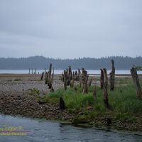
Old pilings across the sand and gravel from Gypsum Creek into Iyoukeen CoveIyoukeen Cove, is a place we have been many times. We have fished halibut here more times than I remember, doing fairly well, a favorite spot. A few years back we landed a 205 pound fish here.
For one reason or another, fate seems to highlight this odd cove every time are in the area. From the first time I noted the unusual name on a chart to the halibut we have routinely caught here. Once when we simply planned to cruise by some odd activity caught my eye, again leading me into this place. Changing course we discovered whales bubble net feeding along the southern cliffs, a sight I will not soon forget.
The odd name is from the Tlingit, Iyukin, and was first recorded in 1869 by G. Davidson, U.S. Coast and Geodetic Survey. This name was accepted and was published in the 1883 edition of the Coast Pilot, to be shown as Iyoukeen on nautical charts ever since.
Google Map of Iyoukeen Cove and Gypsum CreekLocated on the west side of Chatham Strait, the cove is a wide open reach of water, unprotected from the wind and waves that can rage up the strait.
A sand and gravel beach backs much of the cove, with steep hills behind. An odd, very narrow, rocky peninsula separates the cove from Freshwater Bay to the south. Cruise ships, ferries, and fishing boats pass by taking little heed of this seemingly unremarkable cove.
In light of recent events I have been re-reading the history of the early 1930’s Weimar Republic again. The parallels we can see in the current presidential election are simply frightening. A populist leader arising to manifest the resentments and fears of a large segment of our population that feels dis-empowered and threatened. The issues have inspired me to consider again the history of our own country, what it really means to be American.
First page of the US constitutionIt is not so much Donald Trump I am worried about. He is merely a con man who’s game has grown out of all control. No, it is what Trump enables and represents that I am truly worried about. A basic disrespect for the institutions of government put in place by the founding fathers two centuries ago. Trump and his followers do not want to work to improve our government, they want to take a hammer to it and destroy two centuries of success.
Trump has repeatedly indicated his contempt for many of the functions of the federal government. Worrisome proposals by Trump include significantly reducing the freedom of the press, allowing more participation of religious organizations in politics, slashing environmental protections, and repudiating many longstanding international treaties. While the candidate is extreme, a good portion of his political supporters go far further in expressing their desire for slashing at core functions of the federal government.
The AO system was broken, nothing really bad, but something I would need to go up and fix. Reading the nightlogs each morning there are occasionally surprises like this, a sudden re-planning of an otherwise lazy Sunday.
A workshop in the Mauna Kea adze quarry
I suspected that the fix would not take me long at all. But I would be on the mountain… What to do with the rest of the day? I load camera and hiking gear along with my backpack of tools. If I do complete the job quickly I will go hiking. The Mauna Kea adze quarry springs to mind as a likely spot to spend a few hours.
The ancient Hawaiians had no access to metal on these volcanic islands. What they did have was a source of very hard volcanic rock. High on Mauna Kea there were once glaciers, a place where the fury and heat of the volcano met ice. Cooling quickly in the icy realm the lava formed a dense, fine grained rock suitable for making tools.
The rock from this quarry could be shaped and ground into a number of tools, particularly adzes that could be used to cut wood or carve the great ocean going canoes. Tools made from this particular rock were so prized that they have been found in archaeological sites on distant islands across the Pacific.
I have known how extensive the adze quarry is for years. The numbers are abstract, number of find sites mapped, square kilometers of area, just numbers on paper. What I found was quite different than what I was expecting, nothing conveys the actuality of being there.
I was amazed at the sheer size of the piles of flakes. These are sites that were worked for centuries, each workshop accumulating many tons of waste rock flake to tumble down the slope. Having worked with my hands continually over my lifetime, I know how hard hand labor like this is. I stood amazed at the sheer amount of human effort it took to accumulate these piles.
I found I had another misconception to correct… Looking from a distance you see the caves with piles of waste rock spilling down. I had assumed that the caves and ledges are where the actual mining took place, where the basalt was pried from the mountain. Visiting one of the workshops I quickly see this is not the case.
SE Alaska and the coast of British Columbia are a place where the past does not get wiped away. Ruins, wrecks, and abandoned places are often left for nature to reclaim rather than scrapped or redeveloped. When traveling the waterways of the Inside Passage you are often wandering through echoes of the past.
I realize things change, but sometimes the “improvements” seem to involve a loss. A loss of what was, a loss of a little piece of history.
The original early twentieth century interior of Snyder Mercantile, TenakeeThe Snyder Mercantile was a time capsule of another era. Built over a century ago the store was a glimpse into the past. The products on the shelves were fresh, mostly, but the store appeared much as it did decades ago. A single room with a little of everything from bread to fishing tackle and boat parts. They still used the century old cash register to ring up your sale. Never mind the trouble finding tape and ribbons, it still worked, emitting a classic bell ring as the total was calculated.
The rebuilt Snyder Mercantile, TenakeeI was not pleasantly surprised when I made my way into the store. The old mercantile was gone, a modern interior greeted me. Some time since my last visit the past had been swept away. For a minute I could only stand there in the entrance, a feeling of loss overwhelming me. Some time in the last couple years the store has been rebuilt.
Much of the building has been replaced, from pilings to decking new lumber can be seen. The interior pays homage to the original, the walls made from the original tongue and groove woodwork stripped and stained. The stock is groceries, the hardware and tackle is mostly gone, only a few shelves remain. The old cash register is relegated to being a museum piece in the corner, a new computerized machine with a touch screen and laser scanner serves in its place. The satisfing crunch of gears and bell no longer signals each sale.
The rebuilt Snyder Mercantile in TenakeeHaving skipped Tenakee last season I had missed the changes. The renovations were completed last year. To be fair the renovations were probably necessary. The years of Alaskan winters had taken a toll on the structure. This climate is not kind to the works of man, particularly those built of wood. The location, built on pilings over a tidal flat makes this even worse.
Having first shopped in Snyder Mercantile back in 1994 I have been visiting this store for over two decades. Goods brought out from Juneau are not cheap, but we always have something that has run out after a week on the water. Tenakee means a few groceries and a soak in the hot springs. The changes are good, the store is better, but the rebulding of the century old store still seems a loss.
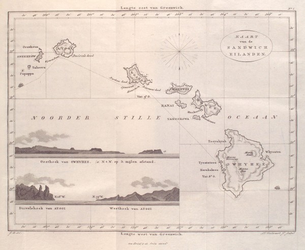
Among the items I found in the NYPL image collection was an 1835 map of the Hawaiian Islands. I included it in the posting on the collection, but the map truly deserves a closer look. It preserves the western view of the islands as of the early 19th century.
The map is reasonably accurate, looking at the coordinates given for key points in the islands shows that they are correctly plotted. The outlines of the islands are mostly familiar. The shapes of Molokai, Maui, and parts of Hawaiʻi do show some odd features that look odd to anyone with a good knowledge of local geography. Any number of points and bays seem exaggerated, note the peninsulas on the north shores of Oahu and Maui. Notably Kealakekua bay is drawn as much more sheltered than it really is, an odd inaccuracy in a maritime map.
Continuing inspection reveals a number of other oddities… There are two islands marked on the map south of Niʻihau, named Tahoora and Papappa. Modern navigation maps mark only one island here, Kaʻula. Tahoora (Kaʻula) was spotted by the Cook expedition and recorded with that name. Reference to Papappa can be found in the 1870 Seaman’s Guide to the Islands of the North Pacific, Part II, W. H. Rosser. Apparently local fisherman reported another island south of Kaʻula. A number of ships looked for such an island in vain. The guide lists its existence as “doubtful”.
Map of the Sandwich Islands (Hawai’i) issued in 1835 by Jacobus Boelen
It is also interesting to note that the coordinate system used is referenced to Greenwich. Thus the longitudes marked at the bottom match those found on modern maps. At the time the prime meridian, the location of zero longitude, was hotly contested between several possible locations. It was not until the 1884 International Meridian Conference that Greenwich became the accepted standard worldwide. This was over the objections of the French who abstained from the vote and continued to use the Paris meridian until 1911.
Of course it is the place names that are the most fascinating feature of the map. Setting aside the Dutch vocabulary and looking just at the transcriptions of the Hawaiian place names one sees familiar names as they were used two centuries ago.
Looking about the map one will note Owhyhee in place of the modern Hawaiʻi, Mowee and Woahoo as the old versions of Maui and Oaho, quite recognizable. If you have read the old accounts you may recognize Atooi as the island of Kauai. We also see Mowna Kaah printed on the map for present day Mauna Kea, similar to the Mauna Kaah found in the Cook expedition journals as the first written version of the mountain’s name.
Map Name
Current Name
Atooi
Kauai
Honoruru
Honolulu
Karakakooa
Kealakekua
Mowna Kaah
Mauna Kea
Mowna Worroray
Hualālai
Mowna Roa
Mauna Loa
Morokinne
Molokini
Morotoi
Molokai
Mowee
Maui
Oneeheow
Niʻihau
Oreehoua
Lehua
Owyhee
Hawai’i
Ranai
Lanai
Tahoora
Kaʻula
Tahoorowa
Kahoʻolawe
Woahoo
Oahu
Currently accepted place names compared to the names found on the 1835 map by Jacobus Boelen
The Hawaiian islands are quite interesting in many respects. Here no single ethnicity has an outright majority. The history behind this makes for fascinating reading. The sugar industry created a need for agricultural labor that was the driving force resulting in the mass importation of several cultures, primarily Chinese, Japanese and Filipino, and to a lesser extent several others. In addition to the original Hawaiian inhabitants and later Americans immigrants the islands became quite culturally mixed.
Upright stones of the navigational heiau north of MahukonaThe largest group now present are those of Asian decent making up 37% of the population. This is while Caucasians make up only 26% of the population and native Hawaiians and Pacific islanders represent 10% in total. The resultant cultural mix is something that many, including myself, enjoy about the islands. Throughout the year you are exposed to cultural ideas, language, the foods and festivals, of half a dozen cultures.
While there are many benefits of several coexisting cultures, there are issues as well. Hawaiʻi is in many ways ahead of much of the world. These cultures have, for the most part, learned to coexist in ways that much of the world is still struggling with. This is not to say that everything is perfect. Controversy has a way of revealing issues that otherwise often avoid exposure, and we have seen a bit of controversy as of late. There are existing issues that have long been present, but are avoided as they are neither simple nor easily resolved. It is no surprise that the issues have stemmed from the clash of cultures that have landed on these islands across the centuries.
It is the first arrivals here, the Hawaiians, that often see themselves as having lost the most with the arrival of so many immigrants from various other nations. The issues surrounding Mauna Kea have given Hawaiian activists a new rallying point and increased visibility that they have taken full advantage of to express their cause.
It is a quiet place today, a favorite anchorage near Juneau for local sportsman and boaters, rimmed with a dozen homes and cabins. Funter Bay is a convenient place to stop and spend the night for anyone coming into or out of Juneau and Auke Bay. No surprise that we found ourselves using this safe anchorage no less than four times over two weeks. As I have come to find, it is more than a convenient harbor, it is also a very interesting place…
At the beginning of the 20th century, Funter Bay was home to a large cannery and mining operations. Photos from 1900 to 1930 show a bay alive with activity, with substantial buildings supporting the mine and cannery, a post office, church and everything else one would expect in a thriving community. The area has quite a history with tales of industry and tragedy. The stories are a vignette of Alaskan history that typifies the lives of those who came to this place generations ago.
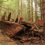
Even with a quick exploration of the area, signs of the past are scattered about to catch an observant eye and inquisitive mind. Pilings on the shoreline, unnatural objects along the beach. Going ashore and poking about soon reveals that the forest conceals even more evidence that this bay looked much different in the past.
Barges used by the Thlinket Packing Co. of Funter Bay decaying in the woods.Just behind the treeline of Coot Cove are four barges, well built working vessels now decaying in the woods. the decks are collapsing and spruce trees grow through the frames. Remains of a skid ramp and heavy cables secured to large tree stumps show how they came to rest here well above the tideline. Two large motors and winch gear are rusting away on the uppermost barge.
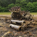
On the northern shore of Coot Cove there is the wreckage of a substantial vessel. At low tide a large engine betrays the wreck. On a previous visit I had motored around the engine with our launch, taking a few photographs of a large four cylinder diesel engine protruding from the water. This year was the first time I had had an opportunity to examine the wreckage more closely, low tide had completely exposed the wreck to examination. I could walk where I had previously floated.
Update 25Feb2015: Received an email from a historian at the Alaska Department of Natural Resources. They believe the wreck is the Anna Helen, a tugboat that burned from a gasoline explosion caused by an engine backfire on October 22, 1928.
Update 1May2015: Found a great website by Gabe Emerson who grew up in Funter Bay. He has done some research on the various wrecks, posting the information to his blog. His guess is the tugboat Morzhovoi, an 84 foot diesel vessel owned at one time by the Thlinket Cannery. He also notes that the Anna Baron sank near Swanson Harbor.
Remains of a tugboat on the shore of Funter Bay, possibly the cannery tender Anna BarronA closer examination of the wreck tells much about the vessel and how she met her end. Charred timbers and piles of metal fittings in the bilge shows she burned to the waterline, most likely ending up on the beach as she burned.
Given the winch gear, the large engine and the size of the vessel it is clear that this was some sort of tugboat, equipped to handle barges similar to those found nearby in the woods. She was also extravagantly equipped with electrical gear, several generators, motors and heavy wiring feature among the wreckage. There are also more mundane items, a metal sink and silverware testify to a comfortable existence for the crew. A radiator shows that she was heated, a nice feature in Alaskan waters.
In an attempt to learn more about the tug I did a little research. It did not take long to find more information on Funter Bay. Historical photos in several online archives featured images of the “Thlinket Packing Co.”, with photos of a large cannery and associated fish-traps. “Thlinket” is obviously an alternate spelling used at the time to refer to the local Tlingit people native to the region. Other photos show a Tlingit village in Funter Bay and note that they also worked in the cannery.
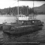
The cannery tender Anna Baron moving barges of fish in Funter Bay, image by Case and Draper, Aug 2, 1907, from the Alaska State Library Historical CollectionThe historical photos came with a surprise… Images of a tugboat working as a cannery tender, moving barges of salmon from the fish-traps to the cannery. The tug, the Anna Barron, looks to be an exact match for the wreckage found on the north shore of Coot Cove. One particular photo shows the vessel with two barge loads of fish, close to where we had anchored for the night, a few hundred yards from the current location of the wreckage.
Based on the photos I tentatively ID the wreck as the Anna Barron. A vessel of the right size, type and in the correct historical context. If this is the Anna Barron, she lies just across the cove from the barges that she spent decades shuttling to and from the fish-traps along Chatham Strait and Admiralty Island. One has to wonder about her story… How did she end up burned and sunk in the bay? An accident? Deliberately burned when she was too worn to be used or sold?
There is a problem in identifying the wreckage as the Anna Barron… The engine mounted to the hull is produced by a company that was started in 1916, yet the Anna Barron is shown in 1907 photographs. It is possible the engine now in the wreck is not her original engine, but was a refit somewhere during her working life. A refit is not out of the question. A 1907 photo identifiers the Anna as a steamer, typical propulsion for a vessel at the turn of the century. It may have been desirable to refit the tug for diesel with the increased power and reduced maintenance costs offered by the then new technology.
No evidence in hand to prove the case. It may be that the vessel wrecked in Coot Cove is simply some other boat. There is a second candidate, the Barron F., a 75ft cannery tender. Information with this vessel also specifies a different engine, and seventy five feet appears to be somewhat longer than the wreck on the beach.
The barges in the woods are almost certainly those seen in the photographs. They are an exact match in size, shape, construction, including the posts on the decks used to contain the cargo of fish. A reasonable guess is that they were pulled up on the shore for protection from the elements through the winter, ready for next year’s salmon season. A season that never came with the closing of the cannery. They lie forgotten and decaying where they were left.
Funter Bay was gradually abandoned, the mines and cannery closed. The area never becoming a thriving settlement like nearby Juneau or Hoonah. With the land in private hands, is was not added to the holdings of the U.S Forest Service or an Indian corporation. The bay is now dotted with private homes and vacation cabins. As one of the best anchorages near Juneau there are usually a dozen or so boats swaying at anchor each night during the summer season. You have to look a little to see the signs of a rich history, but they are there and fun to explore.