The Sealion Cove trail is a beautiful hike over remote Kruzof island north of Sitka, Alaska. The only way to access the trailhead is by boat or seaplane. The trail starts on Kalinin Bay, passes through a small pass between two mountains and then drops down to the Pacific Ocean and the beautiful beach at Sealion Cove. At the midway point, in the pass, is a small and apparently unnamed lake.
The first section of trail along the top of Kalinin BayI have been to the lake and back years past, but the group I was hiking with was not ready to go the full distance to the beach at Sealion Cove. This is not a place to hike alone. We ended up turning around after enjoying the scenery at the lake. This time I really wanted to go all the way.
The first section of the trail follows the shore of the wide estuary that drains into Kalinin bay. The trail follows the treeline where the high tides and saltwater prevent the spruce from encroaching further. While there has been some effort to improve the trail here, with gravel spread and rock strategically placed at the many small streams, the effort looks to be futile. Deep mud pockets sucked at our feet and required careful footing. The dry socks in my pocket were obviously going to stay in my pocket, my river sandals often full of mud.
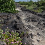
A well made trail across the 1856 lava flow, allowing an easy crossing through the aʻa. Too well made, not something built by the State of Hawaii, this is older, much older. One feature of the old trails was large flat stones laid along the path. I suspect the trail was cut soon after the lava flow cooled, reconnecting the villages along this section of the Kohala coast.
An ancient trail across the lava flows at Kapalaoa
My goal was not to visit the sanctuary itself, I have been here several times. Instead, my plan was to walk the 1871 trail south along the shore, something I had never had a chance to do. I did start at the sanctuary, passing through and shooting a few photos of Kiʻ i before heading south.
The 1871 Trail proceeds south from Puʻuhonua O HōnaunauThis historic trail proceeds south from the visitor center, cutting across the point and then along the shoreline. The trail connected villages and religious centers along the coast. North of the park the trail has become the modern route 160, crossing over the coastal plain to Kealakekua Bay. In satellite shots you can follow the trail along long sections of the Kona Coast. Along the Kohala Coast the King’s Trail was built in a similar fashion and serves the same purpose.
The trail is what was called a two-horse trail, wide enough for two horses to pass with room to spare, about eight feet wide. A curb of stone runs along both sides, while the roadbed between is cleared of rock and sometimes filled with sand or gravel to level the worst pits. In places the trial is built up to cross low areas with substantial stonework. The result reminded me in many ways of Roman roads in Europe, built to a similar pattern and cutting straight across the landscape.
On both side of the trail there are numerous remains of the ancient settlements. Stone walls and raised platforms reveal what was once a thriving settlement along the shoreline. There is the foundation of John Ahu’s house, complete with a cistern and an old grave. The remains of the ʻŌmaʻo Heiau, a hōlua slide and more are alongside the trail as you proceed. Ask at the visitor center desk for a guide to the various points of interest along the trail.
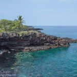
A cove of blue water beneath the sea cliffs of Kiʻilae BayAbout a quarter mile south of the visitor center the trail reaches the shoreline and runs along the top of the sea cliffs. The view is stunningly beautiful… small coves of crystal blue water lie at the bottom of the rugged cliffs. The coral reef is clearly visible, even from fifty feet above you can make out fish feeding amongst the coral heads. Here and there the bright yellow of small schools of tangs add color to the blues and greens. Next time here I need to remember to bring some snorkeling gear.
About halfway the trail is built against a small sea cliff. A large stone ramp was constructed to allow travelers to ascend the cliff. The amount of stonework serves to highlight how much work went into building this coastal access trail.
The south boundary of the park is a mere 0.8 mile along the trail, an easy stroll. Perhaps add a couple points of difficulty for the rough, rocky nature of the trail. It takes about half an hour to reach the abandoned fishing village. From there the trail continues south, out of the park. It becomes substantially overgrown, the path reduced to a cut through the brush with the occasional branch to push aside. I proceeded a bit further, but became rather annoyed with the amount of spider web I was accumulating.
As I sit amongst the abandoned stone walls of Kiʻilae Village it is interesting to imagine what the scene would have looked like a well over century ago in the 1870’s. A thriving settlement with travelers coming and going along the trail. Fishermen carrying their catch home, village women doing the chores and shopping, the tasks of life that never really change. Perhaps a royal procession going north to the temples at Puʻuhonua O Hōnaunau. The period was an interesting one, when western ways were mixing with the ancient patterns of life in the islands.
If you have some time while visiting Puʻuhonua O Hōnaunau, take an hour and walk the old trail. The scenery alone makes it worthwhile, with a bit of history thrown in.
There are few open paths to trail ride on this island, a place where landowners gate every side road and jealously guard any access. There are a number of exceptions, but you have to look to find them. One such is a power line road off of Saddle Road. The power line is gone now, the stumps of poles remain where they were sawn down years ago. The road runs arrow straight across the landscape, now serving forestry crews, pig hunters and hikers. Enough traffic traverses the path the keep it clear of growth. Here is a glimpse of natural Hawai’i, where invasive species are relatively few and the calls of native birds echo amongst the ‘Ōhi’a.
Getting ready to set down the trail to Emesine CaveWhile I had hiked the trail a couple years past, cycling gave me a whole new appreciation for the ruggedness of this old power line road. Whole sections were cobble that shifted and rolled under the knobby tires. I got a lot of rock dodging practice, carefully choosing where to run my tires through the rough lava. In the end I was forced to walk the bike along whole lengths of the route where the loose cobble was simply too dangerous to ride. The sections among more recent flows were the rough parts where the road was simply bulldozed through the rock.