If I were to use one word to decribe a recent visit to the park it would be…
Crunchy.
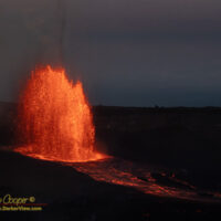
The year and a half long series of eruptive episodes has been beautiful and exciting. Tall lava fountains every couple weeks that put the lava in Hawaiʻi Volcanoes National Park, drawing huge crowds and providing a spectacle for both tourists and us island dwellers alike.
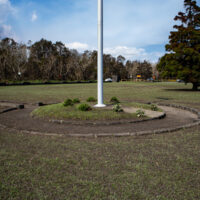
A combination of several high lava fountains and our usual winter Kona storms has resulted in episodes of tephra falling across the main sections of the park, closing both the park and the Mamalahoa highway.
The southerly winds brought about by Kona low pressure systems has sent the tephra northeast instead of the usual southwest. Instead of settling in the desolate and uninhabited Kaʻu Desert, tephra has instead fallen heavily across the park entrance area and highway, the visitor center, and the main caldera viewpoints. Tephra has reached beyond the part to impact Volcano Village, and even reached as far as Hilo.
Continue reading “Crunchy”