Back in January I missed the eruptive cycle, spending several days in the park doing some trails I had always meant to hike. No lava needed to have a good day in the park, I went for a hike.
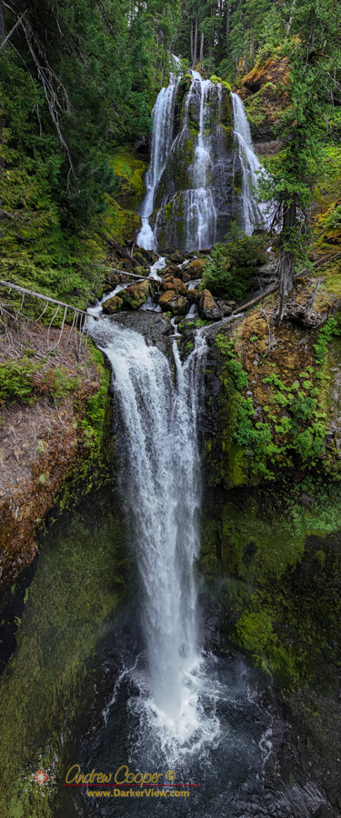
So… I assembled something from all of the video I took at Falls Creek Falls and Panther Falls. A small taste of a waterfall hike in the forests of Southern Washington.
Two goals… Get out and enjoy a proper PNW forest hike. Yes, we have waterfalls in Hawaii, just not quite the same. Second… Take a pile of photos and video. I do enjoy a day set aside for photography.
The drone made a huge difference. Falls Creek Falls is particular is quite large and impossible to properly capture from the ground. The drone made all the difference, able to sweep along the waterfall from the air or fly right up to unreachable locations and shoot at lovely angles.
For the most part I was just spending time with the folks, a week hanging out and even doing some chores around the house.
I did have one day planned in an otherwise unplanned week… A hike somewhere, a chance to enjoy a bit of summer in a classic Pacific Northwest sort of way. This year it would be waterfalls.
I had two waterfalls picked out… Falls Creek Falls and Panther Falls, both located in the hills above Carson, on the Washington side of the Columbia River Gorge.
Along with the waterfalls I had one other stop planned, a quick excursion to the new Mitchell Point Tunnel. Add a lunch somewhere along the way and I had a full day.
An important part of the plan was an early start. I left the house at 4am for a dark drive up the gorge for a planned dawn arrival at the trailhead.
The morning dawned clear and beautiful… It should be a great day.
When standing atop Puʻuwaʻawaʻa the scenery is breathtaking. Five massive vocanoes dominate the skyline… Haleakalā, Kohala, Mauna Kea, Mauna Loa, and the looming Hualālai immediately to the south. It is easy to overlook the smaller, overshadowed features of the landscape. Sitting for a while resting, rehydrating, and enjoying the view atop the grassy puʻu one begins to notice more details in the landscape.
An ʻōhiʻa lehua bloom in the forest above Puʻuwaʻawaʻa
A couple miles southeast of Puʻuwaʻawaʻa are a line of more modest volcanic features, dwarfed by the enourmous mauna but still significant, monuments of rock that tower over the surrounding ʻōhiʻa forest. These old vents are clearly arranged along a rift of some sort in a neat line trending north to south with the southern end pointing directly at the peak of Hualālai.
On the west end of the park is a vast area I had never ventured into, the Kaʻū Desert. This was going to change, the two hikes on the top of the list for this particular stay in the park were Mauna Ulu and the Kaʻū Desert. Having accomplished the prior it was time for the latter.
The Kaʻu Desert along the Mauna Iki Trail
There are two sets of trailheads to enter the Kaʻu Desert. Several of the trailheads are along Highway 11 on the north side of the area. To avoid leaving my car on the side of the main island belt road I chose to use one of the trailheads along the Hilina Pali Road inside the park. Here one can find the Maunaʻiki Trail leading to Twin Craters.
Mauna Ulu first erupted in May 1969 and would continue for the next five years. In the course of those eruptions lava would occasionally fountain over 1,700ft high while flooding much of the surrounding area, eventually constructing a lava shield nearly 400ft above the original ground level.
Mauna Ulu as seen from the top of Puʻu Huluhulu
In many ways the Mauna Ulu eruption was very similar to the Pu‘u ‘Ō‘ō eruptions that would start a decade later and continue for well over three decades. It is the Pu‘u ‘Ō‘ō eruptions that formed my first memories of Kilauea with television news of homes burning in the Royal Gardens subdivision and visits to the ocean entries at Kalapana. While Pu‘u ‘Ō‘ō remains somewhat remote, Mauna Ulu is far more accessible.
Around this island the observant hiker will become attuned to various clues that give a view into the natural history or human history of the landscape.
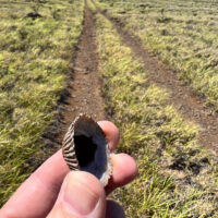
An ʻopihi shell found along a utility line access road far from the ocean
One such clue is the presence of seashells, these are usually a giveaway of ancient Hawaiian occupation of a site or locality. The bleached and broken bits of shell a long lasting remant of meals harvested from the shoreline and brought to places well inland. Often found around lava tubes or water sources these shells let you know that others have passed here before.
An ʻopihi shell along a power line access road near Waikoloa? This is a bit unexpected. I have to stop and pick up this shell, pausing my trek to puzzle out this anomaly.
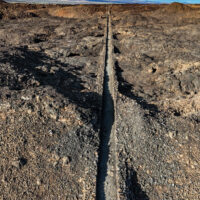
The region south of Waikoloa along the shore seems to be a barren field of lava with little to offer beyond miles of dark rock and baking sun. That may seem to be the case, but there are surprising gems out in those lava fields.
Looking along the King’s Trail south of Waikoloa
The plan? As usual hike the King’s Trail south from Waikoloa, but this time explore some of the smaller trails I had passed by in the past. Perusing the satellite imagery reveals a surprising number of trails through the lava. Considering the substantial effort it takes to cut a trail through the worst aʻa lava those trails must be significant somehow.