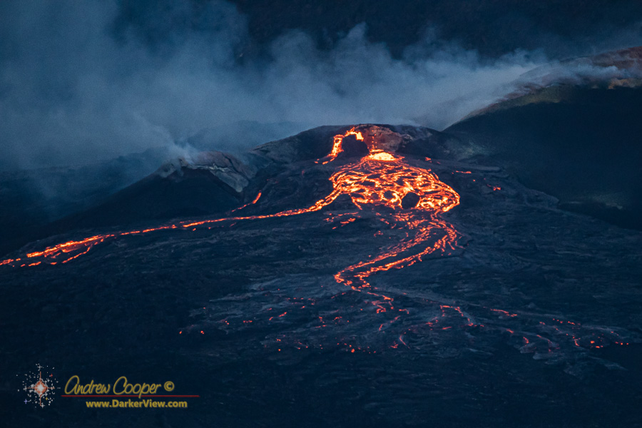
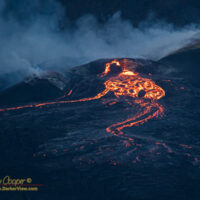
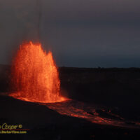
End of the Road

A number of roads I once drove have been claimed by volcanoes over the years.

Crater Rim Drive literally collapsed into Kilauea Caldera, the road, viewpoints, trailheads… All gone. Highway 132, Pohoiki road, Kopoho Road, all buried during the 2018 eruption. Sections of Highway 130 near Kalapana, slowly covered by the Puʻu Oʻo eruptions flowing to the sea.

And the Mauna Loa access road, cut by the 2022 Mauna Loa eruption.

How many times did I travel this road? Quite a few… Trips up to set up my own telescope near the NOAA research station. Contracting work at the NOAA station in the wake of the pandemic. A couple trips up just to enjoy the scenery or do a little photography.

Then an eruption, the first eruption of Mauna Loa in near four decades. The lava flows cut the road in two places.

I had not been up to where the lava crossed the road since the eruption. That was until until this last weekend. I finally got up there… No reason, just enjoying the mauna on a pretty Sunday morning. I parked down below and rode the bike the last few miles up to the lava flow.

As expected the road just vanishes under the lava. An impressive pile of aʻa clinkers covers the road twenty feet deep. Three years later I am rather surprised the road has not been re-cut into the observatory.

Here it is, lava across the road, power lines dangling, as far as you can go unless you are willing to abuse yourself crossing 300 yards of jagged aʻa. I sent the drone for a look.

The 2022 lava flow crosses the Mauna Loa access road at 8,800ft

The Start

I somehow always miss the very start of the eruption.

A massive lava fountain during episode 23 on May 25, 2025

For episode 9 I was just a couple miles away in another part of the park when the eruption broke out.

For episode 15 I had been on the rim for hours waiting for the expected start when I finally gave up and went to grab breakfast. The eruption started while I was waiting for my omlette at the Crater Rim Cafe.

This time I saw it.

Continue reading “The Start”

Episode 15

Reading the tiltmeter data it was clear that the pressure was building again, an eruption appearing likely in the next day or two. The last episodes have produced ever higher lava fountains, I expect episode 15 to go even higher and I truly wish to see it when it happens.

Right on schedule the first lava appeared, a little rivulet of lava overflowing the north vent onto the crater floor. If the pattern repeated this would be followed by high lava fountains in the next ten hours or so. Episode 15 was on.

Strong glow from the eruption vents illuminate the heavy volcanic plume above between surges

Tomorrow it would be, and as tomorrow was also a holiday for me, Prince Kūhiō Day, I would be free to make another volcano run!!

We are a go.

The same plan… a 2am alarm, hit the road, 4am in the park, hike to the Keanakāko’i viewpoint.

Continue reading “Episode 15”

Geology of Waikoloa

While writing up my visit to Goat House Tube I was again wondering how old the lava tube was, it is clearly old, but how old?

A Google Earth image of Waikoloa overlayed with a geologic unit map
A Google Earth image of Waikoloa overlayed with a geologic unit map showing the various lava flows from Mauna Kea and Mauna Loa, pinks are Mauna Kea flows while Mauna Loa flows are green

Most of the Mauna Kea lava flows upon which Waikoloa sits are ten to twenty thousand years old, but the Mauna Loa flows that start just south of the village can be quite a bit younger.

Just a few miles south of the village one can find the 1859 Mauna Loa flow, the longest lava flow in the state representing a very long eruption that produced an enormous volume of lava. This is the flow that reshaped Kiholo bay, destroying the large fishponds that could once be found there.

Continue reading “Geology of Waikoloa”

Mauna Ulu

Mauna Ulu first erupted in May 1969 and would continue for the next five years. In the course of those eruptions lava would occasionally fountain over 1,700ft high while flooding much of the surrounding area, eventually constructing a lava shield nearly 400ft above the original ground level.

Mauna Ulu as seen from the top of Puʻu Huluhulu

In many ways the Mauna Ulu eruption was very similar to the Pu‘u ‘Ō‘ō eruptions that would start a decade later and continue for well over three decades. It is the Pu‘u ‘Ō‘ō eruptions that formed my first memories of Kilauea with television news of homes burning in the Royal Gardens subdivision and visits to the ocean entries at Kalapana. While Pu‘u ‘Ō‘ō remains somewhat remote, Mauna Ulu is far more accessible.

Continue reading “Mauna Ulu”