When will this eruption end? The answer to that is a question many are asking on this island. Today we might just be seeing the answer.

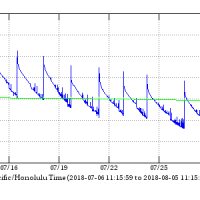
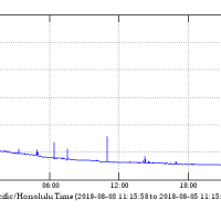
Even more interesting is the deformation data from the summit.
A month ago I had an idea, one born of watching other similar processes… The interval between summit collapse events should begin to increase as the caldera collapse ends. This may be the first clear sign that this eruption is beginning to end or at least shift to a less active phase.
I posted the idea to the Facebook group Hawaii Tracker, where the idea seemed to gain some agreement from the gathered eruption enthusiasts that frequent the group.

This morning we are now well over that interval. for the first time since the summit collapse began the graphs have flattened out!
At the same time the earthquake activity at the summit has dramatically declined. Residents around Volcano, now accustomed to nearly constant earthquakes, report an eerie sense of calm in this morning.
My personal opinion? I suspect the summit magma chamber has given all it can give, that the collapse is bottoming out. Does this mean the eruption is ending? A very qualified maybe. The eruption could end, or it could continue as a much reduced rate of flow, something more like the rate we saw from Puʻu Oʻo for decades.
Just my read and best guess of the situation. We will just have to wait and see.


Isn’t this the beginning of a new cone or volcanic peak on the eastern side of the island as the volcanic plume migrates eastward (or the islands migrate westward)?
No, just another flank eruption. Check out the maps, the lower east rift zone through Puna is littered with cones just like the one around Fissure 8, some much larger like Kapoho Crater. For a nice summary of this and other nearby historical eruptions you can read this… https://volcanoes.usgs.gov/vsc/file_mngr/file-185/USGS%20Preliminary%20Analysis_LERZ_7-15-18_v1.1.pdf
Good prediction Andrew. I hope it lasts.