The weather can be glorious, grey and cold, or simply miserable. I have experienced trips with nothing but sunny days and temperatures allowing shorts and sandals. Other times have brought rains that equaled anything I have seen, when it seemed the sea was both above and below. Sailing through narrow, rocky passages with nothing but radar to see the shore a few hundred feet away, shrouded in fog.
You take what you get on a trip, no way to reschedule now. Rain or shine, fog or mist, each can be beautiful in their own way to an traveler willing to enjoy the experience, whatever life brings.
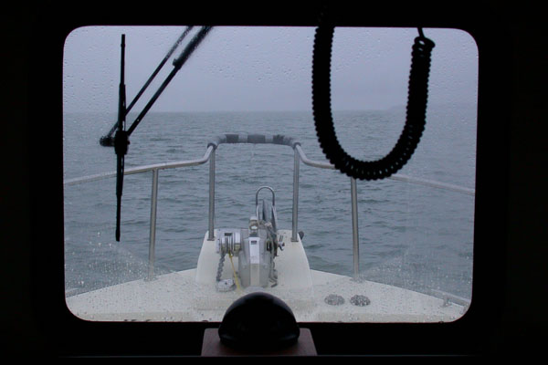
A grey view out the wheelhouse window of the Chrisara on Chatham Straight, 3 July 2004
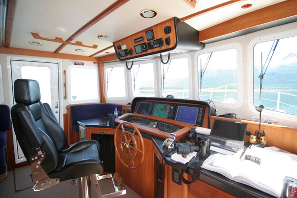
The bridge of the Nordic Star, home for the next three weeks. I will be spending many hours at the wheel as we explore. There are two marine radios above along with a stereo system with CD player. (Note to self, put together a few CD’s of my playlists). On the dash are three flat panel displays that can be configured to display the GPS, marine charts, radar and depth finder display. The view is the best in the boat, aside from climbing to the upper deck. Also visible is the usual clutter of charts, binoculars, camera gear, radios, drinks and munchies.
The spacious bridge of the Nordic Star, a 52′ Nordic Tug
Nordic Tugs is a company based in Burlington, Washington on the Puget Sound. They make a line of boats intended for cruising the coastal waters of Washington, British Columbia and Alaska. Comfortable, roomy, well appointed and very seaworthy. One of these boats will be our home for the next few weeks as we explore the inland passages of southeast Alaska. An ideal way to experience the spectacular scenery of the region.
Nordic Tugs Charters of Juneau operates and rents a fleet of tugs. It is these vessels we have used in our family expeditions each year. From the smaller 32′, to the larger 42′ Chrisara and the largest 54′ Nordic Star. It is this larger vessel we will be renting again this year. Three staterooms, plenty of freezer space, a full galley, and a large bridge that does not seem crowded even when the entire crew comes topside to view a whale.
I expect to get a fair amount of handling practice with the boat this year as I will be staying the entire three weeks to assist my father with boat handling, a combination first mate and deckhand.
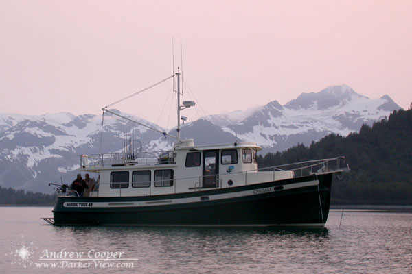
The 42′ Nordic Tug, Chrisara, anchored in Blue Mouse Cove, Glacier Bay, Alaska, 28 June 2004
July is here and my long awaited Alaska trip is at hand. For a three weeks I will be exploring the waterways of SE Alaska aboard a 52′ motorboat. Crewing for my father as we enjoy a family escape from the world. I hope you have been enjoying the post so far.
One aspect of this trip is the nearly complete severing of net access after we leave harbor. No internet, no e-mail, no cell phone, no blogging for nearly the better part of a month!
This will be tough.
I will have a netbook along, with the ability to at least compose postings and process my photos. There may be a couple opportunities to get e-mail and post, but they will be fleeting and I have no idea just how much I may get done in the few days we will be in port to resupply and pick up other family members and guests.
I have scheduled a series of postings to give my readers something while I am out of contact. Mostly photos, Wordless Wednesdays and similar stuff, nothing with any immediacy. If a world-shaking event does happen to occur, it may be days before I find out. Most of the posts are photos and observations from past trips to Southeast Alaska, so between the scheduled posts, and all of the inevitable new stuff when I get back online, Darker View is going to be a bit of an Alaska blog for the next month.
I will also be highly restricting commenting for the three weeks as I will not be able to stop by and moderate. No sense in giving the spammers a free ride. If you need to comment or contact me your best bet is to drop an e-mail. Those at least will be sitting in a que for me to deal with.
When I am again connected to the world I expect to have hundreds of photographs and many stories to tell. Look for a flood of postings and additions to the gallery!
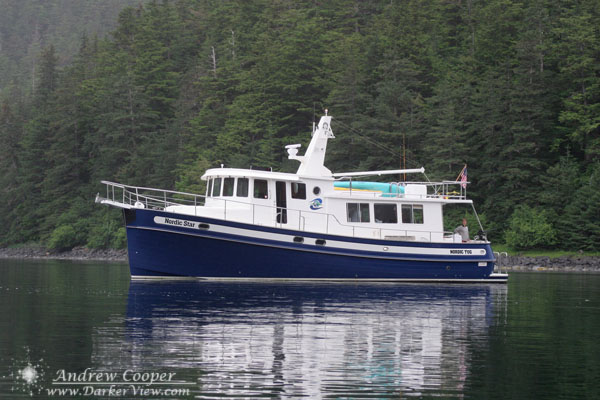
The 52′ Nordic Star built by Nordic Tugs of Bellingham anchored in Kalinin Bay on our 2006 trip
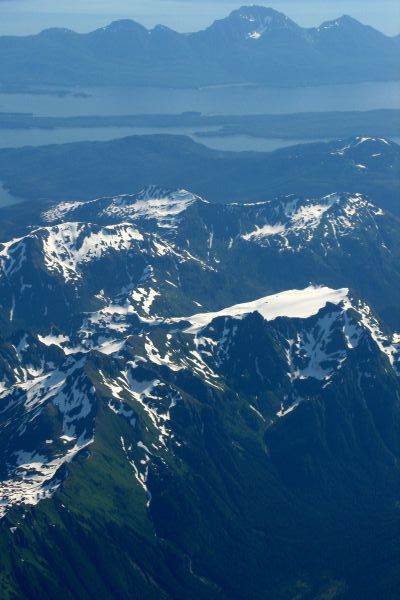
The view from the aircraft window as typical Southeastern Alaskan scenery slides by, the interior of Admiralty Island with the Glass Peninsula in the backgroundThe topography of Southeast Alaska is beautiful beyond words. Tremendous mountains carved by glaciers. These left huge valleys flooded when the glaciers retreated and the sea levels rose at the end of the ice age. The result is a boater’s paradise, endless passages, bays and coves to explore, with mountains towering overhead. What roads exist usually end a few miles from town and the only real way to get about is by air or by boat.
A land where man does not quite rule, cities and towns are far apart and wilderness surrounds. Travel very far in any direction and you soon leave civilization behind.
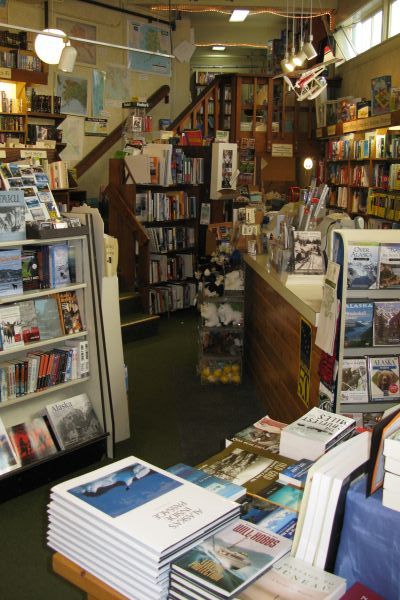
The interior of Hearthside Books on Front Street, JuneauLeaving the women behind I stride towards the one shop I want to look through. My wife, my mother and her best friend– their idea of shopping and mine do not mesh. We know this and have arranged a plan, I leave them for an hour, to meet again at the vehicle.
I rapidly pass storefront after storefront, fine jewelry and tourist kitsch have no attraction for me. A few pretty pieces in the galleries draw a glance or two, but I turn and walk on. Memory leads me down the street and away from the docks, towards a shop I have visited in years past and I only hope it is still there.
Leaving the waterfront district and the tourist shops behind, I climb another block, to a shop occupying an oddly shaped storefront where the street splits. The result is a pie wedge shaped building, the shop I want is in the point.
This is a place I will always enjoy, a store filled floor to ceiling in books. It is a small shop, no literary supermarket, there simply isn’t the space. But the book-buyer here carefully chooses the selections, there seems to be anything you could want in the one foot of shelf space devoted to each subject.
A single rack, three feet of wall, is Sci-Fi and Fantasy. I have either read most of what is available, or know the authors displayed are not ones I enjoy. I make a couple selections, a classic Heinlein I have not read since I was a young teenager and one by Ben Bova I do not know. These I will save for traveling, to pass the time during the trip home with a long layover in Seattle.
For the next selection I rely on the advice of the sales clerk, a field guide to Alaskan birds. Every vacation is marked by what you forget at home, for this trip one of the forgotten items was a well worn copy of Sibley’s Western Birds.
Purchases made, the clerk ushers me out the door, closing time had passed while we chatted and exchanged credit card slips. I have few minutes before I must meet the gals, so I stroll back towards the docks and back into the crowds from the cruise ships.
With the first cold weather of the year I planned a trip to Sentinel, one of our favorite winter observing sites. The site features dark skies and good company. The forecast was for clear skies, so Saturday afternoon I packed up my big dob and headed down the freeway.
Steve Dillinger’s 20″ Dob awaiting full dark at Sentinel, AZ with Venus and the Moon shining behindThe sky started a little rough, with high cirrus and contrails scarring the blue lit by the the glow of sunset. The thin crescent Moon and Venus were gorgeous among the bright gold wisps. Shortly after dark these annoyances quickly cleared leaving a clean sky. Seeing was soft all night, transparency was decent, but poor at low altitude as views into Fornax or lower demonstrated.
The author’s setup awaiting a dark December sky with Deep VioletI counted over 20 vehicles a little before sunset, but a least 10 more rolled in at sunset or just after. After a few hours there was a steady rate of departure as the cold night took its toll on Arizona observers.
I spent the first half of the night touring old friends and a couple new objects, but was basically killing time waiting for H400 objects to rise. After midnight the objects I had been waiting for had risen high enough to appreciate properly and I started to work, cleaning out Pyx, Lyn and Pup of a few remaining H400 objects as well as chewing on western UMa a little. It looks like I have 28 objects left, almost all in UMa, the end is in sight!
Around 0300 the breeze had become a steady cold biting wind and I finally packed it up and pulled out. I had already had around nine hours of good observing so I can call it a success. I wasn’t the last, there were at least two observers still going when I pulled out.
The telescope line at Sentinel for the 2005 Sentinel-Schwaar Star Gaze
A Messier Marathon, one of the crazier ways we celebrate our love of the night sky. Try to find all 110 objects on Charles Messier’s catalog in a single night. It is possible, barely, to do this. It is a challenge of skill and perseverance, and a lot of fun. In 2005 I joined a group of friends at Arizona City at the 2005 All Arizona Messier Marathon. This site has hosted the most successful marathons anywhere, a great site and a large group of very skilled observers makes the competition tough.
The author waiting for darkMy immediate competition was my young friend Carter Smith. Carter and I marathoned together, often racing on objects and comparing scores through the night. I had meant to quietly work on H400 galaxies in Virgo, but Carter sucked me into marathoning with him. Great night with good transparency and for once this winter and spring, NO clouds. Seeing was great at sunset with wonderful views of Saturn while we waited for full dark. The seeing deteriorated badly after dark with cool and warm breezes warring over the site. But transparency is what you want for a perfect marathon which is what we got.
Briefing the attendees on the rules of our messier marathonI managed to stay ahead of Carter most of the night using my 18″ while he was using a 10″. Actually parts of the marathon are much harder with a big scope, particularly the Virgo cluster where a big scope sees all of the dimmer galaxies and not just the M’s you want. I used the setting circles only to confirm objects a few times, so both of us ran this one manually. We ran on purist rules, Telrad and charts the only tools allowed to find the object! The All Arizona Messier Marathon allows setting circles and GOTO scopes, but we are free to make our own rules a little tougher.
Late in the night Carter found my weakness, the 18″ will not depress below 5 degrees elevation, so he could get objects coming over the horizon before I did, after that he was ahead most of the time. Except a few occasions when guile won out against youthful enthusiasm and young, sharp eyesight. In the end we both scored a 109, the best that was possible with M30 being impossible. We had to work on M74, M73 and M72 together to be sure, but the spottings were confirmed by both of us. All in all a great marathon!!!
The observing field at the Farnsworth Ranch, with the Silverbell Mountains in the background and Kitt Peak just visible at far right. The field is unusually green after heavy spring rains. The clouds are rapidly departing to the east.
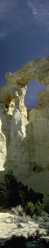
A look at a map of Southern Utah will show that the state is littered with natural bridges and arches. There are hundreds, each different, many picturesque, and dozens more so small they are not shown on the maps. What makes Grosvenor Arch different? maybe the effort of getting there, and the truly beautiful landscape on the way.
The road to the arch is a short-cut from Page, Arizona to Bryce Canyon NP in Utah. The choice is 150 miles around via Kanab, or 50 miles through the wilderness, 40 miles of which is on dirt road. But what a road, through the heart of wild sandstone country, passing Grosvenor Arch, Kodachrome Basin State Park and thousands of acres of countryside that would be a state park anywhere else in the country, except that here in Southern Utah this is considered ordinary.
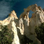
Grosvenor Arch in southern UtahThe arch itself is a tall structure of sandstone arching over 60 feet of open air. In the photos you can see that is actually a double arch with a small secondary opening to the left of the main arch. Unlike the graceful arches of Arches National Park or the Navajo Reservation this arch is blocky and hardly smooth.
It is possible to climb to the top of the arch if you go around to the east. Here there is a steep slope leading to the top of the small ridge behind the arch. The slope is littered with crystals of selenite weathered from the soft rock. When you reach the top you are presented with a view through the arch from above. DO NOT climb out onto the arch however, unless you really don’t want to explore the rest of this marvelous region.
Forty miles of dirt road is not to be traveled lightly, check with the Kane Co. sheriff department or with local residents at Big Water or Cannonsville about road conditions. The first ten miles of the south end of the road is made from bentonite clay. For those unfamiliar with this wonderful/horrible material let me say this. When mixed with water there is nothing slimier or stickier than bentonite. It will instantly coat the thickest tire tread with several inches of slick mud, reducing traction to nil. I have driven this road when wet, with a four wheel drive, and it was.. interesting. If there has been any measurable rainfall avoid the road for a while. This is not to scare you off, when dry the road is normally passable for a standard passenger vehicle without trouble. When in the backcountry ALWAYS CARRY EXTRA WATER and some other minimal survival equipment is a good idea.
The times I have driven this road I have entered from the south off of State Highway 89, going north. The road wanders for a while across the prairie before entering the canyon that you will follow all of the way to the arch. The geology here is alternately bentonite clay, mudstones and sandstones. There are even some small slot canyons for those who look for them. The turnoff for the arch is signed with the typical BLM wooden signs and is a mile or so off the main road. Continuing on north from the arch you will climb out of the valley and will be treated to views across miles some of the best of Utah’s sandstone countryside. A few miles more brings you to the turn for Kodachrome Basin State Park. Do make this turn for the wild and often comical sandstone scenery. The State Park has an excellent campground with showers. The stone pillars the park is known for are everywhere, there is one that stands over the campground looking exactly like a thirty foot tall piece of male anatomy.
The arch itself stands above a small dirt loop at the end of the side road. There are even a few facilities put in by the BLM at the arch, a single picnic table under a steel roof and an outhouse. Nothing fancy, but few who venture this far off the main roads expect a four star hotel.
When you reach the arch take a while and smell the Juniper, listen to the pinyon jays, just enjoy a remote corner of this beautiful region.
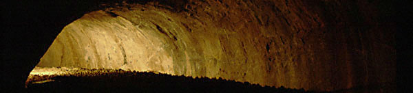
Hidden in the forests near Flagstaff is a bit of a surprise. As you walk among the pine trees you suddenly come to a hole in the ground, a low stone wall your only clue that something is there. For the scattered pines and wide meadows that surround you give no hint of what lies below. But here fire once ruled and lava flowed across the landscape that is so peaceful now. One such lava flow has left a unique feature, a lava tube. Here is where the lava continued to flow inside a lava flow that was cooling from the outside in. Here, insulated inside the body of the flow the lava remained liquid and flowed further down the slope to emerge at the forward end of the lava flow. But when the eruptions came to an end and less and less lava was emerging from the volcano the tube started to empty. Eventually the eruptions stopped altogether and what lava remained in the passage cooled where it sat. This left a roughly circular passage half filled with solid lava. Now, millennia later, this passage remains. The fire of the earth is gone, and we can explore.
Lava River Cave (also called Government Cave) is located on National Forest land and is open to the public with no pre-arrangement except your ability to get there and into the rugged entrance. The entrance is a collapsed section of the roof of the lava tube, here you have to scramble down into the earth. Don’t despair as you enter the cave, it get easier after a hundred yards or so of boulders.
It is my opinion, backed up by a few observations, that most of the collapsed rock about you fell during the eruptions or shortly thereafter while the tube was still young. Looking at the sheer size of the collapsed boulders does give one pause. What if a few more fell while we were here? How dangerous is this place? Probably not very, The entrance probably collapsed during the eruptions or shortly thereafter. The huge number of rocks you must cross near the entrance is dramatically different than the clear floor through much of the passage.
After a few hundred feet of loose boulders the floor changes. Here the lava sits where it cooled, forming a level but very rough surface. Looking much like asphalt that the paving crew neglected to run a roller over to smooth out. This is the surface you will be walking on most of the way
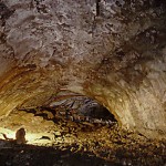
A large chamber within Lava River Cave
Cave Interior
About half way along you face a decision, the passage divides left and right. The way you take doesn’t really matter, the passages join up again a little further on. But the passage to the right is more appropriate to dwarves. There is little sign when you look at the two openings, but the right passage ceiling lowers to about three feet from the floor. Not easy to pass, as the very rough floor keeps you from crawling on hands and knees.
Then look about at the cave today, the ceiling is smooth where rock must have fallen free, but there is no rubble below where it fell. A puzzle! But what if the lava was still molten and flowing, and carried away the debris? If you look around there are still plates of smooth rock embedded in the top of the flow. You can actually see where these plates fell and the still soft lava began to ooze around it as it sank into the soft surface.
Another feature is what I have called gutters (I’m sure vulcanologists have another term). It looks like the lava in the tube formed a crust along the edges, but then as the level of lava in the tube fell it left behind this crust looking like a gutter along the wall of the cave.
It is important to remember that everything here was created by fire. If you remember that lava flowed through this channel and eventually cooled and slowed. it explains what you see around you. Imagine this channel of lava still flowing, but freshly formed, still unstable, plates of rock falling from the ceiling into the lava below. Keep in mind these conditions when you look at any feature of the cave and a little logic will explain what you see.
Eventually you come to the upper end of the cave, where the ceiling takes a sudden dive into the floor, beyond here the tube is completely filled with rock and we can go no further. There may be more to the tube further uphill but it is beyond our reach and we must turn around and return the way we came to once again reach the bright Arizona sunlight.
When You Go..
Lava River Cave presents no major difficulty and is suitable for anyone who wishes a different sort of adventure. You don’t have to be a spelunker to venture into this cave.
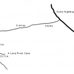
Finding the way to Lava River CaveYou will need a few things however.. At least two sources of light for each person, a bright flashlight and a backup. A gas lantern is a great way to light up the large chambers of the cave and will allow you to appreciate what you see.
Another requirement for this cave is rugged boots and clothing, the floor is quite rough. Hiking boots recommended or maybe an old pair of sneakers that you don’t mind getting ripped up. Even your boots will show a new gouge or two after this hike.
The one remaining difficulty is in finding the place, the turnoff from the highway is not signed, probably a good idea since this is not a good place to show to all of the day tourists headed to the Grand Canyon from Flagstaff. Once off the highway the roads are dirt and passable in any vehicle. When it rains however the road can get quite muddy and it would probably be best to avoid without a high ground clearance or four wheel drive vehicle.
You will need the map. Use your odometer to find Forest Service road #245. After leaving the state highway there is a three mile drive through pine woods and meadows to a T intersection. Turn left and proceed another mile to another left turn for the cave. As of June 1998 there is no sign for the cave at the highway but the next two turns are signed. There are several other roads, look for the small sign or post just inside the turn with some numbers. When you arrive at the cave there is a fence and post barrier that stops you a few hundred feet from the cave just find a place to park and walk the last bit.


 Hidden in the forests near Flagstaff is a bit of a surprise. As you walk among the pine trees you suddenly come to a hole in the ground, a low stone wall your only clue that something is there. For the scattered pines and wide meadows that surround you give no hint of what lies below. But here fire once ruled and lava flowed across the landscape that is so peaceful now. One such lava flow has left a unique feature, a lava tube. Here is where the lava continued to flow inside a lava flow that was cooling from the outside in. Here, insulated inside the body of the flow the lava remained liquid and flowed further down the slope to emerge at the forward end of the lava flow. But when the eruptions came to an end and less and less lava was emerging from the volcano the tube started to empty. Eventually the eruptions stopped altogether and what lava remained in the passage cooled where it sat. This left a roughly circular passage half filled with solid lava. Now, millennia later, this passage remains. The fire of the earth is gone, and we can explore.