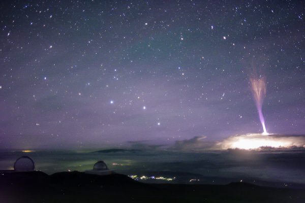
Having an array of cameras on the summit of Mauna kea that capture images all night long has advantages. While the cameras are intended to allow the telescope operators to monitor the weather, they do catch other atmospheric phenomena.
In this case is it a powerful blue jet, a form of upper atmospheric lightning. While these sort of events had been reported for decades, mostly by aircraft pilots, they were only acknowledged by meteorologists after they were first photographed in 1989.
My friend Steve Cullen first noticed the jet in an image from one of the Gemini North CloudCams. It jets upwards from a strong thunderstorm cell passing north of the island, part of the remains of Hurricane Fernanda.
Unfortunately our Keck CloudCam is pointed just a little too west to have captured this event. The next night our camera captures several red sprites, but they are rather distant.
The various cameras capture sprites and jets with a fair regularity anytime there are strong thunderstorms around the islands. If a hurricane is anywhere in the vicinity it pays to check the archives. This jet is bar far the most impressive yet.
Enjoy the image…

Update: On Facebook we were having a discussion about how tall the jet was. I calculated the image scale of the camera, a Canon XTi with a 20mm lens, arriving at about 59 arcseconds per pixel. I also measured the jet as 840 pixels high (there is some extension of the upper part in a hard stretch of the image). Thus the jet is 13.74 degrees high, now all you need is distance to the cell.
Tom Polakis found a good satellite image from the night in question showing the storm about 210 miles away from the summit of Mauna Kea. This and a little trigonometry shows the jet rose about 51 miles above the top of the storm clouds!
