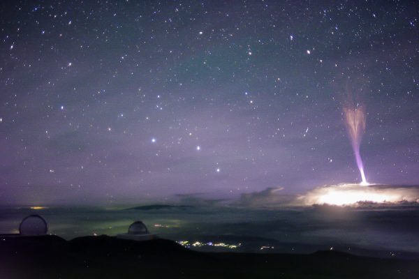
Having an array of cameras on the summit of Mauna kea that capture images all night long has advantages. While the cameras are intended to allow the telescope operators to monitor the weather, they do catch other atmospheric phenomena.
In this case is it a powerful blue jet, a form of upper atmospheric lightning. While these sort of events had been reported for decades, mostly by aircraft pilots, they were only acknowledged by meteorologists after they were first photographed in 1989.
My friend Steve Cullen first noticed the jet in an image from one of the Gemini North CloudCams. It jets upwards from a strong thunderstorm cell passing north of the island, part of the remains of Hurricane Fernanda.
Unfortunately our Keck CloudCam is pointed just a little too west to have captured this event. The next night our camera captures several red sprites, but they are rather distant.
The various cameras capture sprites and jets with a fair regularity anytime there are strong thunderstorms around the islands. If a hurricane is anywhere in the vicinity it pays to check the archives. This jet is bar far the most impressive yet.
Enjoy the image…
A blue jet from a thunderstorm passing north of the island. Original image is a CloudCam image courtesy Gemini Observatory/AURA
Update: On Facebook we were having a discussion about how tall the jet was. I calculated the image scale of the camera, a Canon XTi with a 20mm lens, arriving at about 59 arcseconds per pixel. I also measured the jet as 840 pixels high (there is some extension of the upper part in a hard stretch of the image). Thus the jet is 13.74 degrees high, now all you need is distance to the cell.
Tom Polakis found a good satellite image from the night in question showing the storm about 210 miles away from the summit of Mauna Kea. This and a little trigonometry shows the jet rose about 51 miles above the top of the storm clouds!
The aircraft is rather unremarkable, a standard small jet sitting among many similar aircraft at the Kona airport. It is the NASA colors and the odd pod hanging underneath that belies that this jet is somewhat unusual. This aircraft does not shuttle passengers across the country, it is home to a unique instrument called UAVSAR.
NASA aircraft equipped with UAVSAR podAfter giving the JPL staff a tour of Keck, they reciprocated and offered a tour of their aircraft. An offer that we readily accepted! After three days of watching the jet fly overhead, an opportunity to to see this aircraft up close was not to be wasted.
During this deployment the aircraft has quartered the Big Island, mapping any changes in the landscape on this volcanically active land. The acronym UAVSAR stands for Uninhabited Aerial Vehicle Synthetic Aperture Radar. As the name implies the system is designed to operate from a UAV, but it is currently installed in a crewed Gulfstream III aircraft.
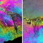
Color-enhanced UAVSAR interferogram images of Hawaii’s Kilauea volcano, image credit: NASA/JPL-CaltechThe system is capable of sub-centimeter accuracy, mapping the surface of our planet with a reconfigurable, polarimetric L-band synthetic aperture radar (SAR). This can reveal precise information about the shape of the land, moisture content of the soil, vegetation differences and more. Making multiple passes of the same area allows study of subtle changes in the terrain due to erosion or volcanic activity. Flying at 12,000 meters (40,000ft) the aircraft must navigate with exceptional accuracy to allow the radar to gather the data. A custom autopilot flies the aircraft through a 33 foot (10 meter) “tube” in the air between two GPS waypoints.
For this mission it is this volcanic island that is the target. As any islander knows we live on a rock that moves. The island settles into the sea, slides into the ocean, and swells where magma pushes its way into the volcano. Each year they return to Hawai’i to re-map the island, this is the fourth year they have returned to check the changes wrought by the volcanoes.
The JPL/NASA folks have completed their mission to the island for the year. Our tour was the morning they were due to depart, flying back to the Dryden Flight Research Center in California.
UAVSAR radar podThe aircraft is not as jammed with electronics as I envisioned. Boarding the plane one finds a few equipment racks and a number of comfortable seats available for the folks that have to tend the electronics through ten hour missions. It is an odd combination of custom electronics built to aerospace standards and off-the-shelf electronics fastened into the racks, including computers, monitors and ethernet routers. Much of the gear is used for simply monitoring the instrument, rather than needed for the radar. One can see how the system could be installed in a smaller UAV.
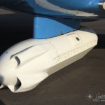
Hanging underneath the aircraft is the pod containing the radar itself. Bright white, the pod sports a flat antenna down the port side for the sideways looking beam. A trio of scoops on the front ram air through the pod to keep the electronics cool.
We chatted with the flight crew and the radar team learning about the instrument and aircraft. They travel all over the US and sometimes around the globe. They have mapped volcanoes in Alaska and Japan, glaciers in Iceland, measured oil spills, and scanned regions effected by major earthquakes. We noted that they had a fascinating job, while they said the same right back at us.
After the tour our hosts kicked us off the plane and began start-up for their hop back to the mainland. We got the data disks with the GPS data we needed for our tests and traded business cards and contact info. I will have to keep my eye out for the results of this year’s Big Island deployment.