Mahukona Harbor

Heading north from Kawaihae there is some of the best diving in the islands. Most of the sites along this rugged coast northern are best dived from a boat. You can reach many from shore, but access can be tricky and a matter of knowing which 4WD road will get you to a usable put in point. There are a couple exceptions where access is easy, the best is Mahukona.

What you find here is a small port from the days when sugarcane and cattle were transported on small steamships that plied the waters up and down the Hawaiian Islands. A substantial pier and other facilities were built in a small cove to serve the north end of the island. A railway terminated here, allowing products to be brought in from much of North Kohala. Most of that is gone now, replaced by good roads, semi trucks and the large port at Kawaihae. What is left is a sleepy little cove with perfect water and great diving.

Exploring the Wreckage
Deborah exploring wreckage from the SS Kauai at Mahukona
The area is a county park used by locals and the few tourists that venture this far north. Camping is allowed by permit and there are some facilities, but maintenance is a little scarce. The large concrete wharf is in decent shape and allows parking right at the water. Do be aware of boat traffic, this is still a harbor. Power boats are unusual here, it is a long way to any boat launch, but we have seen one come into the harbor… once. The usual traffic here are the many kayaks and rowing canoes that use Mahukona as a put-in or pull-out point.

A steel ladder at the top of the wharf provides access right into the water. The access is simply the easiest I have ever used on a shore dive. No sand, no slippery rock, simply a parking lot at the waters edge!


View Larger Map
Google map of the Mahukona dive site, click on the markers and the course line for specific information.

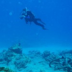
Once you leave the pier head for the center of the harbor. You will quickly find several heavy mooring chains. Large and obvious these chains are heavily encrusted with coral, simply follow them out to the wreck of the Steamship Kauai. The wreck lies in 12-24 feet of water at the center of the harbor.

The engine and propeller are the largest parts to be found and are a little to the north of the large sandy area at the center of the cove. The propeller is in only about 12-15ft of water, accessible to snorkelers as well as divers. Connected to the propeller by the shaft is the large steam engine. This is less obvious when you first see it, but hard to miss once you know what it is. Closer inspection will show numerous pipes, control linkages and the large flywheel at the rear of the engine. Looking into the engine you can see the crankshaft and the numerous fish that find the engine a perfect hangout. Spend some time here, we have found a dwarf moray, blue dragon nudibranch and great fish at the engine.

Scattered out from the engine is a great deal of other evidence of the wreck. The steamship had a cargo of agricultural products and railroad parts when it sank. You will find quite a few wheel sets for narrow gauge rail car use, one is under the engine, others in the middle of the sandy area just seawards of the engine. Cables, piping and ballast bricks are everywhere. A boiler can be found on the north edge of the sandy area, about 4ft in diameter and 12ft long. Check inside to see who is home.

We found three different species of moray eels here, good fish and healthy coral. Not many large fish, fishing and spear hunting is allowed in the area. The small fish area very numerous with large numbers of fry int the shallows and around the wharf.

Mahukona is just about the perfect shore dive site. Park on the pier, and just drop your gear in the water. Shallow diving unless you head out of the cove, but a lot to see in the harbor, you may never make it any further. This site makes for a long shallow dive exploring a little local history.

Geomagnetic Update

The CME from yesterday’s solar flare struck at about 01:00HST, not as strongly as predicted. Right now there is a geomagnetic storm going on, but only at a moderate intensity, Kp=5. It takes something with a Kp>10 before aurora become a likelihood at low latitudes. Expect some nice photos from the folks up north as they get to enjoy the show.

The sunspot responsible for the flare, AR1429, is still there, pointed directly at our Earth. It harbors the energy for more X class flares, stay tuned!

Sun at 304nm
The Sun at 30.4nm (extreme ultraviolet) on 8Mar2012 showing the large sunspot group AR1429 (upper center), image credit NASA/SDO

Geomagnetic Storm Warning

At 00:28UT March 7th (14:28HST March 6th) our Sun let loose with a X5-class solar flare. This is the largest event in many years, and the impact will be felt here on Earth later today. We can expect a major geomagnetic storm when the mass of charged particles strikes the Earth’s magnetic field sometime around 0625UT (±7hr) on March 8th (2025HST March 7th).

Skywatchers at all latitudes have a chance of seeing aurora.

Yes, this means a chance of seeing aurora here in Hawai’i. I have seen aurora in southerly locations, including Tucson at 32° latitude. It is possible given a strong enough event. Fortunately the tropical storm we have experienced for the last few days appears to be clearing out. I will have to check the northern skies this evening.

The culprit is sunspot group AR1429, an enormous magnetic disturbance on the face of the Sun. An enormous amount of energy stored in the twisted magnetic fields of AR1429 was released when the fields ruptured. The result was a powerful solar flare. This event was recorded by several spacecraft at a number of wavelengths. The resulting imagery and movies are worth checking out.

For updated info on the event you can check in with dedicated solar monitoring websites like SpaceWeather or the NOAA Space Weather Prediction Center

Venus and Jupiter

The two brightest planets in the sky will join up for a dance spanning several days starting this evening. Looking up tonight you will see the pair about 5° apart, with the dimmer Jupiter above Venus. Over the next few days they will slide closer, arriving at their closest approach on March 13th, with about 3&deg separation. The pair will remain close for several evenings, on the 14th the distance will have widened to just over 3° and on the 15th the separation will be 3.5°. This is the last dance of the February-March planetary alignment, after this the dancers will go their separate ways.

Mars Close Approach

Mars during the 2005 opposition
Today the planet Mars will be at its closest point to the Earth.

Mars was at opposition two days ago, but not at its closest. Close approach of the two planets is not necessarily on the same day as opposition, but can vary up to two weeks. This year sees the two planets approaching to 99,331,411 km (61,721,554 miles) at 07:01HST. At this distance the red planet will show a disk 13.89″ arc-seconds across in the eyepiece.

All month Mars will be visible throughout the night, high in the sky at midnight. This is the time to enjoy observing our closest neighboring planet while it is nearby and high in the night sky.