
A windswept place of rock and water. A place where the few trees seem bent and twisted. A place with an ancient feel, where time has a different quality. The landscape is bleak, nothing at all like the tourist postcards of Hawaiʻi, open grassland with scattered copses of trees here and there. Look twice and the remains of history litter the landscape. A rubble of stacked stone betrays ancient Hawaiian settlements. Concrete foundations show the more recent remains of wars past or failed farms.
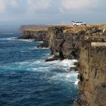
Such is Ka Lae, the southernmost tip of land in the islands. A place where the land and sea meet the past. There is nothing beyond this point but thousands of miles of empty ocean.
This may be the place men first discovered these islands, by Polynesians sailing from the south on those daring voyages of discovery. Many of the most ancient archeological sites are here, on the southern tip of the island. This may be the coastline first sighted by Europeans, Spanish galleons certainly passed south of the islands for centuries prior to Cook’s later discovery of the islands in 1778.
Fishermen have come here as long as men have dwelt in Hawaiʻi. The steep cliffs drop into deep water. A place where the great pelagic fish come close enough to shore to catch without venturing to sea. Ahi, ono, mahi-mahi and other prize catches can be had from a pole at the top of the cliff. On any given day a dozen local fishermen can be found atop the cliff, each with a favorite spot.
The modern technique is to secure a plastic bottle or inflated bag to the line, allowing the wind to pull the line out from the cliff. In years past the fishermen would fish from a boat secured to the cliff by a line. Along the cliff are the remains of winches and ladders used to access the boats.
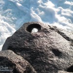
In ancient times Hawaiian canoes would be secured with lines tied to holes carved through outcroppings on the rocky shore. Several of these holes can still be seen today. Drilled through the rock by hand without power tools or even metal bits.
At the base of a white navigational tower is an ancient heiau. A simple stone platform, Kalalea Heiau is a fishing shrine. Offerings here are made to request a safe return from the ocean and a plentiful catch. While many of the old sites are ruins, this heiau is not. The platform is neatly kept, free of weeds and featuring a black gravel platform inside the simple stone wall. Fishermen of all cultures have always been careful to be on the best side of whatever deity controls the sea. The care Kalalea Heiau exhibits shows that at least some hold to the old traditions.
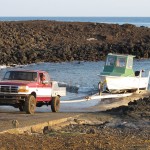
Boats are also used to reach the rich fishing of Ka Lae. Just east of the point is a small boat launch. This ramp is not to be used by the novice boater! Watching the launch procedure gives one a great deal of respect for those who use this boat launch. The waves here can be serious, the cove only offers limited shelter from the open ocean. The shallow waters of the cove requires the use of a long extension on the boat trailer hitch to reach water deep enough to float the boat off the trailer. There is no dock, the boat must be driven by a skilled handler to keep it off the rocks. If the vehicle driver wants to get on the boat after launching there is no choice but to wade and swim out to a boat heaving up and down on the surf.
Remains of an old US Army installation can be found just inland from the point. Originally designated Morse Field this was intended to be a complete US Army Air Force airfield. Construction was started in 1941, then abandoned after the Pearl Harbor Attacks. The field was destroyed to prevent enemy use in the anticipated Japanese invasion of the Hawaiian Islands. The facility was periodically used for other military purposes, including a satellite communication ground station and then a missile tracking station during the 1960’s and 1970’s. All that remains now are ruins, mostly just concrete foundations.
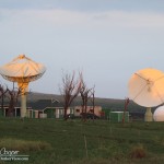
A modern satellite tracking station can be found a few miles up the road from the point. Operated under contract to the European Space Agency the station is part of the ESA tracking station network, Estrack. This network of ground station antennas around the globe allows communications with various scientific and earth monitoring satellites and missions. Two modest communications dishes can be seen over a neatly kept lawn along the road to the point.
Along the clifftop to the east a line of large wind turbines rarely stop turning. The constant wind harvested to serve the power needs of the island. Years ago there used to be two rows of turbines along the road. These are now dismantled, the steel remains piled forlornly where they stood. The Pakini Nui turbines were operational in 2007, supplying 20MW of power to the local grid.
Ka Lae is a beautiful place, a place to be explored with respect for the past. Spend the day walking to Papakōlea Beach (Green Sands Beach) or watching fishermen land an ahi on the cliffs. Far from the palm trees and white sand, a place to see a bit of real Hawaiʻi. The tourists do come here, but somehow there leave little trace of their passing and they rarely get far from the path.

Thank you for the info, I was referred by my friend Micheala Russell