Hawaii Volcanoes National Park has been growing. A few years back the park service purchased much of the old Kahuku Ranch and a couple years ago opened this new unit to the public. Like the main area of the park the Kahuku unit is also a product of the eruptions that shape the island, yet with a totally different character.
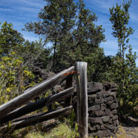
An old stone wall and gate at Kahuku
There is an extensive trail system through the new unit, the old ranch roads converted to walking trails. In addition to the ranching history a visitor can explore the volcanic landscape
On our recent visit we walked one of the easiest trails in the park, the Palm Trail. This two mile loop trail starts near the visitor station and crosses both recent lava flows and rich forested kipukas. Along the way passing relics of ranch history, fences, gates, and an enigmatic diamond D carved into the rock.
Living with active volcanoes about becomes a bit easier if they are properly monitored. The entire island of Hawai‘i is liberally equipped with sensors of various types… Seismographs, tiltmeters, GPS stations, cameras, and gas monitors.
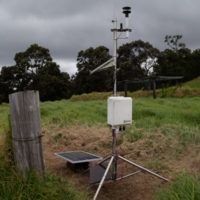
A remote weather and SO2 monitoring station
I came across one of these last instruments on a recent visit to Hawai‘i Volcanoes National Park, the new Kahuku Unit at the south end of the island. While walking in the gorgeous natural scenery of the park, this engineer was instantly attracted to a spindly frame of tubes standing in an old corral.
The Kahuku Cross Fence station is part of the NPS maintained Hawaii SO2 Network with stations throughout the park. The data is provided to rangers and posted on the park website to advise visitors of volcanic gas hazards while visiting the volcanoes.
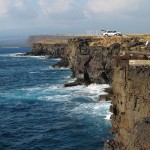
A picture postcard perfect setting… Brilliant blue water, waves crashing on black rock, palm trees overhead, the old pier jutting out from shore. Whittington Park is a beautiful stop along the Mamalahoa Highway as you round the south end of the island.
The old pier at Honu‘apo slowly succumbs to the battering surfLike Mahukona at the north end of the island, this is an old sugar port. Here the small inter-island steamships loaded cargoes of Ka‘u cattle and sugar bound for Honolulu and shipment to markets across the Pacific. Bulky cargoes are best transported by water, thus these busy little ports were once found across the islands, today only a few ruins remain.
Honu‘apo Pier in 1908Known as Honu‘apo, or turtle cove, the port served area ranchers and plantations until the middle of the twentieth century, when better roads and trucks allowed shipments to the port in Hilo. Numerous ruins remain, seen in the wave battered pier, scattered foundations, and the ruins of a sugar mill across the highway. The pier has been destroyed and rebuilt several times, pounded by winter storms, once blown up by the army to prevent use during a feared Japanese invasion.
A large pond and wetlands sit alongside the mown lawn at the center of the park. Once maintained as a fishpond by ancient Hawaiians it is now a rich marsh. The park encompasses over half a mile of shoreline and over two hundred acres of land. There is plenty to explore along the shore north of the main park. Numerous archeological sites scattered across the low coastal plain testify to the centuries of use, from a large pre-contact village, to the plantation operations of the 19th and 20th centuries.
It is a pretty park with decent facilities. Camping is available here with a permit that can be purchased online. Stop by and enjoy the scenery and have lunch. Much of the time this beautiful park sits empty, the isolation of this coastline exemplified.
A windswept place of rock and water. A place where the few trees seem bent and twisted. A place with an ancient feel, where time has a different quality. The landscape is bleak, nothing at all like the tourist postcards of Hawaiʻi, open grassland with scattered copses of trees here and there. Look twice and the remains of history litter the landscape. A rubble of stacked stone betrays ancient Hawaiian settlements. Concrete foundations show the more recent remains of wars past or failed farms.
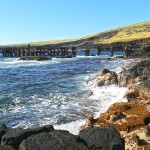
The cliffs of South Point drop into a deep blue Pacific Ocean
Such is Ka Lae, the southernmost tip of land in the islands. A place where the land and sea meet the past. There is nothing beyond this point but thousands of miles of empty ocean.
This may be the place men first discovered these islands, by Polynesians sailing from the south on those daring voyages of discovery. Many of the most ancient archeological sites are here, on the southern tip of the island. This may be the coastline first sighted by Europeans, Spanish galleons certainly passed south of the islands for centuries prior to Cook’s later discovery of the islands in 1778.
Fishermen have come here as long as men have dwelt in Hawaiʻi. The steep cliffs drop into deep water. A place where the great pelagic fish come close enough to shore to catch without venturing to sea. Ahi, ono, mahi-mahi and other prize catches can be had from a pole at the top of the cliff. On any given day a dozen local fishermen can be found atop the cliff, each with a favorite spot.
The modern technique is to secure a plastic bottle or inflated bag to the line, allowing the wind to pull the line out from the cliff. In years past the fishermen would fish from a boat secured to the cliff by a line. Along the cliff are the remains of winches and ladders used to access the boats.