
I believe I have said it a few times here… I love ruins. And while good ruins are fewer in Hawaii, southeast Alaska has plenty to explore.
For one reason or another, fate seems to highlight this odd cove every time are in the area. From the first time I noted the unusual name on a chart to the halibut we have routinely caught here. Once when we simply planned to cruise by some odd activity caught my eye, again leading me into this place. Changing course we discovered whales bubble net feeding along the southern cliffs, a sight I will not soon forget.
The odd name is from the Tlingit, Iyukin, and was first recorded in 1869 by G. Davidson, U.S. Coast and Geodetic Survey. This name was accepted and was published in the 1883 edition of the Coast Pilot, to be shown as Iyoukeen on nautical charts ever since.
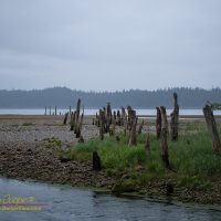
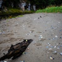
A sand and gravel beach backs much of the cove, with steep hills behind. An odd, very narrow, rocky peninsula separates the cove from Freshwater Bay to the south. Cruise ships, ferries, and fishing boats pass by taking little heed of this seemingly unremarkable cove.
Another feature of the cove is a set of pilings leading up from the beach to a small stream that enters the cove at the middle. I have wondered about those pilings a few times, and that wondering led me to explore.
The 2017 Mission
The plan is simple… You have fun fishing halibut for a few hours, I am taking the launch up to the beach to see about those pilings. Following odd pilings has led us to fun discoveries on a number of occasions.
There was some sort of large wharf here at one time long ago. What was it? Why here?
Walking up the beach from the far end of the wharf raised a lot of questions in my mind. Iyoukeen Cove is not very protected, the often nasty weather that blows up the long north-south reach of Chatham Strait could easily pound this beach with the right winds. We have experience Chatham’s moods more than a few times, it can be bad.
The site also needed a very long wharf to reach deep water, a few hundred yards! There are much better sites for a cannery nearby. Pavlof Harbor? Cedar Cove? Why build here?
Extended human habitation usually leaves a lot of trash about. Bits of metal, glass, or ceramics in the stream bed on along the rocky tide-flats will survive for a century or more. What I did find was obviously far more recent than the wharf, a few Fanta bottles and some floats. As I returned to the launch I was left with no real answers.
Having spent less time than planned searching the site I found the launch well above low water. It was necessary to drag it twenty feet down the gravel beach to re-float and return to the Quest. In no hurry I swept along the beach to the south with the launch, at least until the kelp was too thick to negotiate closer to the peninsula of North Passage Point.
I returned to the boat just in time to photograph my father landing two nice halibut. At least they were having more success than I did. Still, it was nice to get out and hike about in the woods a bit.
My exploration turned up very little, leaving a bit of a mystery why this wharf was built. A little searching online also revealed nothing, no evidence of a cannery at Iyoukeen.
It was later the next day, talking to a local friend in Tenakee about the old pilings that we got a vital clue. He remembered that the cove was home to a gypsum mine about a century ago, that the wharf most likely belonged to the mine. A mine rather than a cannery would explain a great deal!
Pacific Coast Gypsum
Adding the keyword ‘gypsum’ to a Google search popped up a wealth of information on the site. The wharf was indeed built to service a gypsum mine about a mile up the valley. A mine would explain the location, the wharf would have to be built as close as possible to the mine workings to avoid the need for hauling heavy bulk cargoes a long distance.
The mine had left its marks on the map. Unlike the marine maps we had on-board that left the creek anonymous, the USGS topo maps showed that the stream was named Gypsum Creek, and some showed an abandoned town site named Gypsum at the shoreline.
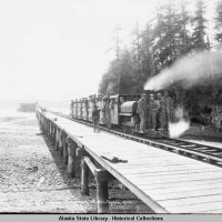
Those Victorian homes in Seattle and San Francisco built with lath and plaster? That plaster may have been made with gypsum from Iyoukeen, half a million tons were shipped out during the productive life of the mine from 1906 to 1923. In 1923 the mine flooded and the operation was never reopened.
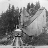
The worst after-the-fact discovery is that there appears to be a complete narrow gauge locomotive lying in the creek, probably not far upstream from where I explored. The photos show a flat creek bed, most likely before the creek starts climbing into the valley, just above tidewater. Apparently the locomotive was left sitting on a siding that has since been eroded out by the stream, tumbling the remains into the creek. Yeah, need to go back and find it!
The 2018 Mission
Another chance to explore the old mine? Yes please! Our 2018 trip was to proceed down Chatham Strait past Iyoukeen cove. Why not execute the same plan? Fish for halibut while a shore party explores the mine ruins and looks for the locomotive.
This time I was not alone in my shore expedition, my aunt and uncle and friend Peggi rode the launch into the beach. My uncle has spent a lifetime walking in the woods as a forester, I appreciate having his experience to draw on for a jaunt like this.
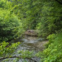
When we got to where the stream leaves the woods we found some concerning signs. Not ruins, but rather signs of a more recent resident. First there were large, but unidentifiable prints in the soft sand near the small cliffs… Human? Maybe?
Further in the next set of tracks I find across the sandy bank of the stream are totally identifiable…
Grizzly.
The tracks are not fresh, they have been rained on, but they are not that old either. There is a bear here.
Looking about I find some remains of the bear’s meals, a few salmon jawbones lying along the stream. This is not a good salmon stream, too small for a substantial run of fish. This bear is eating the heads and tails, parts of the fish bears will usually leave for the gulls.
There are four of us, we have bear spray, we cautiously proceed. The ladies are still out on the beach as Richard and I push through the brush into the forest. The path of the old rail line is immediately clear, a wide swath cut through the trees proceeds inland, back into the forest there is almost no underbrush, the rail line will be easy to follow. Yes!
Is that what I think it is? Movement catches my eye, it is moving through the brush just ahead. Yup, it is exactly what I think it is. The radio crackles as Peggi exclaims that they have found more bear prints. “Yes, Peggi… We found the bear.”
I look at the bear, it looks at me. The bear does not run off immediately like most bears do when challenged like this. As we consider each other I realize this bear is big, lean and lanky. This late in the summer the bear should be fat from eating salmon for several months. Lean and probably hungry, I just get all the wrong vibes from this particular bear.
Time to leave.
Any further exploration of the Gypsum Mine at Iyoukeen will have to await another opportunity, another year.

Smart move dude!