Around this island the observant hiker will become attuned to various clues that give a view into the natural history or human history of the landscape.
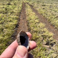
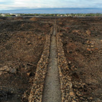
An ʻopihi shell found along a utility line access road far from the ocean
One such clue is the presence of seashells, these are usually a giveaway of ancient Hawaiian occupation of a site or locality. The bleached and broken bits of shell a long lasting remant of meals harvested from the shoreline and brought to places well inland. Often found around lava tubes or water sources these shells let you know that others have passed here before.
An ʻopihi shell along a power line access road near Waikoloa? This is a bit unexpected. I have to stop and pick up this shell, stopping to puzzle out this anomaly.
The region south of Waikoloa along the shore seems to be a barren field of lava with little to offer beyond miles of dark rock and baking sun. That may seem to be the case, but there are surprising gems out in those lava fields.
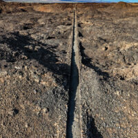
Looking along the King’s Trail south of Waikoloa
The plan? As usual hike the King’s Trail south from Waikoloa, but this time explore some of the smaller trails I had passed by in the past. Perusing the satellite imagery reveals a surprising number of trails through the lava. Considering the substantial effort it takes to cut a trail through the worst aʻa lava those trails must be significant somehow.
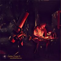
Wandering the sky using a telescope and a field guide published in 1844, the better part of two centuries ago, is… uhhm… interesting. In mid-April the classic winter constellations are dissapearing into the sunset, with constellations like Monocerus and Puppis well placed for observing from my driveway just after dark. On my observing table is a reprint of that 1844 field guide, The Bedford Cycle.
At the telescope in the driveway again
Working through the entries I come to the entry for a double star Argo Navis 72 P. VIII, a designation from a very old catalog. It takes a few moments research to convert 72 P. VIII to the slightly more modern catalog number HD 71176. Modern? The Henry Draper Catalog was first published by Harvard Observatory in 1918, still over a century ago.
With the HD number I can look up the position on a modern chart and spend a few moments star-hopping the Astrola to the correct star. This double star is now located in the constellation Puppis after the ancient and absurdly large constellation Argo Navis was broken up into Puppis, Vela, and Carina.
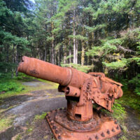
Yakutat, like several other towns and cities along the Alaskan Coast was fortified during World War II to prevent occupation by the Japanese. Many remains of this military station are still there to be found by those willing to poke about a bit.
A six inch gun emplacement from World War II at Cannon Beach, Yakutat
Some of the remnants are well known about town. The long ocean beach in front of the town is called Cannon Beach for an obvious reason, two six inch gun emplacements are still present in the trees behind the beach, guns included.
The barrels have been torched off to deactivate these military weapons, but they are still there. There were additional gun emplacements on the point protecting the settlement and harbor, but these guns were removed with only the emplacements remaining.
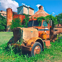
The impact of the sugar industry in these islands simply cannot be overstated. For over a century sugar was the dominant industry in the islands consuming land, water, and people. These islands were shaped by sugar, physically and culturally.
An abandoned truck sits outside the Kōloa sugar mill
So much of what you see today is a direct resut of sugar, many people and cultures that now call these islands home are descended from the immigrant laborers who came to work the plantations. These immigrants brought with them thier languages and so much more. So many traditions, foods, and words, blended with the Native Hawaiian culture to create the island culture we enjoy.
While this legacy is seen on almost all of the islands it seems most visible on the southern shore of Kauai, perhaps as these plantations were some of the last to shut down, and very little has replaced or re-developed in the area. Plantation towns sit in the shadow of rusting mills that loom over the landscape.
Lives are often measured by the great events that take place during our short spans of existence. Wars, revolutions, social movements, mark both the great saga of human history as well as our personal stories.
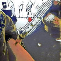
Syringes loaded with SARS-CoV-2 vaccine await use at a vaccination clinic
The COVID pandemic will certainly be such an event. An event with worldwide impact, so many changes, so many lost.
While the start of the pandemic was slow, the events unfolding over weeks and months, I can mark it’s end as today. At least in a personal sense. Today I received my second dose of the Moderna vaccine, a moment I will likely remember, a moment that forever marks my personal journey.
Receiving the second dose of SARS-CoV-2 vaccine
This pandemic is not done, with me or the world at large. The pandemic will still have impacts, and the deaths continue, years from now when I look back this moment is where I will likely consider it done, at least in a personal sense.
For much the last year Deb and I have lived quietly, marking time, staying home. Re-discovering the small joys in life… Cooking, gardening, spending time under the stars with a telescope.
Time to move on with life. The timing seems even more appropriate in that I start a new job on Monday. I can plan for events more than a few weeks away, even consider some travel further than the shores of this small island.
It may not be over, but in my life, in my mind, it is over.
Rather than spend the evening obsessing over election results I opted to take a hike. Nothing dramatic, just a short loop hike close to home, along the shoreline south of ʻAnaehoʻomalu Bay .
Looking north the Waikoloa Resorts along the King’s Trail
The plan was to use the King’s Trail to quickly hike a couple miles out, then to take my time hiking back along the shoreline. I timed my start so that sunset would occur while I was coming back along the beach.
While this section of the King’s Trail is over 150 years old, it is in excellent condition and allows easy hiking across the lava fields. The trail cuts absolutely straight over the ridges and tumuli of piled rock, much faster than slogging through the beach sand.
I had hiked the shoreline here many times, but had not hiked any real length of the King’s Trail. The trail crosses the lava flows well above the coastline, as a result it can be brutally hot under a tropical Sun, while the shoreline offers regular shade and a cool ocean breeze.
This particular election day evening the Sun was muted by a broken overcast sky. Why not use the trail?
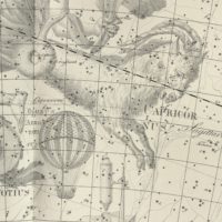
As I worked my way through the evening’s observing list I came to an entry for the asterism ‘Hot Air Balloon’
A detail of Plate 16 of Uranographia by Johann Bode (Berlin, 1801) with Capricorn and Globus Aerostaticus
This asterism found its way into my personal observing catalog from the one of the Saguaro Astronomy Club observing lists. These lists are an excellent resource for those who roam the starry sky, sort of an ultimate best-of list. These lists are one of the many sources I pulled together when creating my own giant list of where to aim my telescope.
So often I find surprises in my own database among the thousands of objects that I have dumped in there over the years.
Asterisms are simply odd patterns of stars that form memorable groups, but are not necessarily real clusters or other stars that are physically associated with each other. Many of these are well known such as The Coathanger, the Diamond Ring around Polaris, or The Stargate.
When I wandered through the coordinates listed from the Balloon I found a pretty starfield, but nothing that stood out as a recognizable shape, much less a balloon. I wrote down a few comments on the area and a note to myself to look this up later. What is The Balloon?
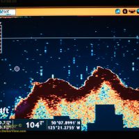
Seymour Narrows is a bit of water one approaches with caution. This narrow passage north of Campbell River provides the shortest route between Vancouver Island and the mainland for transiting vessels. This passage is also subject to dramatic tidal currents of up to fifteen knots.
The strong currents create large areas where the water seems to boil, dotted with whirlpools and debris swept along by the rushing water. The result is what explorer Captain George Vancouver described in his logs as “one of the vilest stretches of water in the world.”
The remains of Ripple Rock well beneath the surface in Seymour NarrowsAs usual we had anchored and waited a couple hours for the tide to change, waiting for the worst of the currents to slack. While small, fast boats can pass by during high current, most vessels wait for the tide here. We were not alone, when we pulled anchor and nosed into the narrows we joined a parade of boats that had waited.
The passage was once much worse, a large rock named Ripple Rock lurked just under the surface at low tide. This mid channel rock created huge standing waves and vicious eddies as the current ran over it.
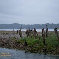
I believe I have said it a few times here… I love ruins. And while good ruins are fewer in Hawaii, southeast Alaska has plenty to explore.
Old pilings across the sand and gravel from Gypsum Creek into Iyoukeen CoveIyoukeen Cove, is a place we have been many times. We have fished halibut here more times than I remember, doing fairly well, a favorite spot. A few years back we landed a 205 pound fish here.
For one reason or another, fate seems to highlight this odd cove every time are in the area. From the first time I noted the unusual name on a chart to the halibut we have routinely caught here. Once when we simply planned to cruise by some odd activity caught my eye, again leading me into this place. Changing course we discovered whales bubble net feeding along the southern cliffs, a sight I will not soon forget.
The odd name is from the Tlingit, Iyukin, and was first recorded in 1869 by G. Davidson, U.S. Coast and Geodetic Survey. This name was accepted and was published in the 1883 edition of the Coast Pilot, to be shown as Iyoukeen on nautical charts ever since.
Google Map of Iyoukeen Cove and Gypsum CreekLocated on the west side of Chatham Strait, the cove is a wide open reach of water, unprotected from the wind and waves that can rage up the strait.
A sand and gravel beach backs much of the cove, with steep hills behind. An odd, very narrow, rocky peninsula separates the cove from Freshwater Bay to the south. Cruise ships, ferries, and fishing boats pass by taking little heed of this seemingly unremarkable cove.