
The region south of Waikoloa along the shore seems to be a barren field of lava with little to offer beyond miles of dark rock and baking sun. That may seem to be the case, but there are surprising gems out in those lava fields.
The plan? As usual hike the King’s Trail south from Waikoloa, but this time explore some of the smaller trails I had passed by in the past. Perusing the satellite imagery reveals a surprising number of trails through the lava. Considering the substantial effort it takes to cut a trail through the worst aʻa lava those trails must be significant somehow.
Starting early I find the Anaehoʻomalu Beach parking lot nearly empty, the day’s beach users have not yet arrived. No surprise as the Sun has barely made it over the shoulder of Mauna Kea. The cool morning should make for a pleasant start across the lava fields.
I stop first at Keahualono, the boundary ahu between three Ahupuaʻa, Hawaiian land divisions… Waikoloa, Anaehoʻomalu, and Puʻuanahulu. A substantial edifice of piled rock likely placed here by the storied aliʻi Lonoikamakahiki. From the ahu I travel a small fragment of traditional trail that cuts across to the King’s Trail, the first new exploration of the day.
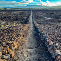
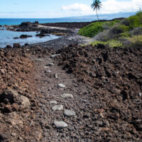
The King’s Trail slices straight across the lava flows, impressively straight, a modern survey crew would be tested setting a path so straight across that rough landscape. With an excellent roadbed this trail is an easy walk through an area where otherwise travel would be reduced to a hazardous crawl by the piles of loose and sharp rock. On the trail I quickly travel the first mile and a half.
I turn onto a modern access road towards the sea, a driveway that crosses state land to an old estate along the shoreline, this will serve to cut over to another traditional trail I had spotted on the satellitel imagery.
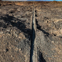
This second trail turns out to be a bit of a surprise, what was a faint trace in the satellilite image turns out to be a substantial trail built in the old style with smooth water worn cobbles set as stepping stones through the rough aʻa. The trail angles across the lava from a beach to an anchialine pond, a splash of vibrant green in the middle of the expanse of jagged volcanic rock.
These ponds are places where the water table, essentially at the same level as the nearby ocean, is exposed by low lying terrian. Closer to the sea these can be brackish, but this one is mostly fresh water. The clean fresh water probably explains the excellent trail, built to allow the fishing settlements along the shoreline access to that water.
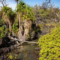
An oasis it is, lush growth of naupaka and pandanus create an idyllic setting. Small fish swarm the shallow sandy pool and dragonflies buzz about. I pull off the pack and take a quick break here, just enjoying the unexpected contrast with the surrounding lava.
Scattered around the oasis are stacked stone walls, some are substantial, others rough circular enclosures about six or seven feet in diameter. Checking the satellite imagery later I find that no less than four trails converge here. Eventually I must leave, taking the trail that heads directly to the shore, coming out at Pueo Bay.
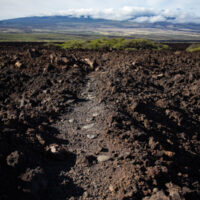
In places the ancient trail along the coast is quite good, the smooth stepping stones pleasant even in boots. In several sections it drops to the beach and I slog though sand, in other places the old trail is in poor repair with loose cobble threatening to turn an ankle.
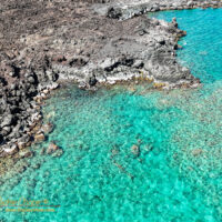
The coast here is simply beautiful, small black sand beaches, low sea cliffs of black lava dropping into tourqiuse water. In one spot I note pockets of salt water drying out in the sun, natural sea salt available for seasoning your poi or fresh caught manini.
About halfway back I reach one of my primary targets and one of my favorite places on this coast, the freshwater pool at Akahu Kaimu. Here I drop the pack again, stripping down to a swimsuit for a cool dip. It has been hours since dawn and the start of this hike, the morning has grown hot and the cool waters are very welcome.
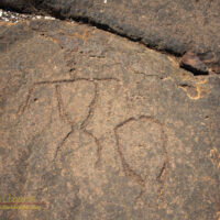
From here it is a direct walk along the shore to the beach parking. I do stop and wander the petroglyph field at Kapalaoa. I find that the rusting Sampan diesel engine along Anaehoʻomalu Bay has been moved again by the surf over the winter, sitting higher on the beach and more exposed.
The last mile along the beach offers no lava trail to avoid slogging through the sand. I wonder about this since otherwise the ancient trail network is well developed offering good paths to avoid such difficult spots. I suppose that whatever trail there once was is buried under the large thickets of naupaka or under the sand dune that backs the beach along this section.
Once back home I again check the satellite imagery and retrace my path, I had covered about five miles. Though with all of the loose rock and sand it was probably the equivalent effort to seven miles when tallied. A good day’s hike, my ankles and calves are protesting the abuse of rock and sand, but worth it.

Walked a bit of that in 2016. Magic!
https://happening-here.blogspot.com/2016/01/saturday-scenes-and-scenery-kings-trail.html