The region south of Waikoloa along the shore seems to be a barren field of lava with little to offer beyond miles of dark rock and baking sun. That may seem to be the case, but there are surprising gems out in those lava fields.
Looking along the King’s Trail south of Waikoloa
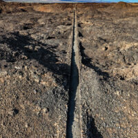
The plan? As usual hike the King’s Trail south from Waikoloa, but this time explore some of the smaller trails I had passed by in the past. Perusing the satellite imagery reveals a surprising number of trails through the lava. Considering the substantial effort it takes to cut a trail through the worst aʻa lava those trails must be significant somehow.
A long weekend? Cloudy enough to preclude a night with a telescope? May as well take a walk.
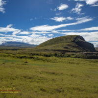
Puʻuhinai with a snow capped Mauna Kea behind
There are a few great hikes around the island, but often I just do not feel like driving very far. Thus I head out to Puʻuhinai again, one of my favorite local hikes just outside the village.
Recent rains have turned the landscape green and lush. Everywhere there are signs of flowing water, even along many of the old ranch roads, the downpours have been intense lately. The mauna have had snow all year so far, a reminder of a very wet winter rainy season.
Rather than spend the evening obsessing over election results I opted to take a hike. Nothing dramatic, just a short loop hike close to home, along the shoreline south of ʻAnaehoʻomalu Bay .
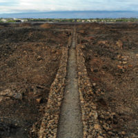
Looking north the Waikoloa Resorts along the King’s Trail
The plan was to use the King’s Trail to quickly hike a couple miles out, then to take my time hiking back along the shoreline. I timed my start so that sunset would occur while I was coming back along the beach.
While this section of the King’s Trail is over 150 years old, it is in excellent condition and allows easy hiking across the lava fields. The trail cuts absolutely straight over the ridges and tumuli of piled rock, much faster than slogging through the beach sand.
I had hiked the shoreline here many times, but had not hiked any real length of the King’s Trail. The trail crosses the lava flows well above the coastline, as a result it can be brutally hot under a tropical Sun, while the shoreline offers regular shade and a cool ocean breeze.
This particular election day evening the Sun was muted by a broken overcast sky. Why not use the trail?
A little drone footage, a lot of stills. With the drone, the phone, and the little mirrorless M5 I was carrying three cameras for the morning. Most of my daypack was camera gear, along with a small first aid kit, 1/2 gallon of water and iced tea, and munchies.
I seem to have solved some technical issues that plagued my videos from earlier this year. Using a ND32 or ND64 filter really does help slow shutter speeds in full sunlight. You can see some choppiness in the faster pans, but that is mostly from using 30fps for the final rendering rather than in the source.
What did cause trouble is the vibrant greens of Puʻuwaʻawaʻa, some shots came out muddy yellow-green. Need the check how I am setting the white balance in the drone, need to use fixed sunlight rather than auto.
While the beaches may be closed during the pandemic, most of the trails are open. Deb and I did a little walking on the Puʻu Oʻo Trail while coming back over the hill from Hilo.
Nothing unusual to report, no rare native birds. As the ʻōhiʻa are not in bloom few birds were in evidence. Even without blooms or birds this is always a pretty trail, a rugged landscape over recent lava flows and the pioneer plants found on these flows.
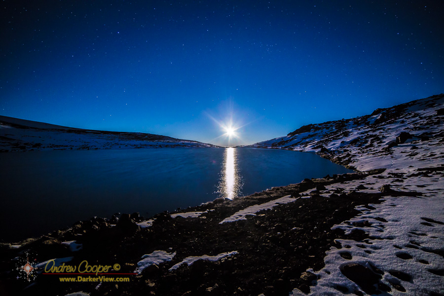
Sublime… One word in the English language that comes close… A frozen world of snow and ice, dark rock, illuminated by ethereal moonlight. A place more of the arctic than a tropical island. Recent storms have again created such a place on the summit of Mauna Kea. Just need to make a point to get out there and enjoy it.
A nearly full Moon setting over lake Waiau near the summit of Mauna Kea
The plan? Set the alarm clock for 2am, out of the house before 2:30am, arrive at the trailhead about 3:45am. I would take a walk with a camera, then drive back down to Hale Pōhaku for breakfast, then join the crew for a normal day working on the summit. A good plan, if somewhat exhausting. A plan that was executed exactly as originally envisioned.
It was the timing that was the factor here. A few things to come together to make this work… A good covering of snow, the summit road open to the public, and good weather with clear, starry skies. Clear skies have been in rare supply lately, a succession of winter storms bringing weeks of clouds.
The road being open to the public is also an important bit. While I could drive past the roadblock, the rangers know me, we are forbidden to engage in non-work activities on the summit if the road is closed to the public.
The needed factors came together this particular morning and I set the plan into action.
The original plan had been to hike Puʻu Kole, a dramatically red cinder cone visible from the summit access road. The red coloration leads to the name, Kole, which translates as red.
What actually happened is that I climbed the wrong puʻu.
The vehicle parked on the side of Mauna Kea with a snow covered Mauna Loa in the backgroundPuʻu is Hawaiian for hill and is generally used to refer to the many cinder cones that dot the landscape of this volcanic island. As prominent landmarks these hills are used to describe the land, and can be found as references in the old land surveys. Every prominent puʻu has a name. The summit of Puʻu Kole is used to define the modern Hamakua and Hilo district boundaries.
As I traversed the R1 4WD road the side of Mauna Kea was enveloped in heavy fog, thick enough that you could not see a hundred yards, sometimes less. I was pretty sure I was in the vicinity of the target, and sure enough the shadow of a large puʻu was visible in the mist. So I parked the vehicle and climbed it.
It was when I reached the top and looked downhill that I noted there was another puʻu hiding in the fog. It was then I realized that I might just be on the wrong hill. Checking the maps I realized that I had climbed Puʻu Palaolelo.
Wrong? Perhaps this is the wrong word, there was no particular reason I needed to be on the right puʻu other than my desire to explore a place I had seen so often while ascending or descending the summit road. The error was fortuitous in that my original target hill was enveloped in thick fog all morning, while Puʻu Palaolelo, a little higher on the mountain, was alternately in the fog and in the sunlight.
A beautiful fogbow, a glory and the spectre of the brocken on Puʻu PalaoleloIt was this play of fog and sunlight that led to the most dramatic experience of the day. When I neared the summit a beautiful fogbow appeared. Even better, when the angle of the sunlight and the steep slope of the puʻu allowed a glory and even a spectre of the broken appeared in the fog.
Standing atop the puʻu I could not miss the beauty of the morning. Still early the low sunlight was rich in color. Across the saddle you could see Mauna Loa, capped in vivid white, quite a contrast to her black lava flows. A chill wind swept fog over the summit, at times I was spattered with droplets. As the fog and light played across the landscape my camera memory card quickly filled. It was a satisfying hike, resulting in some pretty photos. My original goal of climbing Puʻu Kole lies unfulfilled, an excuse for another walk on the mountain.
Getting close to flowing lava is a great experience, but one that is fraught with risks. Sometimes the lava is relatively easy to access, near a road or developed trail. Most of the time it takes a serious hike across the old flows to get near, an arduous trip with no trail or map to guide you.
An active pāhoehoe breakout at Kupapa’u
My most recent hike was my fifth trip out to the flowing lava, requiring my longest hike over the flows to date at just under three miles each way. OK, maybe I am not yet a veteran, but these trips have taught me a lesson or two. Going onto the lava is an inherently risky proposition and one must accept that risk. With a little knowledge and preparation the risks can be mitigated. Besides, the reward is spectacular!
You can take my word for it, or perhaps read the same information from someone who has been out far more than I. We will all tell much the same story.
The lava has been entering the sea for over a month now. I have wanted to hike out, but life and other commitments have consistently intervened. With off-island guests, I made the offer to lead a hike out to the flowing lava. My sister-in-law Darcy was the only one that took me up on the offer, the prospect of a 2am wake-up and a two hour trek across rough ground too much for some. We left the others in bed.
A active pāhoehoe breakout at Kupapa’uThis is the same plan I have used before, a two hour run across the island to Kalapana gets us to the edge of the flow field about 4am. This leaves another two hours to hike to the lava flows. We would need the time! It would take all of that two hours to make just 2.7miles. Two hours over the rough ground of older lava flows, avoiding pits, loose plates, large cracks and small hummocks that rose 10-20feet overhead. This was in pitch black conditions with no moonlight to help. It was alternating bright stars and clouds overhead, two brief showers left us dampened but comfortable in the warm tropical dawn.
