This old Land Cruiser had it’s issues… You had to jiggle the gearshift to get the vehicle into reverse. If you rolled the driver’s window up all the way it would roll itself right back down again. The key would only work one side up in the lock despite it looking exactly the same on both sides. It rattled and clattered alarmingly on rough roads. And I loved it.
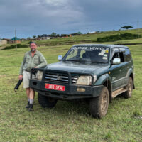
That old Toyota Land Cruiser was just the right vehicle for the job.
Through the mud and ruts, up the side of a mountain, through thunderstorms and washed out roads, across an entire country… This green beast got me there. With this vehicle I enjoyed experiences that will become memories treasured for a lifetime.
Continue reading “The Right Vehicle for the Job”