I do like exploring volcanoes. As I live on an active volcano, with three other active volcanoes visible on the horizon, this sort of exploration is something I am regularly able to indulge myself with. The fifth nearby active volcano can not be seen from home, it takes a two hour drive to reach, a worthwhile trip as it is the one that is currently erupting. Since I have so many volcanoes in my life why would I want to visit another one? Because I love volcanoes!
Looking down on the plume of volcanic gasses issuing from Santiago Crater at Volcán MasayaMasaya is an active volcano just south of the capital of Nicaragua. It is part of a chain of volcanoes that dominates the landscape of the country. It is also easy to reach, part of a national park just a few miles off a major highway. You can drive right to the crater rim and look down into the pit.
While Masaya is not currently hosting any major activity it is home to an ephemeral lava lake and emits a steady plume of volcanic gasses. In many ways it is similar to visiting the Halemaʻumaʻu crater at Kilauea, a large pit with a plume of gasses. Like Halemaʻumaʻu, these craters are part of a larger volcanic edifice. There are three pit craters including San Fernando, Santiago, Nindiri and San Pedro that occupy the top of a complex of cones at the center of the caldera. The Masaya caldera is about seven miles wide with a large lake at the southeastern end. The last major eruption and lava flow was in 1670, with current activity confined to outgassing and the occasional ash plume.
XKCD has been on a roll lately. OK, when is Randall not on a roll? Perhaps it is that several of the latest directly address astronomy, with this last one hitting closer to home than usual. How often do I stand in front of a crowd talking about the stars? Plus, I am not really an astronomer…
XKCD comic “Stargazing” by Randall Munroe, creative commons license
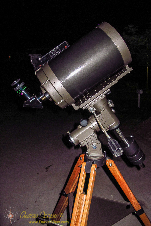
I still have an 8″ solar filter on-hand, leftover from the Meade LX50 I used to have many years ago. A quick inspection to insure it is in usable condition (take no chances with solar filters) and a fit check… It fits the restored C8 perfectly.
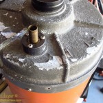
It looked horrible! The paint was coming off everywhere with heavily corroded aluminum underneath. Most of the screw heads were small balls of rust, with hopefully enough remaining to fit a screwdriver to and remove. For a precision optical instrument this small telescope was not very encouraging.
Looking at what remains of the paint on an old Celestron C8 orange tube telescopeOn the bright side the optics looked to be in decent shape. While there was some dirt and mold on the corrector, the primary looked almost perfect. Not bad considering the condition of the metal parts. Maybe, just maybe, this telescope is salvageable.
The telescope in question is an old orange tube Celestron C8. Thousands of these little telescopes were manufactured in the 70’s and 80’s. It was the C8 that set the standard for amateur telescopes at the time. The C8 is still in production forty years later, but the tubes are no longer painted orange as they were originally. Compact, yet offering decent performance, these telescopes were well regarded and hold a special place in the memories of many amateur astronomers. I have seen these little orange telescopes at dozens of star parties, even bolted to the side of huge professional telescopes for use as finders.
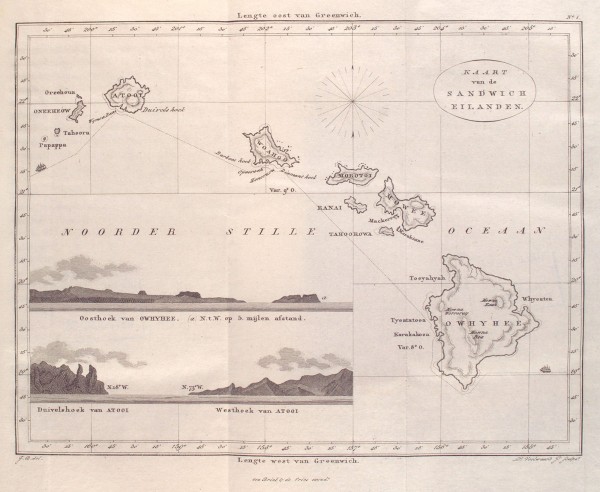
Among the items I found in the NYPL image collection was an 1835 map of the Hawaiian Islands. I included it in the posting on the collection, but the map truly deserves a closer look. It preserves the western view of the islands as of the early 19th century.
The map is reasonably accurate, looking at the coordinates given for key points in the islands shows that they are correctly plotted. The outlines of the islands are mostly familiar. The shapes of Molokai, Maui, and parts of Hawaiʻi do show some odd features that look odd to anyone with a good knowledge of local geography. Any number of points and bays seem exaggerated, note the peninsulas on the north shores of Oahu and Maui. Notably Kealakekua bay is drawn as much more sheltered than it really is, an odd inaccuracy in a maritime map.
Continuing inspection reveals a number of other oddities… There are two islands marked on the map south of Niʻihau, named Tahoora and Papappa. Modern navigation maps mark only one island here, Kaʻula. Tahoora (Kaʻula) was spotted by the Cook expedition and recorded with that name. Reference to Papappa can be found in the 1870 Seaman’s Guide to the Islands of the North Pacific, Part II, W. H. Rosser. Apparently local fisherman reported another island south of Kaʻula. A number of ships looked for such an island in vain. The guide lists its existence as “doubtful”.
Map of the Sandwich Islands (Hawai’i) issued in 1835 by Jacobus Boelen
It is also interesting to note that the coordinate system used is referenced to Greenwich. Thus the longitudes marked at the bottom match those found on modern maps. At the time the prime meridian, the location of zero longitude, was hotly contested between several possible locations. It was not until the 1884 International Meridian Conference that Greenwich became the accepted standard worldwide. This was over the objections of the French who abstained from the vote and continued to use the Paris meridian until 1911.
Of course it is the place names that are the most fascinating feature of the map. Setting aside the Dutch vocabulary and looking just at the transcriptions of the Hawaiian place names one sees familiar names as they were used two centuries ago.
Looking about the map one will note Owhyhee in place of the modern Hawaiʻi, Mowee and Woahoo as the old versions of Maui and Oaho, quite recognizable. If you have read the old accounts you may recognize Atooi as the island of Kauai. We also see Mowna Kaah printed on the map for present day Mauna Kea, similar to the Mauna Kaah found in the Cook expedition journals as the first written version of the mountain’s name.
Map Name
Current Name
Atooi
Kauai
Honoruru
Honolulu
Karakakooa
Kealakekua
Mowna Kaah
Mauna Kea
Mowna Worroray
Hualālai
Mowna Roa
Mauna Loa
Morokinne
Molokini
Morotoi
Molokai
Mowee
Maui
Oneeheow
Niʻihau
Oreehoua
Lehua
Owyhee
Hawai’i
Ranai
Lanai
Tahoora
Kaʻula
Tahoorowa
Kahoʻolawe
Woahoo
Oahu
Currently accepted place names compared to the names found on the 1835 map by Jacobus Boelen
The confirmation of gravitational waves is simply a huge moment for science. A lot of people have spent their lives building instruments in hope for this day. From one who maintains another great scientific instrument to those who built LIGO… Congratulations!!
Not to understate the magnitude of the achievement, this is a huge discovery, but as usual XKCD puts a fun spin on the moment…