I still have an 8″ solar filter on-hand, leftover from the Meade LX50 I used to have many years ago. A quick inspection to insure it is in usable condition (take no chances with solar filters) and a fit check… It fits the restored C8 perfectly.
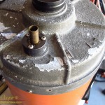
It looked horrible! The paint was coming off everywhere with heavily corroded aluminum underneath. Most of the screw heads were small balls of rust, with hopefully enough remaining to fit a screwdriver to and remove. For a precision optical instrument this small telescope was not very encouraging.
Looking at what remains of the paint on an old Celestron C8 orange tube telescopeOn the bright side the optics looked to be in decent shape. While there was some dirt and mold on the corrector, the primary looked almost perfect. Not bad considering the condition of the metal parts. Maybe, just maybe, this telescope is salvageable.
The telescope in question is an old orange tube Celestron C8. Thousands of these little telescopes were manufactured in the 70’s and 80’s. It was the C8 that set the standard for amateur telescopes at the time. The C8 is still in production forty years later, but the tubes are no longer painted orange as they were originally. Compact, yet offering decent performance, these telescopes were well regarded and hold a special place in the memories of many amateur astronomers. I have seen these little orange telescopes at dozens of star parties, even bolted to the side of huge professional telescopes for use as finders.
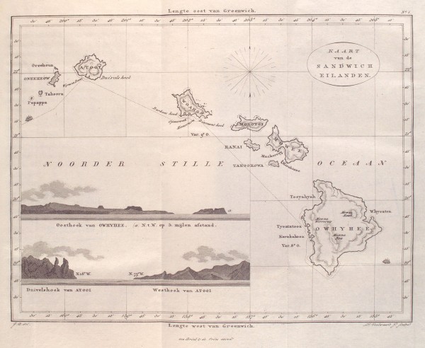
Among the items I found in the NYPL image collection was an 1835 map of the Hawaiian Islands. I included it in the posting on the collection, but the map truly deserves a closer look. It preserves the western view of the islands as of the early 19th century.
The map is reasonably accurate, looking at the coordinates given for key points in the islands shows that they are correctly plotted. The outlines of the islands are mostly familiar. The shapes of Molokai, Maui, and parts of Hawaiʻi do show some odd features that look odd to anyone with a good knowledge of local geography. Any number of points and bays seem exaggerated, note the peninsulas on the north shores of Oahu and Maui. Notably Kealakekua bay is drawn as much more sheltered than it really is, an odd inaccuracy in a maritime map.
Continuing inspection reveals a number of other oddities… There are two islands marked on the map south of Niʻihau, named Tahoora and Papappa. Modern navigation maps mark only one island here, Kaʻula. Tahoora (Kaʻula) was spotted by the Cook expedition and recorded with that name. Reference to Papappa can be found in the 1870 Seaman’s Guide to the Islands of the North Pacific, Part II, W. H. Rosser. Apparently local fisherman reported another island south of Kaʻula. A number of ships looked for such an island in vain. The guide lists its existence as “doubtful”.
Map of the Sandwich Islands (Hawai’i) issued in 1835 by Jacobus Boelen
It is also interesting to note that the coordinate system used is referenced to Greenwich. Thus the longitudes marked at the bottom match those found on modern maps. At the time the prime meridian, the location of zero longitude, was hotly contested between several possible locations. It was not until the 1884 International Meridian Conference that Greenwich became the accepted standard worldwide. This was over the objections of the French who abstained from the vote and continued to use the Paris meridian until 1911.
Of course it is the place names that are the most fascinating feature of the map. Setting aside the Dutch vocabulary and looking just at the transcriptions of the Hawaiian place names one sees familiar names as they were used two centuries ago.
Looking about the map one will note Owhyhee in place of the modern Hawaiʻi, Mowee and Woahoo as the old versions of Maui and Oaho, quite recognizable. If you have read the old accounts you may recognize Atooi as the island of Kauai. We also see Mowna Kaah printed on the map for present day Mauna Kea, similar to the Mauna Kaah found in the Cook expedition journals as the first written version of the mountain’s name.
Map Name
Current Name
Atooi
Kauai
Honoruru
Honolulu
Karakakooa
Kealakekua
Mowna Kaah
Mauna Kea
Mowna Worroray
Hualālai
Mowna Roa
Mauna Loa
Morokinne
Molokini
Morotoi
Molokai
Mowee
Maui
Oneeheow
Niʻihau
Oreehoua
Lehua
Owyhee
Hawai’i
Ranai
Lanai
Tahoora
Kaʻula
Tahoorowa
Kahoʻolawe
Woahoo
Oahu
Currently accepted place names compared to the names found on the 1835 map by Jacobus Boelen
The confirmation of gravitational waves is simply a huge moment for science. A lot of people have spent their lives building instruments in hope for this day. From one who maintains another great scientific instrument to those who built LIGO… Congratulations!!
Not to understate the magnitude of the achievement, this is a huge discovery, but as usual XKCD puts a fun spin on the moment…
The 1999 Total Solar Eclipse from France, image credit Luc ViatorThe path of totality passes well north of the Hawaiian Islands, just south of Midway Island. If you want to see this eclipse as a total your best bet is an eclipse cruise. For the islands this will be a deep partial eclipse, ranging from about 67% for Kauai and the around 55% for the Big Island. Of course, the exact amount of the Sun covered by the Moon will depend greatly on your location. See the table below for predictions and timing for your location.
Note, you might be confused by some references that state the eclipse occurs on March 9th. It does occur on the 9th! For our islands greatest eclipse occurs around 03:30 on March 9th universal time. If we convert to Hawaiian Standard Time this will be the 17:30 (5:30pm) on the afternoon of March 8th. You must remember that universal time is ten hours ahead of Hawaiian Standard Time.
Diagram of the March 9, 2016 Total Solar EclipseThere are several cruises scheduled to intercept this eclipse. Most look to observe the eclipse somewhere near Indonesia, where the eclipse will be at its maximum. This is where you will find the hardcore eclipse chasers, including a few island folks I know. Most of us will just have to settle for seeing this eclipse as a partial, including myself. The information presented here covers viewing the eclipse from the islands.
A deep partial can be very interesting. Even people not expecting the eclipse may notice a dimming of the Sun and an odd, subdued nature to the sunlight. Even a quick glimpse of the Sun will reveal that half of the disk is covered. Eclipse glasses or a welding filter will provide a nice image of a partially eclipsed Sun. Tree leaves and other makeshift pinhole cameras will show crescent images of the Sun on the ground. For best viewing a small telescope with a solar filter, or a pinhole camera will allow excellent images of the eclipse. My standard eclipse viewing setup is a 76mm refractor with a Baader film solar filter. I assembled this gear for the 2012 Venus transit and it has seen several eclipses since.
The table at the right gives the eclipse timing for a few locations across the Hawaiian Islands. All times are given in Hawaiian Standard Time, just remember that 17:36 is 5:36pm in 12 hour time, just subtract 12.
As you can see the magnitude of the eclipse increases notably the closer you are (further north in the main islands) to the path of totality. The timing does not vary by nearly as much, with maximum eclipse occurring around 17:36 for the islands.
If you would like to see precise information for your location, or for someplace other than the islands, just use the interactive map and click on your location for data.
A partial solar eclipse from Kawaihae, 9 May 2013Observing a partial solar eclipse requires proper eye protection. If you can not look safely, do not look! Even dimmed by 50% or more the Sun can cause permanent eye damage if viewed without proper protection. A solar filter is required for telescopic or binocular use. A good view can be had without magnification simply using a welding filter (shade 13 or darker) or solar viewing glasses to look directly at the Sun. A pinhole camera can be made out of things lying around in your kitchen that provides a very good image. Read my Guide to Safe Solar Viewing for a lot more information on viewing the Sun safely.
There are no further solar eclipses near the Hawaiian islands until 2031 and 2035, the path of totality for both of which pass well south of the main islands. There is also an annular eclipse in 2024, for which the center line also passes well south of the islands.
You have heard it before, but it really is true! Looking at the Sun for longer than a few brief moments with an unprotected eye can lead to permanent damage. Looking at the Sun with any sort of optical deceive that has not been properly filtered can lead to instantaneous eye damage.
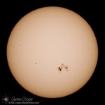
The complex sunspot AR2192 visible on 24 October, 2014
Discussed below are the only safe methods I am aware of to view the Sun. There are some dodgy methods out there. Take chance with your irreplaceable eyesight? I think not. Be careful and do it right if you want a look.
For the unaided eye there are a couple options to view the Sun safely…