A beautiful image from the NOAA-NASA GOES Project of a full disk Earth. Off to the west of the islands you can see the re-formed Hurricane Kilo, to our immediate east if Ignacio, with Jimena right behind. The forecast calls for tropical storm force winds to begin on the island as soon as tonight. Also visible is an active region of thunderstorms off the Mexican coast, the spawning ground for the next hurricane.
Click on the image for full glory!
Three Pacific hurricanes visible in this full disk weather image from the NOAA-NASA GOES Project
Almost the entire Keck Observatory staff forming the hexagonal outline of one of the primary mirrors. Seeing the size of one of the mirrors like this really puts things in scale.
Our director, Dr. Hilton Lewis, is center front. Do not look for me… I am standing on the ladder taking the photo.
Nearly the entire Keck staff forming the outline of one of the primary telescope mirrors
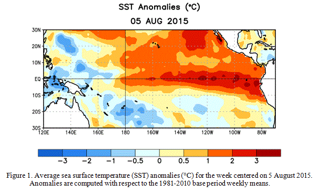
Officially referred to as ENSO, or El Niño Southern Ocsillation, this event is a period of dramatically warm surface water temperatures that occurs across the equatorial Pacific Ocean. These events usually alternate with periods of cooler temperatures, or La Niña events, and can have dramatic effects on weather across the globe.
The immediate effects of the warming water are already being felt… Water temperatures around the islands are at least 2°C above normal, pushing our normally cool water into near bathtub temperatures. Local divers are commenting on the warm water temperatures, those who normally wear wet suits are comfortable without.
This warm water is also fueling the series of hurricanes sweeping past the islands. The storms just keep coming. It will be an interesting year!
Sea surface temperature anomaly charts for August 2015
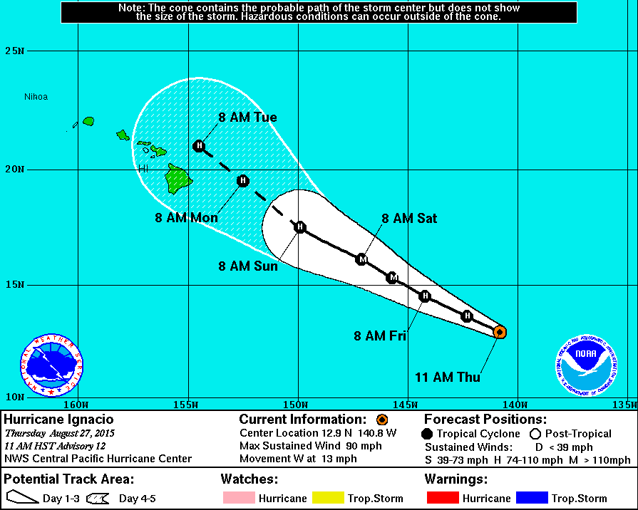
It looks like yet another hurricane is coming this way, the island squarely in the predicted path. The seemingly endless series of storms passing through is making the 2015 hurricane season one of the most active on record.
Ignacio is expected to become a major storm, crossing the island as a full hurricane. If that is not enough we have Jimena further out and following a similar track. No one expects that to be the end of the series either, with sea water temperatures well above normal and continuing to warm there will be further storms.
I am truly grateful we live on the leeward side of the island, sheltered from the worst of the effects of these storms. A 14,000ft mountain standing between our house and the oncoming hurricane. I do worry about our many friends who live on the other side of the island.
As the storm nears and if it becomes apparent that the island will be hit we will perform our last minute storm preparations, fill the water jugs and secure the lanai furniture. Everything else is already done, held over from the last storm, plenty of emergency supplies and propane on-hand.
The predicted path of Hurricane Ignacio as of 27 Aug 2015
The past two weeks have seen a great deal of precipitation over normally dry Kohala grasslands. Over three inches at the house last week and another three over the last few days from the remains of tropical storm Kilo. This amounts to over half our normal annual rainfall for Waikoloa. The result has been hot muggy weather that has everyone complaining.
No sign of it letting up either. Tropical depression 12E has graduated into tropical storm Ignacio with a probable path that includes the island. Looking at the sea temperature anomaly maps gives a possible reason, the forming El Nino is stronger than expected, surprisingly warm. Life will be interesting.
Our rain gauge showing over three inches from tropical storm Kilo
Is it bad when you can fill an entire washer load with only aloha shirts?
Yes, we really wear Hawaiian shirts here in Hawaiʻi. Or, as they are called locally, aloha shirts. I remember my first week on the job. I was wearing a modestly colorful shirt in the office and I was wondering if it was appropriate. As I looked about the meeting I noted that two thirds of those present were wearing the colorful shirts, including my supervisor and department head. Yeah, need to buy more.
The bright planet Venus will appear in the dawn sky over the next couple weeks, climbing higher to become the morning star for the remainder of 2015. It is currently 15° from the Sun and shining at magnitude -4.2, bright enough to be seen against the dawn sky. It will reach maximum elongation on October 26th, 46° above the rising Sun.
It is bad… A wildfire burns a few thousand acres. Follow that up with torrential rains to sweep all of the ash and mud onto the reef. There is a reason we are not diving this weekend. We had planned to, the water needs a week to clear out the murk. It will be interesting to see the impact on the reef.