Death by Salt

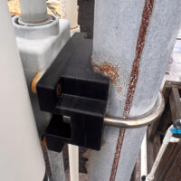
Conditions at work can be rough…

Severe corrosion of a printed circuit with exposure to shoreline conditions

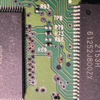
The printed circuit board in the photograph here came from an industrial label printer, one used to create labels for our product packages. The printer refused to print for no apparent reason, and despite numerous attempts to update or replace printer drivers, using a different computer, and other fiddling it remained stubbornly inoperative.

So we bought a replacemnt and continued shipping product.

The printer sat in my office for a bit, and one quiet afternoon I decided to do a little forensic disassembly, and scrap any useful bits before I tossed the remaing carcass.

Continue reading “Death by Salt”

An ABS 3D Print in the Sun

The screws are rusted, the brass inserts darkend with exposure to salt and rain, the post it is clamped to is likewise suffering from corrosion in the salt air, but the 3D print is just fine.

An ABS 3D print that has spent four years in intense tropical sunlight.

Some plastics used for 3D printing decay fairly rapidly with exposure to sunlight and weather. Certianly PLA, the most common 3D plastic, crumbles to dust in just a year of harsh weathering. ABS or Acrylonitrile Butadiene Styrene on the other hand, seems to perform quite well.

Working at Symbrosia I have created dozens upon dozens of designs, many of which are installed in the extremely harsh environment of our outdoor cultivation area. Here the prints sit in intense tropical Hawaiian sunlight for days on end, subject to both intense UV light and high temperatures. The plastic is also subject to continual exposure to salt water used in our operation, or raining from the sky on days with heavy surf, when the waves are crashing just 100 yards away. It does not get much worse than this.

Continue reading “An ABS 3D Print in the Sun”

Yet Another Hurricane

It has been a wet weekend here as yet another hurricane makes a swipe at the island.

This has meant over an inch of rain and some strong winds at the house. A pair of 14,000ft mauna between us and the oncoming storms has worked as usual.

The windward side took the brunt of the storm, but this was a marginal hurricane. In general there have been no major impacts on the island beyond some localized flooding in the usual places and downed trees blocking roads.

I did deploy a new rain gauge this weekend, just in time for the deluge. An electronic tipping bucket of my own design that seems to be operating quite nicely.

Hurricane Hone passing south of the islands bringing wind and heavy rain the the Island of Hawaii on August 25, 2024

SO2 Monitoring Station

Living with active volcanoes about becomes a bit easier if they are properly monitored. The entire island of Hawai‘i is liberally equipped with sensors of various types… Seismographs, tiltmeters, GPS stations, cameras, and gas monitors.

Weather and SO2 monitoring station
A remote weather and SO2 monitoring station

I came across one of these last instruments on a recent visit to Hawai‘i Volcanoes National Park, the new Kahuku Unit at the south end of the island. While walking in the gorgeous natural scenery of the park, this engineer was instantly attracted to a spindly frame of tubes standing in an old corral.

The Kahuku Cross Fence station is part of the NPS maintained Hawaii SO2 Network with stations throughout the park. The data is provided to rangers and posted on the park website to advise visitors of volcanic gas hazards while visiting the volcanoes.

Continue reading “SO2 Monitoring Station”

A Hole-Punch Cloud

We were just setting up the telescopes when I looked up and spotted it.

Waikoloa School was hosting a community picnic, a couple bands, food, performances by a karate club and a halau, plus a few telescopes provided by Keck and the West Hawaii Astronomy Club. It promised to be a fun evening.

What I spotted was a hole-punch cloud above the school. OK, that was unexpected. A high thin layer of altocumulus perforated by a neat circular hole.

The hole had a thickened edge as if something had pushed the cloud layer aside. Otherwise it was completely clear in the center and nearly perfectly circular.

Hole punch clouds are often formed when something passes through a cloud layer, such as an aircraft, disturbing and destabilizing it. This does not appear to be the case here, rather I would guess that an updraft from below pushed its way into this particular cloud from below.

The hole was short lived, fading in about 15-20 minutes as the cloud layer reformed.

A Hole-Punch Cloud over Waikoloa
A Hole-Punch Cloud over Waikoloa School

Kelvin-Helmholtz Waves

When two bodies of fluid are moving in different directions interesting things happen at the boundary. The result is usually some sort of wave… Waves on the surface of the ocean or waves in the sky.

Waves on the sea surface are easy to see. Waves in the sky? Not so much. These waves are only betrayed if clouds form in the waves, revealing these structures.

Kelvin-Helmholtz Waves in the Saddle
Kelvin-Helmholtz Waves in the Saddle with Mauna Loa in the background. Photo by Joe Gargiulo, used with permission
This sort of wave is called a Kelvin-Helmholtz wave after Lord Kelvin and Hermann von Helmholtz who first investigated how these waves form. Yes this is the same Kelvin for whom the units of temperature are named. KH waves are visible all around us for those who know to look, from the surface of our ocean to the clouds of Jupiter, these characteristic swirling patterns are seen.

In the Saddle region over Mauna Kea and Mauna Loa, there are usually two air masses moving in different directions. Below the inversion level the tradewinds push westward. While above the inversion level, usually about 6-7,000ft, the upper air moves to the east. Where these two meet there are often KH waves, and occasionally some clouds to outline these fascinating structures.

Madeline Arrives

So far is is just windy.

As the first part of the storm pushes ashore on the other side of the island all we are getting is wind. Gusty conditions prevail from Waimea to Waikoloa, about what we would get on a bad day of trade winds. It is enough to bump your car around the road a bit, with gusts around 45mph.

Keck closed up HQ at noon today, sending everyone home. Observing was cancelled last night and is cancelled again tonight. A few support guys went to the summit this morning, checked everything, then left.

While Madeline has been downgraded to a tropical storm, Lester remains a strong hurricane. I am a little more worried about the weather Lester will bring on Saturday.

Hurricane Afternoon
The view from Waimea towards Mauna Kea as Madeline pushes ashore. The cloud bands are just visible as the high clouds on the left.

A Few Storms

A beautiful image from the NOAA-NASA GOES Project of a full disk Earth. Off to the west of the islands you can see the re-formed Hurricane Kilo, to our immediate east if Ignacio, with Jimena right behind. The forecast calls for tropical storm force winds to begin on the island as soon as tonight. Also visible is an active region of thunderstorms off the Mexican coast, the spawning ground for the next hurricane.

Click on the image for full glory!

Three Pacific hurricanes visible in this full disk weather image from the NOAA-NASA GOES Project

The 2015 El Niño Event

The intensifying El Niño event in the Pacific is looking to be the strongest event of the last 50 years. Some news outlets have dubbed it the “Godzilla” El Niño.

Officially referred to as ENSO, or El Niño Southern Ocsillation, this event is a period of dramatically warm surface water temperatures that occurs across the equatorial Pacific Ocean. These events usually alternate with periods of cooler temperatures, or La Niña events, and can have dramatic effects on weather across the globe.

The immediate effects of the warming water are already being felt… Water temperatures around the islands are at least 2°C above normal, pushing our normally cool water into near bathtub temperatures. Local divers are commenting on the warm water temperatures, those who normally wear wet suits are comfortable without.

This warm water is also fueling the series of hurricanes sweeping past the islands. The storms just keep coming. It will be an interesting year!

Sea Surface Temperature Anomaly
Sea surface temperature anomaly charts for August 2015