The past two weeks have seen a great deal of precipitation over normally dry Kohala grasslands. Over three inches at the house last week and another three over the last few days from the remains of tropical storm Kilo. This amounts to over half our normal annual rainfall for Waikoloa. The result has been hot muggy weather that has everyone complaining.
No sign of it letting up either. Tropical depression 12E has graduated into tropical storm Ignacio with a probable path that includes the island. Looking at the sea temperature anomaly maps gives a possible reason, the forming El Nino is stronger than expected, surprisingly warm. Life will be interesting.
Our rain gauge showing over three inches from tropical storm Kilo
Previous forecasts showed the hurricane passing well north of the island, following the same track as the last two storms. Then this evening’s forecast came out.
The storm appears to be waning now, the satellite shows that much of it has passed the island. Not long ago the snowplow crews let it be known that they would not reach the summit today, try again tomorrow as the storm abates.
I did a bit of a photo survey of the summit using MastCam to check on the summit conditions. Poliʻahu rules Mauna Kea!
Looking at the summit ridge from the Keck after the storm
The IRTF coated with heavy ice
Looking at the summit ridge from the Keck after the storm
A ladder platform of the Keck 2 dome with a heavy coating of ice
Looking at the summit ridge from the Keck after the storm
UH88 under a heavy coating of ice after the storm
UKIRT under a heavy coating of ice after the storm
Keck 2 dome with a heavy coating of ice
A MastCam image of the snowdrifts covering the road between Keck and IRTF
The storm that deposited a heavy layer of ice on Mauna Kea has kept Keck Observatory shuttered for a week now. The last night we observed was New Year’s Day. Despite clear skies, there was just too much ice on the domes that could come crashing in on the telescope if we attempted to open. For a few days the Keck II dome was frozen in place by a pile of solid ice against the lower skirt.
We just got word that day crew, with a little solar help, has cleared the worst of the ice from the domes and we will be observing tonight.
Ice on the Keck 2 dome ladders after the New Year’s storm of 2015
The normally bland face of Uranus has become increasingly stormy, with enormous cloud systems so bright that for the first time ever, amateur astronomers are able to see details in the planet’s hazy blue-green atmosphere.
“The weather on Uranus is incredibly active,” said Imke de Pater, professor and chair of astronomy at the University of California, Berkeley, and leader of the team that first noticed the activity when observing the planet with adaptive optics on the W. M. Keck Observatory in Hawaii.
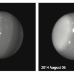
Infrared images of Uranus (1.6 and 2.2 microns) obtained on Aug. 6, 2014, with adaptive optics on the 10-meter Keck II telescope. Credit: Imke De Pater (UC Berkeley) & W. M. Keck Observatory“This type of activity would have been expected in 2007, when Uranus’s once every 42-year equinox occurred and the sun shined directly on the equator,” noted co-investigator Heidi Hammel of the Association of Universities for Research in Astronomy. “But we predicted that such activity would have died down by now. Why we see these incredible storms now is beyond anybody’s guess.”
In all, de Pater, Hammel and their team detected eight large storms on Uranus’s northern hemisphere when observing the planet with the Keck Observatory on August 5 and 6. One was the brightest storm ever seen on Uranus at 2.2 microns, a wavelength that senses clouds just below the tropopause, where the pressure ranges from about 300 to 500 mbar, or half the pressure at Earth’s surface. The storm accounted for 30 percent of all light reflected by the rest of the planet at this wavelength.
When amateur astronomers heard about the activity, they turned their telescopes on the planet and were amazed to see a bright blotch on the surface of a normally boring blue dot.
‘I got it!’
French amateur astronomer Marc Delcroix processed the amateur images and confirmed the discovery of a bright spot on an image by French amateur Régis De-Bénedictis, then in others taken by fellow amateurs in September and October. He had his own chance on Oct. 3 and 4 to photograph it with the Pic du Midi one-meter telescope, where on the second night, “I caught the feature when it was transiting, and I thought, ‘Yes, I got it!’” said Delcroix.
Hurricane Ana brought nothing more than a day of soaking rain to our part of the island. It was the lack of wind that was striking, with the hurricane directly offshore we had calm conditions. There was some flooding and moderate winds along the Kaʻu coast. Not much word on damage, I suspect it was minimal, nothing like what would have happened if the storm had followed the original forecast track.
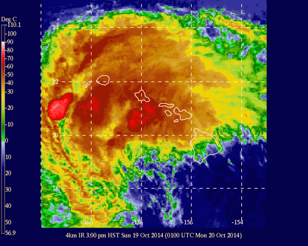
A new week has begin, time to see what next adventure life will bring…
Hurricane Ana as it appeared at 3pm 16Oct2014, 4km IR image from GEOS-West
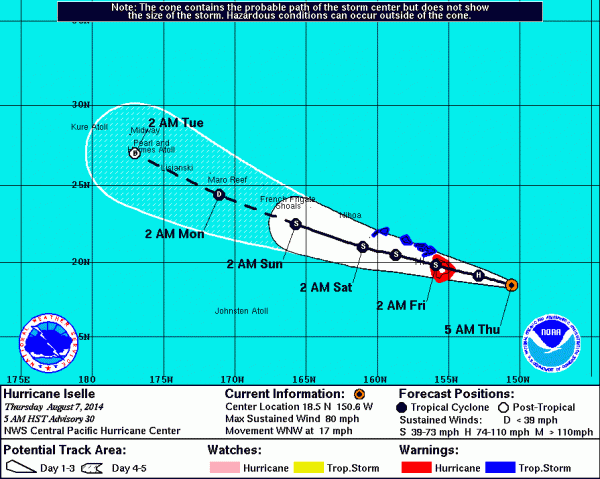
The island is still dealing with the damage wrought by Iselle. The Puna area took much of the damage with power lines down, fallen trees blocking many of the roads and damage to many houses. Fortunately there have been no reports of any deaths due to the storm. There are still thousands of residents without power as utility crews struggle to deal with the mess.
Residents on the west side saw few or no issues from the storm. We had almost no wind and just a little rain. Our precautions were totally unneeded, I guess we will use the water jugs to water the plants out front. Need to put the lanai furniture and barbeque back as well.
Despite our precautions Keck observatory has had issues due to the storm. Several systems suffered damage due to power line disruptions. We lost a motor controller in the K1 dome, I spent all of Saturday helping to replace that. Just as we were finishing repairing the dome the main breaker for the facility failed, leaving us on generator power. Waiting for word from the crew on restoring power. Until it is repaired we are off-sky. Update: Our intrepid day crew has fixed it. Yes, they are that good.
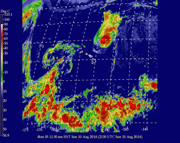
Hurricane Julio has spared the islands completely, tracking well north, far enough that we are clear of its effects. The storm is generating a big northeast swell that has the surfers looking for waves.
GEOS West 4km IR of hurricane Julio passing north of the islands, the remains of Iselle are seen west of Kauai
Dawn has come with an eerie silence, not a breath of wind. Yesterday afternoon and well into the night the winds ran hard, this morning there is calm. We received no measurable rain, while friends are posting views of Hilo rivers brown and raging. Obviously our internet is still moving bits and the lights still come on when you toggle the switch. The power flickered many times, but did not fail.
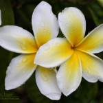
Plumeria (Plumeria obtusa) blossoms on the front lanaiI stand on a lanai stripped of furniture and barbecue grill to smell the plumeria blossoms. The last days seem surreal. The cool quiet broken only by the calling birds of the neighborhood. A scent calls me back inside, Deb is cooking dutch pancakes, a treat to celebrate the morning after the hurricane.
The storm is still here, dropping heavy rains on the south end of the island. Later this morning I will join the summit crew for a late departure to the summit and a quick check of the facility. Fill the instruments with cryogens, do a walk around, and not much more.
Hurricane Julio is still forecast to swing north of the island, sparing us the heavy rains and winds, though we may still feel some effect. It will move past the island on Sunday, as we cast wary eyes on the forecast charts. The coming week will bring a return to normalcy and the frantic activities of segment exchange.
Weather on any planet can be quite unpredictable. As hurricanes threaten the Aloha State, astronomers working at W. M. Keck Observatory on the island of Hawaii were surprised by the appearance of gigantic swirling storm systems on the distant planet Uranus.
Massive storms on Uranus captured August 5 and 6, 2014 as seen by Keck Observatory. Credit Imke de Pater (UC Berkeley)/Keck ObservatoryDuring the Voyager encounter with Uranus in 1986, only a scant handful of dim clouds were seen in its atmosphere. When the planet approached equinox in 2007 (i.e., when the Sun stood high above its equator), large storms developed on the planet, yet most of these faded.
In the past few days, however, astronomers were surprised by a multitude of bright storms on the planet, including one monstrous feature.
“We are always anxious to see that first image of the night of any planet or satellite, as we never know what it might have in store for us,” said Imke de Pater, professor at UC Berkeley and team leader. “This extremely bright feature we saw on UT 6 August 2014 reminds me of a similarly bright storm we saw on Uranus’s southern hemisphere during the years leading up to and at equinox”.
Now at the summit doing a last walk through the facility to insure everything is ready for the storm. A lot of the gear has been turned off to preserve the battery and generator capacity, keeping the network and the key servers operational so we can monitor remotely once everyone leaves.
The winds are picking up, some 60mph gusts along the summit ridge, a little less where Keck sits on the western side. Looking to the east we can see some cloud features that might be the front wall of the oncoming storm.
We plan to depart the summit in another hour and head for home. I expect the drive down to be as clear as the drive up, mostly clear with wild cloud formations over the summits.