Living with active volcanoes about becomes a bit easier if they are properly monitored. The entire island of Hawai‘i is liberally equipped with sensors of various types… Seismographs, tiltmeters, GPS stations, cameras, and gas monitors.
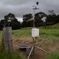
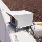
A remote weather and SO2 monitoring station
I came across one of these last instruments on a recent visit to Hawai‘i Volcanoes National Park, the new Kahuku Unit at the south end of the island. While walking in the gorgeous natural scenery of the park, this engineer was instantly attracted to a spindly frame of tubes standing in an old corral.
The Kahuku Cross Fence station is part of the NPS maintained Hawaii SO2 Network with stations throughout the park. The data is provided to rangers and posted on the park website to advise visitors of volcanic gas hazards while visiting the volcanoes.
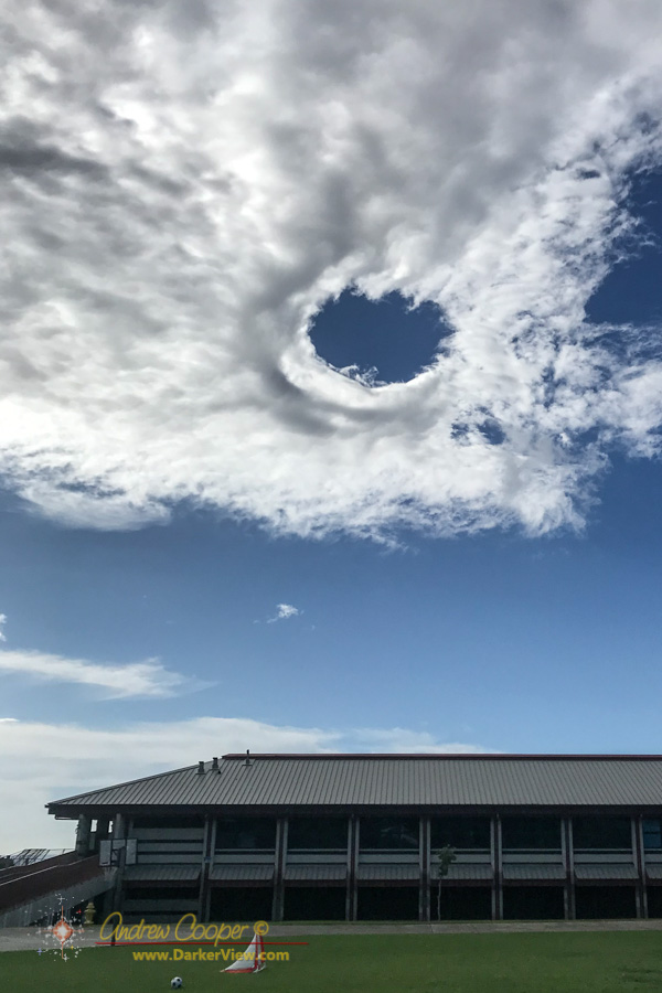
We were just setting up the telescopes when I looked up and spotted it.
Waikoloa School was hosting a community picnic, a couple bands, food, performances by a karate club and a halau, plus a few telescopes provided by Keck and the West Hawaii Astronomy Club. It promised to be a fun evening.
What I spotted was a hole-punch cloud above the school. OK, that was unexpected. A high thin layer of altocumulus perforated by a neat circular hole.
The hole had a thickened edge as if something had pushed the cloud layer aside. Otherwise it was completely clear in the center and nearly perfectly circular.
Hole punch clouds are often formed when something passes through a cloud layer, such as an aircraft, disturbing and destabilizing it. This does not appear to be the case here, rather I would guess that an updraft from below pushed its way into this particular cloud from below.
The hole was short lived, fading in about 15-20 minutes as the cloud layer reformed.
When two bodies of fluid are moving in different directions interesting things happen at the boundary. The result is usually some sort of wave… Waves on the surface of the ocean or waves in the sky.
Waves on the sea surface are easy to see. Waves in the sky? Not so much. These waves are only betrayed if clouds form in the waves, revealing these structures.
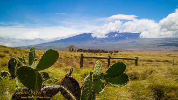
Kelvin-Helmholtz Waves in the Saddle with Mauna Loa in the background. Photo by Joe Gargiulo, used with permissionThis sort of wave is called a Kelvin-Helmholtz wave after Lord Kelvin and Hermann von Helmholtz who first investigated how these waves form. Yes this is the same Kelvin for whom the units of temperature are named. KH waves are visible all around us for those who know to look, from the surface of our ocean to the clouds of Jupiter, these characteristic swirling patterns are seen.
In the Saddle region over Mauna Kea and Mauna Loa, there are usually two air masses moving in different directions. Below the inversion level the tradewinds push westward. While above the inversion level, usually about 6-7,000ft, the upper air moves to the east. Where these two meet there are often KH waves, and occasionally some clouds to outline these fascinating structures.
As the first part of the storm pushes ashore on the other side of the island all we are getting is wind. Gusty conditions prevail from Waimea to Waikoloa, about what we would get on a bad day of trade winds. It is enough to bump your car around the road a bit, with gusts around 45mph.
Keck closed up HQ at noon today, sending everyone home. Observing was cancelled last night and is cancelled again tonight. A few support guys went to the summit this morning, checked everything, then left.
While Madeline has been downgraded to a tropical storm, Lester remains a strong hurricane. I am a little more worried about the weather Lester will bring on Saturday.
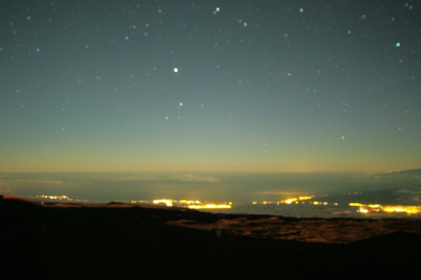
The view from Waimea towards Mauna Kea as Madeline pushes ashore. The cloud bands are just visible as the high clouds on the left.
A beautiful image from the NOAA-NASA GOES Project of a full disk Earth. Off to the west of the islands you can see the re-formed Hurricane Kilo, to our immediate east if Ignacio, with Jimena right behind. The forecast calls for tropical storm force winds to begin on the island as soon as tonight. Also visible is an active region of thunderstorms off the Mexican coast, the spawning ground for the next hurricane.
Click on the image for full glory!
Three Pacific hurricanes visible in this full disk weather image from the NOAA-NASA GOES Project
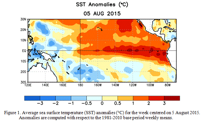
Officially referred to as ENSO, or El Niño Southern Ocsillation, this event is a period of dramatically warm surface water temperatures that occurs across the equatorial Pacific Ocean. These events usually alternate with periods of cooler temperatures, or La Niña events, and can have dramatic effects on weather across the globe.
The immediate effects of the warming water are already being felt… Water temperatures around the islands are at least 2°C above normal, pushing our normally cool water into near bathtub temperatures. Local divers are commenting on the warm water temperatures, those who normally wear wet suits are comfortable without.
This warm water is also fueling the series of hurricanes sweeping past the islands. The storms just keep coming. It will be an interesting year!
Sea surface temperature anomaly charts for August 2015
National Weather Service watch map for 22Dec2014.Yes, it can happen… The local NWS office has issued a blizzard watch for the summits of Mauna Kea and Mauna Loa.
It will be interesting to see just how much snow we do get. The Mauna Kea Weather Center is predicting a possible six inches. I do not plan on being on the summit until Friday. A white Christmas?
It works! We now have a CloudCam at Keck. It is not quite ready for full active service, but it is alive and taking images. I got the network connection running yesterday, after mounting the camera and running the various cables over the last couple weeks. A little time for commissioning and getting the software setup and the camera will be available to everyone.
The housing for the Keck CloudCam ready for the worst in Mauna Kea weather.
Our camera was built by Kanoa over at the Canada France Hawaii Telescope. Kanoa built the first CloudCam that has served CFHT so well. In service for a couple years now, the CFHT CloudCam gives our telescope operators an unparalleled view of the weather. This is critically important as heavy fog, rain or snow can damage the telescope optical coatings.
To secure and protect the enclosure Kanoa built I fabricated a solid mount. A heavy machined plate and an aluminum cover should shield the camera from the worst that Mauna Kea Weather can dish out. The camera electronics warm the box nicely and a heater is installed to warm and deice the window. We shall see how it fares, the summit weather can be amazing.
With the original CloudCam pointing east, over Hilo, our CloudCam points west, a complementary view of the weather approaching the summit from either direction. The imagery will be closely monitored by all of the telescope operators on the summit during marginal weather.
The imagery will be available to the public as well. Expect live images as well as compiled movies of each night. The first CloudCam has quite a following, quite a few people check the camera constantly. This includes quite a few UFO consipracists. If anything odd shows up on the camera the video quickly shows up on YouTube and linked to postings on the UFO sites.
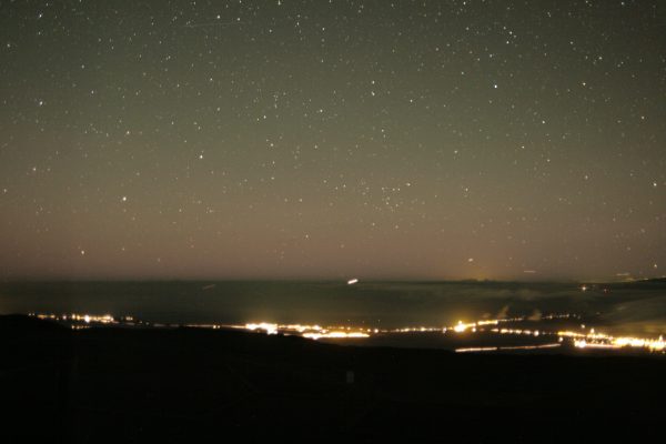
Yes, the focus needs to be adjusted (I expected that), but the scene covers a nice range from the Waikoloa resorts on the left, past Kawaihae, to Waimea on the right.
A test image from the Keck CloudCam
And after focus adjustment we get much nicer stars…
A CloudCam image showing the lights of Waikoloa, Waimea, and a lot of evening inter-island air traffic.
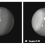
Weather on any planet can be quite unpredictable. As hurricanes threaten the Aloha State, astronomers working at W. M. Keck Observatory on the island of Hawaii were surprised by the appearance of gigantic swirling storm systems on the distant planet Uranus.
Massive storms on Uranus captured August 5 and 6, 2014 as seen by Keck Observatory. Credit Imke de Pater (UC Berkeley)/Keck ObservatoryDuring the Voyager encounter with Uranus in 1986, only a scant handful of dim clouds were seen in its atmosphere. When the planet approached equinox in 2007 (i.e., when the Sun stood high above its equator), large storms developed on the planet, yet most of these faded.
In the past few days, however, astronomers were surprised by a multitude of bright storms on the planet, including one monstrous feature.
“We are always anxious to see that first image of the night of any planet or satellite, as we never know what it might have in store for us,” said Imke de Pater, professor at UC Berkeley and team leader. “This extremely bright feature we saw on UT 6 August 2014 reminds me of a similarly bright storm we saw on Uranus’s southern hemisphere during the years leading up to and at equinox”.