A Still-Growing El Niño Set to Bear Down on US

JPL press release

The current strong El Niño brewing in the Pacific Ocean shows no signs of waning, as seen in the latest satellite image from the U.S./European Ocean Surface Topography Mission (OSTM)/Jason-2 mission.

El Nino 2015
The latest satellite image of Pacific sea surface heights compared with 1997. Credit: NASA/JPL-Caltech
El Niño 2015 has already created weather chaos around the world. Over the next few months, forecasters expect the United States to feel its impacts as well.

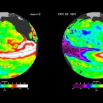
The latest Jason-2 image bears a striking resemblance to one from December 1997, by Jason-2’s predecessor, the NASA/Centre National d’Etudes Spatiales (CNES) Topex/Poseidon mission, during the last large El Niño event. Both reflect the classic pattern of a fully developed El Niño. The images can be viewed at: http://sealevel.jpl.nasa.gov/elnino2015/index.html

The images show nearly identical, unusually high sea surface heights along the equator in the central and eastern Pacific: the signature of a big and powerful El Niño. Higher-than-normal sea surface heights are an indication that a thick layer of warm water is present.

Continue reading “A Still-Growing El Niño Set to Bear Down on US”

The 2015 El Niño Event

The intensifying El Niño event in the Pacific is looking to be the strongest event of the last 50 years. Some news outlets have dubbed it the “Godzilla” El Niño.

Officially referred to as ENSO, or El Niño Southern Ocsillation, this event is a period of dramatically warm surface water temperatures that occurs across the equatorial Pacific Ocean. These events usually alternate with periods of cooler temperatures, or La Niña events, and can have dramatic effects on weather across the globe.

The immediate effects of the warming water are already being felt… Water temperatures around the islands are at least 2°C above normal, pushing our normally cool water into near bathtub temperatures. Local divers are commenting on the warm water temperatures, those who normally wear wet suits are comfortable without.

This warm water is also fueling the series of hurricanes sweeping past the islands. The storms just keep coming. It will be an interesting year!

Sea Surface Temperature Anomaly
Sea surface temperature anomaly charts for August 2015