A Still-Growing El Niño Set to Bear Down on US

JPL press release

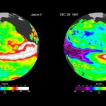
The current strong El Niño brewing in the Pacific Ocean shows no signs of waning, as seen in the latest satellite image from the U.S./European Ocean Surface Topography Mission (OSTM)/Jason-2 mission.
El Nino 2015
The latest satellite image of Pacific sea surface heights compared with 1997. Credit: NASA/JPL-Caltech
El Niño 2015 has already created weather chaos around the world. Over the next few months, forecasters expect the United States to feel its impacts as well.

The latest Jason-2 image bears a striking resemblance to one from December 1997, by Jason-2’s predecessor, the NASA/Centre National d’Etudes Spatiales (CNES) Topex/Poseidon mission, during the last large El Niño event. Both reflect the classic pattern of a fully developed El Niño. The images can be viewed at: http://sealevel.jpl.nasa.gov/elnino2015/index.html

The images show nearly identical, unusually high sea surface heights along the equator in the central and eastern Pacific: the signature of a big and powerful El Niño. Higher-than-normal sea surface heights are an indication that a thick layer of warm water is present.

Continue reading “A Still-Growing El Niño Set to Bear Down on US”

A Few Storms

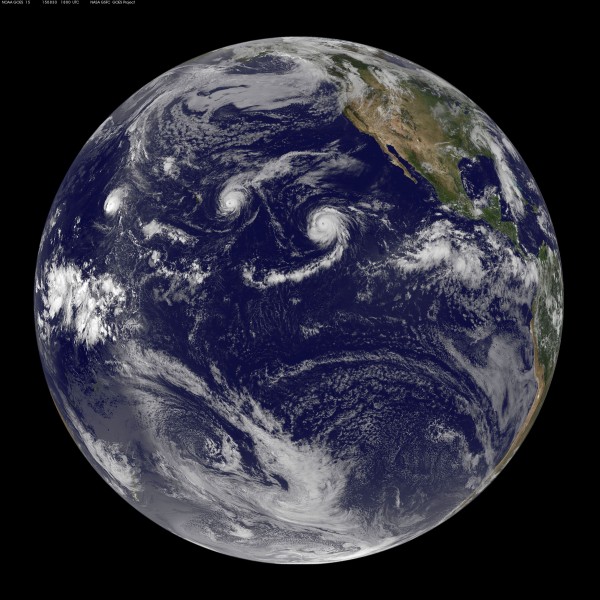
A beautiful image from the NOAA-NASA GOES Project of a full disk Earth. Off to the west of the islands you can see the re-formed Hurricane Kilo, to our immediate east if Ignacio, with Jimena right behind. The forecast calls for tropical storm force winds to begin on the island as soon as tonight. Also visible is an active region of thunderstorms off the Mexican coast, the spawning ground for the next hurricane.

Click on the image for full glory!

Three Pacific hurricanes visible in this full disk weather image from the NOAA-NASA GOES Project

Jumping the Pond

I normally get on an airplane about once or twice a year. This summer that will be three trips in two months, with just a few weeks in-between. Two of those hops will be back and forth to the mainland, a five hour flight from the islands.

Over the Pacific
34,000ft over the Pacific Ocean
I am on the first leg of the last trip as I write this, the third jump across the pond in as many weeks. The first destination is Seattle and a family reunion to celebrate my parent’s 50th wedding anniversary. Then it is off to Alaska to do some fishing and bring the boat down the coast to the Puget Sound for the winter.

As I look down on the expanse of blue water my mind wanders. Perhaps the upcoming boating expedition has lent a nautical meme to my thoughts… I think of those who sailed into that blue with no idea of what lay ahead. The explorers who set course into the vast Pacific not knowing if they would find a reef the hard way in the night.

I consider the ancient Polynesians who chose a course without a compass or chart, navigating by the stars and waves. Their journeys would last for weeks or months, possibly much longer if the winds did not cooperate. Using hard earned knwolege they would locate the tiny specks of land scattered acrooss this vast expanse of blue.

Here I sit in relative comfort. Perhaps a bit confined, a small seat amoung many others, but I need endure for only a few hours. I sit at the window and watch the small clouds slide by below, trying not to look at the clock. One can look at the map, but somehow fails to convey the reality of that seemingly endless blue outside my window. I imagine a double hulled canoe, with coconut sails, upon those waves 34,000ft below.