First Storm of the Season

Here we go again.

Hurricane Douglas approaches the islands, GEOS West infrared image at noon, 25 July, 2020

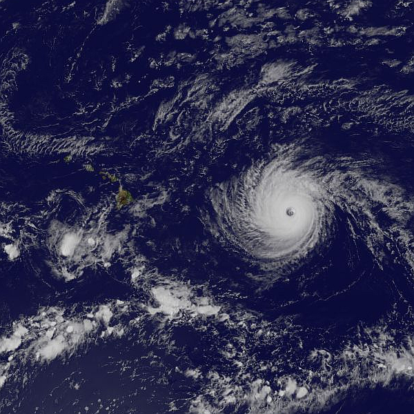
Hurricane Douglas is the first hurricane to threaten the islands this season. The storm was a strong category 3 but has weakened a bit. It still packs 100mph winds and is expected to remain a hurricane as it passes.

Fortunately the path has shifted to the north slightly over the last 24 hours. The storm is now expected to miss the islands by a bit. Not by much, but enough to avoid hurricane force winds making landfall.

What we do expect is tropical storm force winds and heavy rain. We are ready for the winds, I secured everything yesterday. The rain? We could use some rain. The best outcome would be a day of good soaking rains on our side of the island.

Hurricane Lane Passes By

Weather? Currently overcast, no rain, and almost no breeze. Hard to believe there is a hurricane just offshore.

The worst wind was early last night, and then no worse than a strong trade wind event. We have had much worse several times this year.

The rain gauge has not even made it to an inch of precipitation. We have had none of the torrential rain the other side of the island has experienced.

All is quiet here, no damage beyond having to pick up the usual scattered palm fronds.

The video below is the storm passing by our island over the last 38 hours. I started saving the 4km IR images as soon as the eye of Hurricane Lane entered the close range image and have assembled them into a video.

This is our closest pass so far for a hurricane. May the remainder of the season be uneventful…

Here we go again…

Maybe a little closer to us this time.

Hurricane Lane is looking to swing north just east of the island. The worst of the storm should pass through tomorrow. All of our Keck staff has been told to stay home and take care of family and property, observing is cancelled for the next two nights.

Hurricane Lane approaches the islands as seen in this 4km resolution IR image

Hector Brushes Past

Hurricane Hector is just brushing past us with the center of the storm well south of the island. At this point the tropical storm watch and warnings have been cancelled. The only real effect on the island is some rain and high surf along the south shore.

Outside the weather is blustery and raining, but that could just be normal Waimea weather. At least it looks and feels a bit like a hurricane.

Hurricane Hector brushing past the islands as seen from GEOS-West on Aug 8th, 2018

Eruptions, Earthquakes, Wildfires, and now a Hurricane

Can we keep our natural disasters to one-at-a-time?

A large wildfire burning above Waikoloa Village
This is getting to be just a bit much. We have an ongoing eruption on Kilauea that is larger than anything the volcano has put forth in centuries.

As a result of the eruption we are experiencing daily earthquakes of mag three to five. Not counting the hundreds of first and second magnitude earthquakes each day. The eruption also brings serious air quality issues, cracking highways, and more

There is currently a large brush fire burning above Waikoloa Village and roads remain closed for a second day. Like most village residents we spent a nervous night wondering if the high winds would allow the fire to jump the firebreaks.

And to top it all off we now have Hurricane Hector bearing on a direct course for the island.

Just what is next? A plague of frogs? Oh yeah, we have that too.

Hurricane Week is Over

Well? We have survived Hurricane Week, two hurricanes brushing past the island. Other than a bit of rain and shattered schedules we are just fine. Madeline caused some power outages and dumped a good deal of rain on the windward side. Lester turned north and did not impact the island to any significant degree other than high surf.

Here in Waikoloa we got some wind and no rain from Madeline, and a touch of rain from the water vapor left behind by Lester. Mostly it has just been muggy and hot here on the leeward side.

Plumeria
A photo of our plumeria processed by Prisma

Next Up? Hurricane Lester

Hurricane Madeline has come and gone. Other than some flooding, a few power outages, and minor damage here and there, Madeline failed to leave much of an impact on the Big Island. Indeed, satellite imagery loops show the storm coming apart as it interacted with the island and the big mauna. At the house there was some wind, no rain, just a very warm and muggy afternoon and night.

Next up is Hurricane Lester, due to brush the northern side of the island on Saturday…

GOES West 20160901
Hurricane Lester approaching the Hawaiian Islands on September 1, 2016. GOES West color image.

Madeline Arrives

So far is is just windy.

As the first part of the storm pushes ashore on the other side of the island all we are getting is wind. Gusty conditions prevail from Waimea to Waikoloa, about what we would get on a bad day of trade winds. It is enough to bump your car around the road a bit, with gusts around 45mph.

Keck closed up HQ at noon today, sending everyone home. Observing was cancelled last night and is cancelled again tonight. A few support guys went to the summit this morning, checked everything, then left.

While Madeline has been downgraded to a tropical storm, Lester remains a strong hurricane. I am a little more worried about the weather Lester will bring on Saturday.

Hurricane Afternoon
The view from Waimea towards Mauna Kea as Madeline pushes ashore. The cloud bands are just visible as the high clouds on the left.