So… I assembled something from all of the video I took at Falls Creek Falls and Panther Falls. A small taste of a waterfall hike in the forests of Southern Washington.
Two goals… Get out and enjoy a proper PNW forest hike. Yes, we have waterfalls in Hawaii, just not quite the same. Second… Take a pile of photos and video. I do enjoy a day set aside for photography.
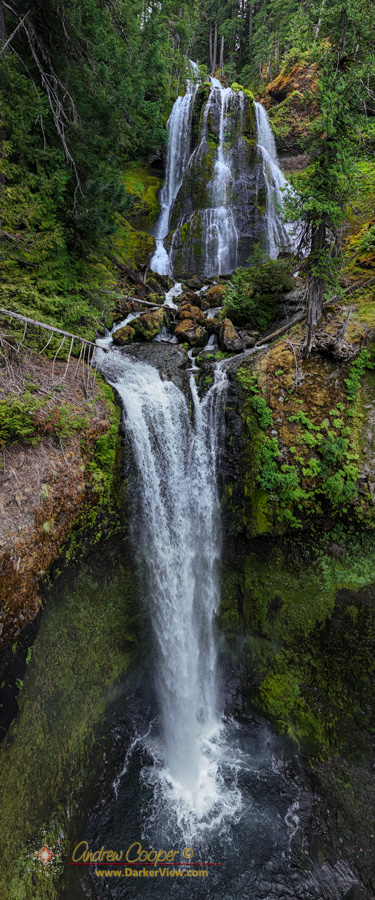
The drone made a huge difference. Falls Creek Falls is particular is quite large and impossible to properly capture from the ground. The drone made all the difference, able to sweep along the waterfall from the air or fly right up to unreachable locations and shoot at lovely angles.
For the most part I was just spending time with the folks, a week hanging out and even doing some chores around the house.
I did have one day planned in an otherwise unplanned week… A hike somewhere, a chance to enjoy a bit of summer in a classic Pacific Northwest sort of way. This year it would be waterfalls.
I had two waterfalls picked out… Falls Creek Falls and Panther Falls, both located in the hills above Carson, on the Washington side of the Columbia River Gorge.
Along with the waterfalls I had one other stop planned, a quick excursion to the new Mitchell Point Tunnel. Add a lunch somewhere along the way and I had a full day.
An important part of the plan was an early start. I left the house at 4am for a dark drive up the gorge for a planned dawn arrival at the trailhead.
The morning dawned clear and beautiful… It should be a great day.
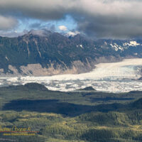
Southeast Alaska has so many glaciers, but very few of them are easily accessible. Most require long hikes into wild coutry, floatplanes to remote lakes, or boating through iceberg choked waters to reach. Sheridan Glacier you can drive to.
Icebergs scattered across the lake in front of Sheridan Glacier
The glacier is only a few miles from the airport reached by a short gravel road, and an even shorter trail through the woods. Not the glacier itself, as that is about a mile away on the other side of a lake. Rather you reach the shore of a lake covered with icebergs, creating a spectacular scene with the glacier in the background.
At the end of the road the glacier is just visible through the trees as glimpses of ice. A well maintained US Forest Service trial leads to a point from which some of the lake and glacier can be seen.
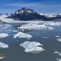
Sheridan Glacier viewed from an aircraft landing in Cordova
This first viewpoint has a clever feature. Here you find a simple post with a small recess milled into the top. You can place a cellphone on the post and take a photo. Sending the photo to an email address allows the Forest Service to monitor changes in Sheridan Glacier over time. Not by installing their own expensive remote camera, but rather by simply having visiting tourists contribute their photos.
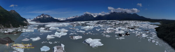
Going a bit further, my brother and I hiked the short trail around and down to the shoreline looking for a better view of the iceberg covered lake. Where the trail emerged again onto the shore a small moriane offered the view we were looking for, a place to sit and enjoy spectacular scenery. From this little moraine also flew the drone to gain a better vantage for some photos.
The lovely weather would not last long, it was a good decision to use this first afternoon in Cordova to get out and see the glacier and explore further to the end of the road.
Sheridan lake with scattered icebergs from Sheridan Glacier
On the west end of the park is a vast area I had never ventured into, the Kaʻū Desert. This was going to change, the two hikes on the top of the list for this particular stay in the park were Mauna Ulu and the Kaʻū Desert. Having accomplished the prior it was time for the latter.
The Kaʻu Desert along the Mauna Iki Trail
There are two sets of trailheads to enter the Kaʻu Desert. Several of the trailheads are along Highway 11 on the north side of the area. To avoid leaving my car on the side of the main island belt road I chose to use one of the trailheads along the Hilina Pali Road inside the park. Here one can find the Maunaʻiki Trail leading to Twin Craters.
Mauna Ulu first erupted in May 1969 and would continue for the next five years. In the course of those eruptions lava would occasionally fountain over 1,700ft high while flooding much of the surrounding area, eventually constructing a lava shield nearly 400ft above the original ground level.
Mauna Ulu as seen from the top of Puʻu Huluhulu
In many ways the Mauna Ulu eruption was very similar to the Pu‘u ‘Ō‘ō eruptions that would start a decade later and continue for well over three decades. It is the Pu‘u ‘Ō‘ō eruptions that formed my first memories of Kilauea with television news of homes burning in the Royal Gardens subdivision and visits to the ocean entries at Kalapana. While Pu‘u ‘Ō‘ō remains somewhat remote, Mauna Ulu is far more accessible.
The region south of Waikoloa along the shore seems to be a barren field of lava with little to offer beyond miles of dark rock and baking sun. That may seem to be the case, but there are surprising gems out in those lava fields.
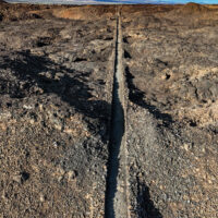
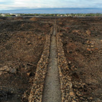
Looking along the King’s Trail south of Waikoloa
The plan? As usual hike the King’s Trail south from Waikoloa, but this time explore some of the smaller trails I had passed by in the past. Perusing the satellite imagery reveals a surprising number of trails through the lava. Considering the substantial effort it takes to cut a trail through the worst aʻa lava those trails must be significant somehow.
A long weekend? Cloudy enough to preclude a night with a telescope? May as well take a walk.
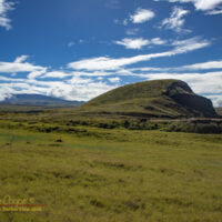
Puʻuhinai with a snow capped Mauna Kea behind
There are a few great hikes around the island, but often I just do not feel like driving very far. Thus I head out to Puʻuhinai again, one of my favorite local hikes just outside the village.
Recent rains have turned the landscape green and lush. Everywhere there are signs of flowing water, even along many of the old ranch roads, the downpours have been intense lately. The mauna have had snow all year so far, a reminder of a very wet winter rainy season.
Rather than spend the evening obsessing over election results I opted to take a hike. Nothing dramatic, just a short loop hike close to home, along the shoreline south of ʻAnaehoʻomalu Bay .
Looking north the Waikoloa Resorts along the King’s Trail
The plan was to use the King’s Trail to quickly hike a couple miles out, then to take my time hiking back along the shoreline. I timed my start so that sunset would occur while I was coming back along the beach.
While this section of the King’s Trail is over 150 years old, it is in excellent condition and allows easy hiking across the lava fields. The trail cuts absolutely straight over the ridges and tumuli of piled rock, much faster than slogging through the beach sand.
I had hiked the shoreline here many times, but had not hiked any real length of the King’s Trail. The trail crosses the lava flows well above the coastline, as a result it can be brutally hot under a tropical Sun, while the shoreline offers regular shade and a cool ocean breeze.
This particular election day evening the Sun was muted by a broken overcast sky. Why not use the trail?
A little drone footage, a lot of stills. With the drone, the phone, and the little mirrorless M5 I was carrying three cameras for the morning. Most of my daypack was camera gear, along with a small first aid kit, 1/2 gallon of water and iced tea, and munchies.
I seem to have solved some technical issues that plagued my videos from earlier this year. Using a ND32 or ND64 filter really does help slow shutter speeds in full sunlight. You can see some choppiness in the faster pans, but that is mostly from using 30fps for the final rendering rather than in the source.
What did cause trouble is the vibrant greens of Puʻuwaʻawaʻa, some shots came out muddy yellow-green. Need the check how I am setting the white balance in the drone, need to use fixed sunlight rather than auto.