Mauna Kea Looms
When you want to see the stars, find someplace dark

As if hurricanes, earthquakes, flash floods and tsunami are not enough, the USGS just raised the alert level for Mauna Loa to advisory/yellow.
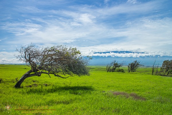
Processing the photo I realized I could not make it green enough. If I pushed the saturation far enough to resemble reality I would be accused of over-processing the image. Yes, the ranch lands around Waimea and Waikoloa are that green right now.
The normal annual rainfall in Waikoloa is about 12 inches. Over the last few weeks we have received eight inches in our unofficial rain gauge on the front lanai. Normally summer is the dry season here, with most of the rainfall occurring during the winter months. The result is endless green across the mountainside.
As the rains have continued this last weekend, another half inch in the rain gauge, it will stay green. Eventually the rains will come to an and, everything drying out, returning the pastures golden brown again. Then, of course, the mice will come.
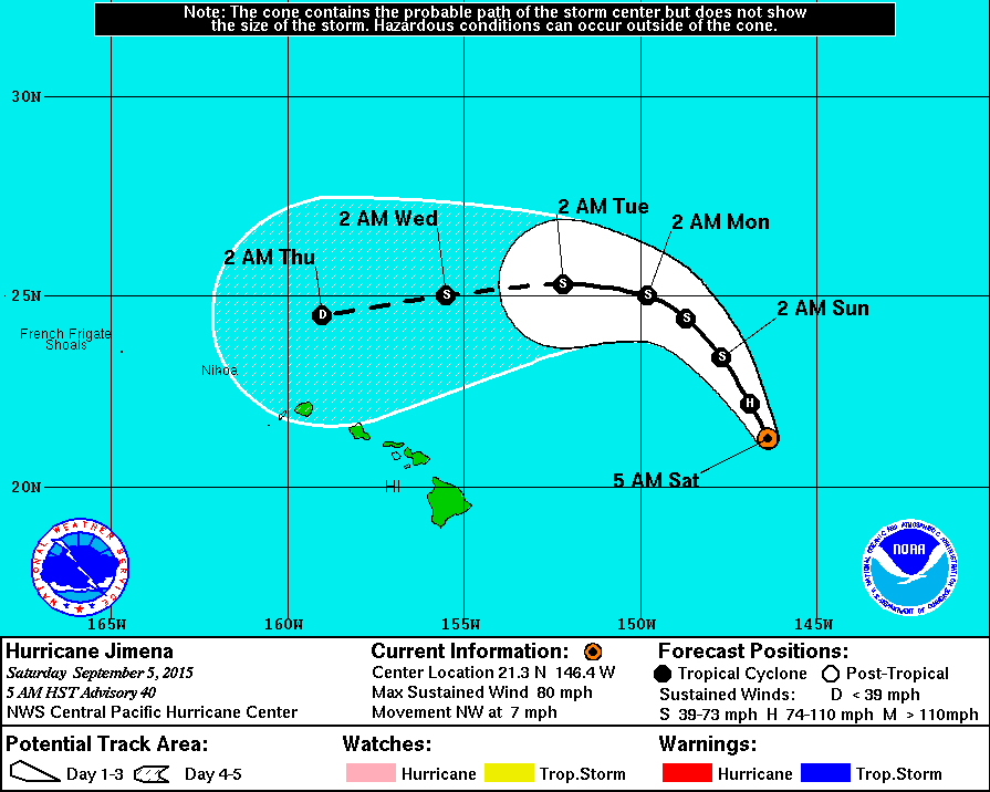
Predicted hurricane tracks continue to be the subject of conversation around the islands. The latest now shows Jimena curving back at the islands, when the predictions from five days ago showed the storm tracking off to the far north. Really?
At least it missed our island. Now it is the residents of Oahu and Kauai that need to worry.
The satellite views of the central Pacific are endlessly fascinating. Three major hurricanes surround the Hawaiian Islands. Social media continues to buzz, with re-posts of the imagery.
So far only minor effects in the islands… Major surf on the northern and eastern shorelines, closed beach parks, and lousy observing weather keeping the telescopes shuttered.
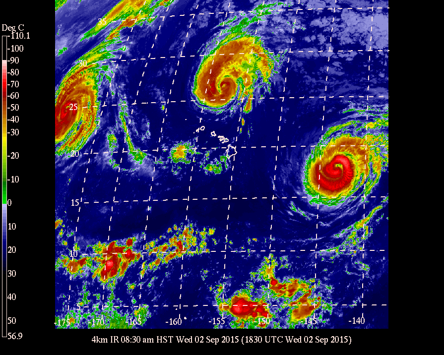
Hurricanes whirling past, satellites breaking up overhead. I am reluctant to ask… What is next?
A beautiful image from the NOAA-NASA GOES Project of a full disk Earth. Off to the west of the islands you can see the re-formed Hurricane Kilo, to our immediate east if Ignacio, with Jimena right behind. The forecast calls for tropical storm force winds to begin on the island as soon as tonight. Also visible is an active region of thunderstorms off the Mexican coast, the spawning ground for the next hurricane.
Click on the image for full glory!

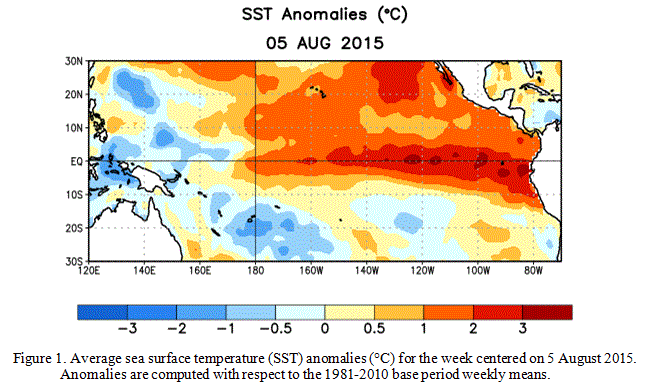
The intensifying El Niño event in the Pacific is looking to be the strongest event of the last 50 years. Some news outlets have dubbed it the “Godzilla” El Niño.
Officially referred to as ENSO, or El Niño Southern Ocsillation, this event is a period of dramatically warm surface water temperatures that occurs across the equatorial Pacific Ocean. These events usually alternate with periods of cooler temperatures, or La Niña events, and can have dramatic effects on weather across the globe.
The immediate effects of the warming water are already being felt… Water temperatures around the islands are at least 2°C above normal, pushing our normally cool water into near bathtub temperatures. Local divers are commenting on the warm water temperatures, those who normally wear wet suits are comfortable without.
This warm water is also fueling the series of hurricanes sweeping past the islands. The storms just keep coming. It will be an interesting year!
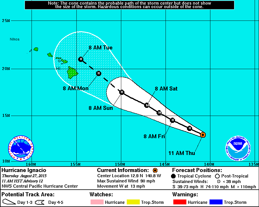
It looks like yet another hurricane is coming this way, the island squarely in the predicted path. The seemingly endless series of storms passing through is making the 2015 hurricane season one of the most active on record.
Ignacio is expected to become a major storm, crossing the island as a full hurricane. If that is not enough we have Jimena further out and following a similar track. No one expects that to be the end of the series either, with sea water temperatures well above normal and continuing to warm there will be further storms.
I am truly grateful we live on the leeward side of the island, sheltered from the worst of the effects of these storms. A 14,000ft mountain standing between our house and the oncoming hurricane. I do worry about our many friends who live on the other side of the island.
As the storm nears and if it becomes apparent that the island will be hit we will perform our last minute storm preparations, fill the water jugs and secure the lanai furniture. Everything else is already done, held over from the last storm, plenty of emergency supplies and propane on-hand.