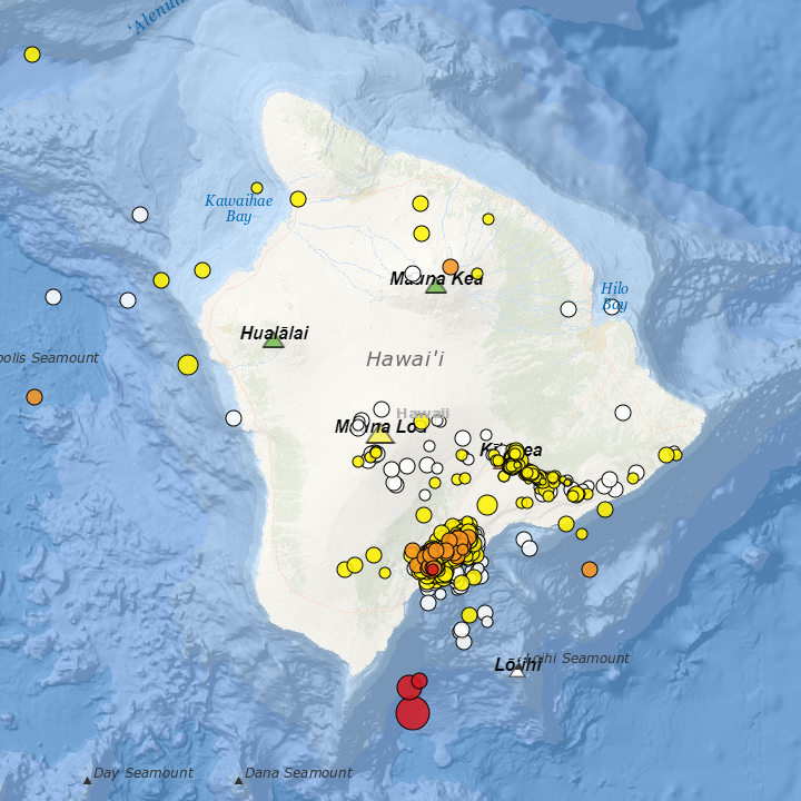
Well? That was the strongest shake we have had in a while. Magnitude 6.2 well offshore of the south end of the island.
The whole house rattled for a while, then a few sharp bangs, then it rumbled on for a while longer. Nothing knocked off shelves, just a steady rattle of plates and photos on the wall. The 3D printer took no notice, happily plotting along.
The cats did take notice, Electra disappearing under the bed, not to re-appear for a while. Ras was all perky-eared and vigilant.
For this quake I guessed not only the distance correctly, but the magnitude to within 0.3, (guessed 6.5, USGS revised 6.2). We have plenty of experience with big island shakes at this point. I felt both the S and P waves arrive, that gave me distance. What surprised me is the depth, 21 miles down, that is below the crust, into the mantle.
USGS plot of a magnitude 6.1 earthquake off the south end of the island with aftershocks, Oct. 10, 2021
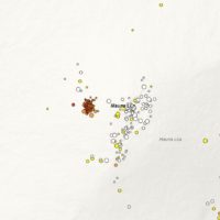
Like most armchair volcanologists on this island I have been monitoring Mauna Loa more closely lately. The deformation graphs in particular have been? Interesting. I have even gone so far as predicting that we will not get through the year without a Mauna Loa eruption.
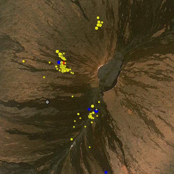
An intense earthquake swarm on the NW flank of Mauna Loa, March 30, 2021
The area of concern has been the western rift zone, exhibiting steady and shallow seismic activity for the last several years. More concerning is the rate of inflation shown in the GPS data, This seems to have doubled in rate around last October.
Then comes today.
An intense seismic swarm is currently occurring beneath the NW flank. Still fairly deep. a few kilometers below the surface, but getting shallower. Magma is definitely moving, a sizable mass moving upwards and emplacing itself higher in the volcano.
This may come to nothing in the near term. Like many seismic swarms it may stop. Just part of the process towards a future eruption some years from now, or never. Or we may be seeing the first step in a new eruption. I will hold to my prediction of an eruption sometime in 2021.
This one woke up everyone in the house, cats included.
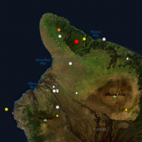
A plot of the magnitude 3.1 in North Kohala on the morning of Nov 9, 2019
While the eruption of 2018 had the island shaking, 2019 has had seemingly few felt earthquakes. I have gone several months without feeling a quake.
It was something of a surprise when the house rattled this morning just before 6am.
Deb asked me, “Was that a quake?”
“Yes.”
From the short, sharp rattle I guessed it was close… I was right, a magnitude 3.1 in North Kohala. It was also deep, a bit over 14 miles down. This was a classic settling quake as the weight of the island presses into the ocean crust.
On a Saturday morning we did not stay awake for long, cats included.
Update: The quake was later upgraded to a 3.4 after review by the USGS.
Two earthquakes of the same magnitude strike our island a month apart. Two events that are quite interesting to us at the observatory. Both about the same magnitude, both occurring deep in the island, one was far more forceful at the telescopes causing some minor damage, the second caused no damage that we have found despite a thorough inspection.
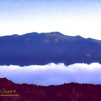
Mauna Kea seen at dawn from Mauna Loa
Any strong earthquake is a concern for the telescopes. We need to know immediately just how strong the quake was, how much potential for damage occurred.
The telescopes are precision instruments with many delicate parts. On the other hand earthquakes are common on this volcanic island and we have learned how to deal with the shaking.
When attempting to measure the possible damage to the telescope it is not earthquake magnitude that is interesting. Rather we want to know the peak ground accelerations that occur at the summit facility. The actual forces that could potentially cause damage. These are measured by means of a logging accelerometer mounted in the basement of the observatory.
Can we keep our natural disasters to one-at-a-time?
A large wildfire burning above Waikoloa VillageThis is getting to be just a bit much. We have an ongoing eruption on Kilauea that is larger than anything the volcano has put forth in centuries.
As a result of the eruption we are experiencing daily earthquakes of mag three to five. Not counting the hundreds of first and second magnitude earthquakes each day. The eruption also brings serious air quality issues, cracking highways, and more
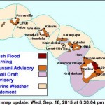
There is currently a large brush fire burning above Waikoloa Village and roads remain closed for a second day. Like most village residents we spent a nervous night wondering if the high winds would allow the fire to jump the firebreaks.
And to top it all off we now have Hurricane Hector bearing on a direct course for the island.
Just what is next? A plague of frogs? Oh yeah, we have that too.
The ground beneath us is one constant in life you just expect to never change. Solid and unyielding, we build our lives upon the firm foundations of the Earth. When this constant betrays us it is truly disconcerting. The world loses some of its comforting stability.
Last Friday was a day when our islands were reminded of the instability of our world in a rather abrupt fashion.
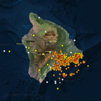
USGS Earthquake Map for May 6, 2018It was clear weeks ago that the volcano was restless. volcanophiles like myself found ourselves checking the reports and charts daily. The deformation graphs are a good indication of what is going on inside the volcano.
The tiltmeters indicated that pressure in the caldera and Puʻu Oʻo had been building steadily. At the same time the activity in the 61g lava had been waning. Where was the magma going?
While speculation was rife, no one really knew what was coming. Three decades of eruptions from Puʻu Oʻo has become somewhat routine. People forget that Kilauea can be, and usually is much more unpredictable. That destruction can appear anywhere on her flanks.
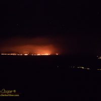
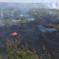
Lava emerges from a fissure in the Leilani Estates subdivision on May 5th, 2018, photo from the USGSThe first lava surfaced Thursday afternoon in the neighborhood of Leilani Estates. The observatory staff had gathered to celebrate a pau hana that afternoon, an early Cinco De Mayo celebration with Mexican food. Many of us ate our tacos and quesadillas in the conference room, where the large screen was showing drone video of the first fissures.
We worried about the homes in the neighborhood and the people we knew who lived in the area. We compared notes, recalling who lived exactly where, fearing the lava flows would quickly spread. This was looking like a worst case scenario, a repeat of 1955 with more people and homes in the way.
Despite the outbreaks of lava in the rift zone the previous afternoon, we expected a routine Friday atop Mauna Kea. I had a list of tasks to complete… Inspect the K1 azimuth wrap, drill some anchor points to allow installation of the new ice monitor receiver on the roof, look for some spare parts for an encoder.
It should be an easy day on the summit… It was not.
Friday became a day I will remember for a long time to come.
I understand that some of our family can be a bit fuzzy on island geography. We have had a few exchanges with family members over the last couple days where we have had to remind them that we live on the other side of the island from the volcano. Yes, we are just fine and in no danger from the new eruption.
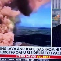
Confusing the Hawaiian islands on Fox NewsApparently some who should know better have similar issues with geography.
Like Fox News.
At least our family members understand the difference between Hawaiʻi Island and Oahu. But a national news network? I guess that to many Oahu is Hawaiʻi, rather in the same way that Los Angeles is California. Shall we just ignore 230 miles of Pacific Ocean and a few other islands in the way.
Yes, Deb felt the earthquakes in Waikoloa, but they were not bad. There was not even a broken glass at the house despite a magnitude 6.9 earthquake at the the other end of the island. We are 65 miles and two very large mountains away from the volcano.
I was at work and experienced the earthquakes at the summit. Mag 6.9 is now my personal record for strongest earthquake felt, I really do not need to feel anything larger.
While we are safely away from the new lava flows, there are many who are not. It is hard to describe my emotions when seeing video of a house burning as the lava pushes through. Nicely kept gardens surrounding the house betray the effort and pride of the home owner. You can feel dimly the shattering loss of a home and everything that goes with it.
Being an inveterate volcano watcher, I have not only been watching the new flow on Kilauea, but keeping a wary eye on Mauna Loa as well. The USGS has steadily been increasing the alert level on this largest of the Hawaiian volcanoes over the last year.
On this unstable rock we live, we get a fair number of earthquakes. Of course not every bump you feel is seismic, sometimes it is just a big truck on the highway. You look on the USGS Recent Earthquakes page anyway, just to see what it was. Not this time, must have been a truck. While I have the page loaded I look about… Wait? What is that cluster on the NW flank of Mauna Loa? I do not remember seeing that before!
For the last year or more there has been a steady cluster of small earthquakes just to the southwest of the main caldera. This notable cluster is usually visible when you stop by the earthquake page and indicates magma motion below the summit. It is a big part of why the USGS has upped the advisory level. The cluster on the west flank looks new to me, a lot of small quakes, some deep, some as shallow as 600m.
I am sure someone over at the USGS is looking at the same cluster and asking the same questions. Maybe they have better answers, but they have not published anything yet. Maybe, like so many times before this cluster will fade away, not to appear again. It is however a reminder that magma is moving down there, the mountain is swelling, someday she will erupt again.
Today I will be driving up and down the mountain. I know I will be looking across the saddle at the looking bulk of Mauna Loa and wondering for the thousandth time. Will I see an eruption from her during my years on island?
Active advisories for Sep 16, 2015. Tsunami, flash flooding or stormy seas, take your pick.This is getting downright ridiculous. Over the last few weeks we have had multiple flash floods, a few hurricanes wander by, and a tsunami come ashore. Admittedly none of the hurricanes have come directly in, missing the island. The tsunami was only about a meter and no damage has been reported. The flooding has caused some property damage and a lot of cleanup has been required. Aliʻi drive is a mess again as are several other roadways. An interesting summer.
It is not a hurricane watch, but rather a tsunami watch that is currently in effect for the island. This afternoon’s 8.3 magnitude earthquake in Chile may have generated a tsunami that may arrive around 3am tomorrow morning. The early data from stations along the Chilean coast report a tsunami has indeed occurred of between ½m and 3m in height. Oh the fun of living in paradise…
Update: Tsunami watch downgraded to an advisory, minor effects expected.