Three Hours on Two Tanks

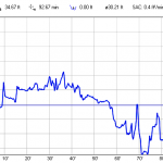
I have had a few dives over 90 minutes, an hour and a half, on a standard 80 cubic foot aluminum tank. This time I managed two back to back dives totaling nearly three hours on two tanks. Not bad for air consumption! Admittedly I was moving slow, doing photography, on the other hand neither dive was all that shallow, averaging 30ft with deeper excursions.

Leaving Honokohau Harbor for a day of diving the Kona Coast
It was another day of diving off the Aqua Safari with the usual crew. Dennis, Sky, Pete and myself headed north from Honokohau for Kua Bay.

Kua Bay is the last public day use mooring north of Kona for a long distance, the next buoys are at Anemoʻohalu Bay, almost 10 miles further north. The mooring is adjacent to the popular Maniniʻowali Beach, a beautiful crescent of sand that is well loved and heavily used. A prominent finger of coral juts out from the shore north of the beach, creating a nice 20ft wall to explore.

I spent the entire dive poking along this wall, looking for small invertebrates. I was rewarded by an assortment of nudis and flatworms. Most were species I had seen before. One flatworm was something different, a species I am still trying to identify.

Dive Profile for Kua Bay
Dive Profile for Kua Bay on 26March 2013
For the second dive we headed north. There may be no further official day-use public moorings, but there are two large moorings just offshore the now closed Kona Village Resort. We tied up to the outer of these two moorings to see what we could find. The mooring is sited just outside of a coral shelf. While the mooring sits in 35ft of water, the shelf just inshore rises to about 15ft. Further out it appears the coral drops to a large sand flat, this we did not explore, spending the entire dive working the shallower wall of coral.

White Tip Shark
A white tipped reef shark (Triaenodon obesus) under a ledge in front of Old Kona Village
About 70 minutes into the dive I figured it was time for Pete to show up. I had not seen any sign of him for quite a while, he should be by any time now… He has had a habit of coming right over the top of me and trying to surprise me, it works with Mark, I think he is frustrated with my lack of reaction. Pete is right on time.

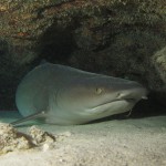
I signal to him, making a shark symbol, a flat hand held sideways to the forehead, that gets his attention. I lead him under a ledge a few feet away, where there is indeed a white tip shark hanging out. When we surface a few minutes later he sums up the encounter… “That is the biggest white tip I have ever seen!” Yeah, it was pretty big. Living up to the scientific name as well, Triaenodon obesus, a well fed shark, a little fat even.

After washing up the boat we head into Bite Me for dinner and to talk story. We thumb though the photos of the day reviewing all we had seen. It was an excellent day diving. The water conditions were notably better than a month ago. Summer is arriving, the swell settling down, bringing clearer water conditions. Looking forward to a summer of more diving!

Substation Observing Site

Another site that allows an amateur astronomer to take advantage of the pristine skies of Mauna Kea is located next to an electrical substation just a couple hundred yards east of the Mauna Kea Visitor Information Station. Here you can enjoy a truly spectacular sky above the tropical haze and VOG of lower elevation Hawaiian locations. Far from the modest lights of Kona or Hilo there is almost no light pollution and the tropical inversion layer often keeps the clouds and rain well below this mountain site. While the site may see some early evening use by sunset watchers and possibly a tour van doing a star tour for their guests the majority of the night will offer an escape from the crowds across the road leaving the observer alone to enjoy the universe.


View Larger Map
Map of the substation site
This location is across from the Mauna Kea VIS and accessible up a small gravel road passable by just about any vehicle. In the saddle between two small pu’us (cinder cones) there is a large flat area adjacent to a small electrical substation. This site offers excellent dark skies at 9,200ft (2,800m) with open western and eastern horizons. Mauna Kea blocks the northern horizon to an elevation of about 18 degrees with Polaris sitting right over the summit. Pu’u Kalepeamoa to the south (a small cinder cone) block some of the southern horizon.

The Substation site has some advantages and some disadvantages…

  • A dark site away from the lights and crowds if the VIS, but still nearby if you are to need access to the VIS bathrooms.
  • An open cinder area with enough room for twenty or more vehicles and telescopes.
  • The site is occasionally used by one or two of the summit tours to allow their guests a look through a telescope. This will usually take less than an hour before they pack up and leave.
  • Sunset viewing guests from the VIS cross the area to access the pu’u to the south where sunset may be viewed with a clear view of the western horizon.
  • The small pu’u to the south will block some of the southern sky.
  • If there is a east or west wind it can come through the saddle across the site making conditions less than ideal.
  • The site lies on DLNR administered land and is subject to DLNR rules. Camping is not permitted, where camping is defined as possession of “camping paraphernila” after dark. Make sure you do not have a tent, sleeping bag or other obvious camping gear along. In practice this has never been enforced at this site.

The VIS is more sheltered as it is below the small ridge and offers a somewhat better southern horizon.

The site is easily found by turning off the main road just below and opposite the entrance to the Mauna Kea VIS. A break in the guard rails provides access to a short gravel road that proceeds straight up the hill to the saddle and the substation.

Mauna Kea Star Trails
Star trail image taken from the Substation site looking towards the mountain. Visible are the lights of Hale Pohaku, switchbacks up to the summit and a golden swath in the sky painted by the Keck AO laser

Counting Whales

At some points there were half a dozen different groups of whales in sight at the same time. The spotters called whale activity in a confusing chorus of activity and locations. The annual Hawaiian Islands Humpback Whale National Marine Sanctuary Ocean Count picked a pretty good day. Given the recent winter storm I had half expected to be rained out, some of the east Hawai’i sites were, but we had perfect conditions.

Counting Whales
Counting whales at MM7 north of Kawaihae
Last month a thin haze that hampered visibility, the resorts on the far shore barely visible. This year we could count tourists on the beach at the Mauna Lani about 10 miles away. Some of the whales we spotted were in front of Kiholo Bay about 16 miles to the south. When the visibility is good, the Mile Marker 7 is one of the best whale watching sites in the entire island chain.

Not that we always needed to look that far, often enough the whales were at the base of the bluff, just a few hundred yards below us. In one half hour data interval we counted 24 breaches. Just a few whales around.

No argument, it was a good morning to be counting whales. From the looks of the preliminary results, our site counted far more whales than any other site across the islands. No surprise, this stretch of coast is always thick with whales. The only sites that challenge MM7 are the sites just north and south, Lapakahi and Pu’ukohola Heiau, from the data those folks had a good day as well.

Hawai’i in the 1940’s

Some great videos are circulating through the Hawaiian blogs… It seems that someone toured the islands back in the 1940’s and took a few reels of 16mm film. These vintage films turned up at a garage sale and were rescued by Tim Peddy and Rick Helin, who understood their value. With the assistance of the California Pioneers of Santa Clara County and a special telecine converter the film was transferred to a digital format.

Watching the films is a great look into life on the islands six decades ago. Photos of places familiar and yet removed in time.

Saddle road seems familiar, it has gotten a bit better. The scenes of paniolos driving cattle into the surf to to be towed to a waiting freighter are simply fantastic!

In the second clip I see some footage that was clearly not taken on the Big Island, probably windward Oahu judging by the cliffs in the background.

The film of the Inter-Island Airways (now Hawaiian Airlines) Sikorsky S-43 flying boat is great. There are also great aerial shots of the Hamakua Coast showing and seemingly endless expanse of sugar cane fields and plantation towns.

Crossing Paths with a Humpback

Any sort of water activities, fishing or scuba diving, off the Kohala coast in winter involves a chance of seeing a whale. Indeed, Kohala is not just the part of the island we call home, it is the Hawaiian word for whale. In winter the whales are here in large numbers… Boat or drive north of Kawaihae and the odds approach certainty that you will see not just a few, but a lot of Humpback Whales as they cruise the waters along this sheltered coastline. Rental cars are parked along the coastal highway wherever a pod can be seen. Just getting to a dive site can involve navigating around a pod or two as blows and fins are seen in all directions. Dive beneath the water and you can listen to the songs of the whales echoing eerily through the blue.

Humpback Trio
A trio of Humpback Whales pass by off of point Adolphus, Alaska, 30 June 2004
During the winter these whales can be found around all of the Hawaiian Islands. They come here to mate and give birth in the warm tropical waters. The most sheltered areas in the lee of the large islands have the greatest concentrations, this includes the Kona and Kohala coast of the Big Island. Through January, February and March the whales can be seen all along the coast. Much of these waters have been designated the Hawaiian Islands Humpback Whale National Marine Sanctuary to protect these unique animals during their winter stay.

Bubble Net
Humpback Whales closing the bubble net at the entrance of Peril Straight, Alaska, 25 July 2006
Come spring the Hawaiian population of whales head north, to the food rich waters of Alaska. It is an interesting experience, in addition to regularly seeing these whales off the Kohala Coast, I regularly see them on the other end of the migration while boating in Alaska. The activity of the whales is different at either end of the journey, in Hawai’i they pretty much just hang out and sing, slowly cruising the coast or just hovering below the surface for many hours. In Alaska it is all about eating, here you watch whales circling through food rich areas over and over. Sometimes the whales cooperate to create bubble nets, encircling shoals of krill or herring.

In past journeys to Alaska I have had many opportunities to watch these majestic animals. We regularly stop and watch when we get the chance, drifting while whales feed around us. Hopefully this results in good photos to enjoy and post on the blog. At the end of the trip I fly back to Hawai’i to resume my usual life. But when winter comes the Humpbacks will follow, returning to the warm tropical waters around the islands to mate and give birth to the next generation. I look forward to seeing them off the Kohala Coast and listening to their songs while diving in those warm waters.

What are the odds of encountering the same whale at both ends of this journey? I wonder.

Jumping the Pond

I normally get on an airplane about once or twice a year. This summer that will be three trips in two months, with just a few weeks in-between. Two of those hops will be back and forth to the mainland, a five hour flight from the islands.

Over the Pacific
34,000ft over the Pacific Ocean
I am on the first leg of the last trip as I write this, the third jump across the pond in as many weeks. The first destination is Seattle and a family reunion to celebrate my parent’s 50th wedding anniversary. Then it is off to Alaska to do some fishing and bring the boat down the coast to the Puget Sound for the winter.

As I look down on the expanse of blue water my mind wanders. Perhaps the upcoming boating expedition has lent a nautical meme to my thoughts… I think of those who sailed into that blue with no idea of what lay ahead. The explorers who set course into the vast Pacific not knowing if they would find a reef the hard way in the night.

I consider the ancient Polynesians who chose a course without a compass or chart, navigating by the stars and waves. Their journeys would last for weeks or months, possibly much longer if the winds did not cooperate. Using hard earned knwolege they would locate the tiny specks of land scattered acrooss this vast expanse of blue.

Here I sit in relative comfort. Perhaps a bit confined, a small seat amoung many others, but I need endure for only a few hours. I sit at the window and watch the small clouds slide by below, trying not to look at the clock. One can look at the map, but somehow fails to convey the reality of that seemingly endless blue outside my window. I imagine a double hulled canoe, with coconut sails, upon those waves 34,000ft below.