Please Define Normal

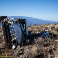
We are now more than two months into this new eruption from Kilauea. Two months ago the fissures opened in the Leilani Estates subdivision and homes began to burn.

Fissure 8 Lava Fountain
The lava fountain at fissure 8 in Leilani Estates throwing lava hundreds of feet in the air on June 4th, 2018
For two months this slow motion catastrophe has continued. While a major earthquake may be over in minutes, or a hurricane over in a few days, this eruption just goes on. For the folks in lower Puna the lava continues to destroy homes and disrupt lives.

For those of us outside the eruption zone things are not quite as immediate. We read the daily news, peruse images of helicopter overflights each morning, and wonder when it will be over.

The multiple county civil defense status reports and various emergency alerts that pop up on our phones each day provide current information… A bit of the Mamalahoa Highway has collapsed in Volcano Village with a one lane restriction, the road to Kalapana has re-opened, there is no tsunami threat from that last 5.4 magnitude earthquake.

July 7, 2018 Summit Collapse Earthquake
A plot of the July 7, 2018 summit collapse earthquake as recorded by an accelerometer in the Keck Observatory foundation
Every day is punctuated by a magnitude five point something earthquake. These summit collapse events have become very regular. You can guess when they will occur as the frequency of small quakes increase around the caldera.

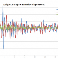
For the most part these events pass unnoticed by much of the island. The volcano area gets shaken up pretty well, but these fifth magnitude quakes are often not felt very far beyond that.

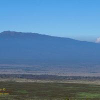
On the summit of Mauna Kea these daily quakes often do disturb the telescopes at night, bumping the tracking and ruining exposures, but otherwise too weak to cause any damage to the facilities.

Hualālai peeks over a thick layer of volcanic smog, or vog
The most significant island wide impact has been the vog, wreathing the island in a sulfurous haze. Sulfur dioxide pours from the active vents, mixes with water in the air and forms a thick brown grey haze.

When the vog is bad you not only see it, you smell the sulfur, it irritates eyes and nasal passages. Fire and brimstone reaches out to touch us all.

While the vog makes for spectacular sunsets, the vog can also be thick enough to curtail outside activity. A day like today, with brisk trade-winds to clear it away, is a welcome relief.

Fissure 8 Lava Fountain
The lava fountain at fissure 8 rising about 250 feet as this Kiluaea eruption continues unabated.
Opportunities to legally witness this eruption are few, authorities have been enforcing the evacuation area increasingly strictly. Legal options are the fly or float to the eruption. Deb and I chose to fly a month ago, a helicopter flight I am sure we will remember for a lifetime.

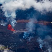
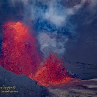
I have not attempted to go to photograph the lava river, despite a very strong desire to do so. The county and state have repeatedly talked about opening a lava viewing area. while there is a great deal of pressure from the community, so far nothing has materialized.

We are so ready for this eruption to be over.

Given the collapse of the summit caldera and the enormous volume of lava emitted so far, it may be possible that when this is over there will be no further eruption for a while. It may take a while for the volcano to recharge, perhaps a year or two. Will we return to the pattern of intermittent eruptions that was seen through much of the 20th century?

Connecting the Community

This island is a small community, anything that happens is likely to involve someone you know, or a friend of theirs. There are often only a one to three degrees of separation between you and nearly every event that makes the local news.

Mauna Kea Wreck
A wrecked Toyota pickup truck about a mile below Hale Pohaku
Even someone who has not grown up here seems to become quickly enmeshed in the community… One day I hear news of a body being discovered on a remote Kohala coastline by kayakers. The next day at work I ask Peggi about her husband’s kayak trip… As you guessed, they found the body. This may seem unusual, but here these sort of linked events are commonplace, amplified by the small community effect.

It is amazing how fast information moves from mauka to makai, the grapevine is very well connected on this island. This connectedness is accelerated by social media. Where once you would have to wait hours or days for official confirmation, or a newspaper report, we now know immediately.

There are specific places everyone goes for this type of informations. Two notable Facebook groups cover island happenings, Big Island Thieves and Big Island Popo Alert.

Continue reading “Connecting the Community”

Typical Hawaiʻi Shoreline

Picture postcard beaches of white sand with turquoise blue water are what so many tourists imagine when Hawaiʻi is mentioned. Add a few coconut palm trees and you have the ideal beach of song and legend.

Mauna Kea Beach
The ideal Hawaiian beach represented by Mauna Kea beach on the Kohala Coast.
What surprises many tourists is that this postcard ideal is not the reality of our island. Black rock shorelines are the norm. Once under water you will find the sandy areas are interspersed with coral reef, the rocky shorelines usually supporting extensive coral reef rather than sand.

It is the coral that is the source of the white sand beaches here in Hawaiʻi, ground coral chewed and digested by the many coral eating fish. The pretty triggerfish and parrotfish chew the coral constantly, crushing the coral into a fine grained sand. Our pretty sandy beaches are literally fish shit.

Old Airport beach
Typical shoreline along the Kona coast, if there is sand, it usually becomes rock and coral at the waterline
While not exactly rare, there are quite a few, beaches where the sand continues into the water are not the rule along the Kona coastline. Most of the coastline feature black lava shorelines where the water crashes against bare rock. This rocky shoreline accounts for something like 90% or more of the coastline of the Island of Hawaii.

This stands as a stark contrast to other tropical shorelines around the world, where miles upon miles of beach are not uncommon, sand as far as the eye can see. Here on the Big Island the few truly good beaches are treasured and well used parks.

Coconuts are not the usual shoreline tree either, that role belongs to either the kiawe tree or what is locally called ironwood. Both names are not what you would find in the botanical texts. Kiawe is the island name for what the rest of the world calls mesquite or Prosopis pallida, a drought tolerant tree that covers much of the dry leeward shorelines. Likewise the local ironwood is actually the beach she-oak or Casuarina equisetifolia. The rather confusing name ‘ironwood’ is used for over thirty different species around the world.

Another surprise to many is that this island has black sand beaches. In place of ground coral these beaches are ground up lava, often created by the interaction of hot lava and cold water shattering the rock into a deep black sand. There is even a green sand beach, where the sand is in large part made up of the semi-precious gemstone olivine.

Hawaiʻi is the youngest island in the chain, the forces of erosion, coral growth, and hungry fish, have not had enough time to create the long sandy beaches. These beaches become more common as you jump northward from island to island. Oahu or Kauai have extensive beaches along a much large percentage of shoreline. The islands in the northwest Hawaiʻian islands, places like Kure and Midway are pretty much nothing but sandy beach.

We do have beaches, and they are pretty good.